
 Feeds & Data
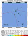
Magnitude 7.2 - SANTA CRUZ ISLANDS
2007 September 02 01:05:18 UTC
Earthquake Details
| Magnitude | 7.2 |
|---|---|
| Date-Time |
|
| Location | 11.510°S, 165.814°E |
| Depth | 35 km (21.7 miles) set by location program |
| Region | SANTA CRUZ ISLANDS |
| Distances | 95 km (60 miles) S of Lata, Santa Cruz Islands, Solomon Isl. 435 km (270 miles) ESE of Kira Kira, San Cristobal, Solomon Isl. 680 km (420 miles) ESE of HONIARA, Guadalcanal, Solomon Islands 2205 km (1370 miles) NE of BRISBANE, Queensland, Australia |
| Location Uncertainty | horizontal +/- 9.7 km (6.0 miles); depth fixed by location program |
| Parameters | NST=136, Nph=136, Dmin=681 km, Rmss=1.02 sec, Gp= 61°, M-type=moment magnitude (Mw), Version=8 |
| Source |
|
| Event ID | us2007guae |
- This event has been reviewed by a seismologist.
- Did you feel it? Report shaking and damage at your location. You can also view a map displaying accumulated data from your report and others.
Earthquake Summary


The following is a release by the United States Geological Survey, National Earthquake Information Center: An earthquake occurred about 95 km (60 miles) S of Lata, Santa Cruz Islands, Solomon Isl. or about 440 km (275 miles) ESE of Kira Kira, San Cristobal, Solomon Isl. or about 680 km (425 miles) ESE of HONIARA, Guadalcanal, Solomon Islands at 7:05 PM MDT, Sep 1, 2007 (Sep 02 at 12:05 PM local time in Santa Cruz Islands). The magnitude and location may be revised when additional data and further analysis results are available.
Tectonic Summary
The Santa Cruz Islands earthquake of September 2, 2007, occurred along the boundary between the Pacific plate and Australia plates. In the region of the earthquake, the Australia plate moves to the east-northeast with respect to the Pacific plate at a velocity of about 91 mm/y. The Australia plate thrusts under the Pacific plate at the North New Hebrides trench and dips to the east-northeast. The September 2 earthquake’s location and focal mechanism are consistent with the earthquake having occurred as thrust-faulting on the plate interface.
The Santa Cruz Islands region experiences a very high level of earthquake activity, with over a dozen shocks of magnitude 7 and larger having been recorded since the early decades of the twentieth century. The subducting Australia plate is seismically active to depths of about 250 km beneath the islands
 Tsunami Information
- West Coast & Alaska Tsunami Warning Center
- Pacific Tsunami Warning Center
- NOAA Tsunami Warning Center
- Recent Tsunamis
- Tsunami Information Links
The earthquake locations and magnitudes cited in these bulletins are very preliminary, and may disagree with the more accurate USGS locations and magnitudes computed using more extensive data sets.
Earthquake Maps


Scientific & Technical Information

- Preliminary Earthquake Report
- U.S. Geological Survey, National Earthquake Information Center:
World Data Center for Seismology, Denver
