Tittabawassee River Reach JK
The Site is located in over-bank areas on the northeast side of the Tittabawassee River, approximately 3.6 miles downstream of the confluence of the Chippewa and Tittabawassee Rivers and located within The Dow property bounded to the northeast by a wetland with Saginaw Road to the northeast beyond the wetland, the Caldwell boat launch to the South, and to the west by the east channel bank of the Tittabawassee River, in Midland County, Michigan.
The Site includes two areas of focus.The first consists of buried, post-industrial deposits immediately adjacent to the River and extending at least 75 feet inland, near the southern end of Reach J and extending through the southern end of Reach K (the "Levee Area").The second area consists of high and low terraces, and includes wetlands, that occupy most of the Reach J/K over-bank area and are subject to sediment deposition during flood conditions.
The geographical coordinates for Reach J/K are longitude 84°12'11" West and latitude 43°34'36.2" North.
The response actions proposed will mitigate threats to public health, welfare, and the environment presented by the presence of an uncontrolled release of dioxin and furans, hazardous substances, into the food chain of the Tittabawassee River from soils located within the Reach J/K Area.
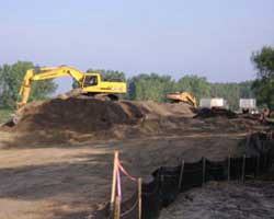
The proposed response actions include excavation of contaminated soils, capping of contaminated areas, air monitoring, limited fencing to restrict access to areas of the Site, and off-site disposal of contaminated soil.The response activities will result in the removal of approximately 32,000 cubic yards of waste material.
Legal Documents
- Enforcement Action Memorandum (PDF) (32pp., 1.5MB) July 12, 2007 Determination of an
Imminent and Substantial Threat to Public Health and the Environment at
the Reach J/K Area of the Tittabawassee River Dioxin Spill Site, Midland County, Michigan (Site ID #B5KF) - Administrative Order on Consent (AOC) for Reach J/K (PDF) (39pp., 303K) July 12, 2007
Maps
- Site map

- Reach JK site features map (PDF) (1pg. 11.0 x 17.0", 3.7MB)