 |
 | |
  | |
|
|
|
|
Lewis & Clark National Historic Trail
Nature & Science
|
|
|
nature & science includes: | Plants
|  | | | |
|
|
| |
 |

|
| NPS photos |
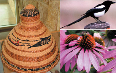
| Chief's hat similar to those Lewis and Clark purchased from the Clatsop, and a magpie and purple coneflower, two species first recorded for science by the Expedition. |
|
|  |
|
Thomas Jefferson hoped the Corps of Discovery would provide a window onto the West. The men of the Expedition were to observe and record everything, from the languages of the Indians to the dates when plants flower. In fulfilling Jefferson’s charge, the explorers became capable amateur scientists.
In preparation for the journey, Lewis studied with the best scientists in Philadelphia. As the Corps traveled, the men of the Expedition pressed plants, dried the fur of animals, and wrapped them all in oilcloth to protect them from rain and river water. They wrote detailed descriptions and sometimes drew what they saw around them. Clark sketched the courses of the rivers.
In 1806, back in Washington, Lewis laid out the map Clark had drawn and he and Jefferson looked onto the West. It would be many years before the rest of the world had the same opportunity. The official Expedition journals and Clark’s map were not published until 1814, eight years after the journey.
The science of the Expedition still allows us, 200 years later, to peer into the West of the early 19th century.
|
|
|
|

Lewis and Clark Junior Ranger Program
Become a Lewis and Clark Junior Ranger from the comfort of your own home.
more... | | 
Sacagawea
While still a teenager, Sacagawea traveled from North Dakota to the Pacific Ocean and back.
more... | | 
Lewis and Clark NHT Photo Albums
Explore the Lewis and Clark story and Trail through pictures.
more... | | 
Thomas Jefferson
The Lewis and Clark Expedition fulfilled Jefferson's dreams of western exploration.
more... | |
|
|
|
|
|
|
|
 |
|
Did You Know?
Two hundred years after the Lewis and Clark Expedition, the only physical evidence of the journey is found near Billings, MT. In July 1805, William Clark carved his name into the soft rock of what he called Pompeys Tower. This site is now preserved at Pompeys Pillar National Monument.
|
|
|
|
Last Updated: May 17, 2007 at 12:52 EST |


