
 Feeds & Data
Magnitude 6.5 - SOUTHEAST OF THE LOYALTY ISLANDS
2007 September 28 01:35:51 UTC
Earthquake Details
| Magnitude | 6.5 |
|---|---|
| Date-Time |
|
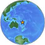
| Location | 21.257°S, 169.440°E |
| Depth | 10 km (6.2 miles) set by location program |
| Region | SOUTHEAST OF THE LOYALTY ISLANDS |
| Distances | 160 km (100 miles) ENE of Tadine, Loyalty Islands, New Caledonia 180 km (110 miles) S of Isangel, Tanna, Vanuatu 325 km (205 miles) ENE of NOUMEA, New Caledonia 1800 km (1120 miles) ENE of BRISBANE, Queensland, Australia |
| Location Uncertainty | horizontal +/- 7 km (4.3 miles); depth fixed by location program |
| Parameters | NST=268, Nph=268, Dmin=>999 km, Rmss=1.09 sec, Gp= 22°, M-type=moment magnitude (Mw), Version=Q |
| Source |
|
| Event ID | us2007hvaq |
- This event has been reviewed by a seismologist.
- Did you feel it? Report shaking and damage at your location. You can also view a map displaying accumulated data from your report and others.
Earthquake Summary

The following is a release by the United States Geological Survey, National Earthquake Information Center: An earthquake occurred SOUTHEAST OF LOYALTY ISLANDS, about 160 km (100 miles) E of Tadine, Loyalty Islands or 1800 km (1120 miles) ENE of Brisbane, Australia at 7:35 PM MDT, Sep 27, 2007 (Sep 28 at 12:35 PM local time in New Caledonia). The magnitude and location may be revised when additional data and further analysis results are available.
Tectonic Summary
The sequence of earthquakes that has been occurring southeast of the Loyalty Islands since September 27, 2007, is a geophysical phenomenon known as an earthquake "swarm"-- an episode of high earthquake activity in which the largest earthquake does not occur at the beginning of the episode and in which the largest earthquake is not substantially larger than other earthquakes of the episode.
The locations and focal mechanisms of most shocks in the current Loyalty Islands swarm are consistent with their occurring on the thrust-fault interface between the Australia plate and the New Hebrides plate. In the epicentral region of the earthquakes, the Australia plate moves east-northeast relative to the New Hebrides plate with a velocity of about 11 cm/yr. The Australia plate subducts beneath the New Hebrides plate and is seismically active to a depth of about 170 km down-dip of the swarm region.
Worldwide, earthquake swarm activity is commonly associated with tectonic regions in which both strike-slip faulting and normal faulting occurs and where magmatic activity occurs at shallow depths in the earth’s crust, but swarms also occur in regions where these conditions are not met. The current swarm is an example of a swarm that principally involves thrust-faulting and that is not at a location that is known to be experiencing crustal magmatism.
The current Loyalty Islands swarm is occurring just north of a swarm of shocks in December 25, 2003 - January 03, 2004, that contained twelve shocks of magnitude 6 or greater and that included two earthquakes of magnitude greater than 7. The 2003 - 2004 swarm included both reverse-faulting earthquakes and normal-faulting earthquakes.
 Tsunami Information
- West Coast & Alaska Tsunami Warning Center
- Pacific Tsunami Warning Center
- NOAA Tsunami Warning Center
- Recent Tsunamis
- Tsunami Information Links
The earthquake locations and magnitudes cited in these bulletins are very preliminary, and may disagree with the more accurate USGS locations and magnitudes computed using more extensive data sets.
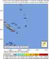
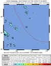
Earthquake Maps


Scientific & Technical Information

- Preliminary Earthquake Report
- U.S. Geological Survey, National Earthquake Information Center:
World Data Center for Seismology, Denver
