   |
|
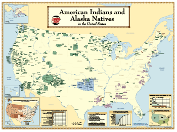
The American Indians and Alaska Natives in the United States Wall Map | |||
| The "American Indians and Alaska Natives in the United States" wall map shows the American Indian and Alaska Native Areas reported or delineated for Census 2000. The map contains related graphics that reflect Census 2000 data. The printed map is 48 by 36 inches with a map of the U.S. on the front and an enlargement for Alaska on the reverse side. Printed copies of the map are available from the Geography Division, 301-763-1128. Price $9.50 pre-paid within the U.S., International orders are $13.30 each pre-paid. | |||
 |  | ||
| Full-size GIF (for viewing) | Full-size PDF* (for download) | Full-size GIF (for viewing) | Full-size PDF* (for download) |
| *The PDF files for each side of the map are quite large and opening them within your browser is not recommended. Instead, right-click on the PDF links and choose the "save target as" option in Internet Explorer, or "save link as" option in Netscape Navigator. Once the files are downloaded to your computer they can easily be viewed in Adobe Acrobat Reader® 5.0, which can be downloaded for free from the ADOBE website. | |||
Source: U.S. Census Bureau
Geography Division,
Cartographic Operations Branch
Created: 10/01/2002
Last revised: December 31 2008