The Digital Mapping, Charting and Geodesy Analysis Program (DMAP) team is part of
the Naval Research Laboratory's (NRL) Mapping Branch and is especially focused on advanced object-oriented modeling,
database design, advanced geospatial portal implementation, environmental data
dissemination, emerging digital mapping standards, and technical reviews for
Navy usage of geospatial information. DMAP is the team responsible for developing
the Geospatial Information Database (GIDB®) Portal System, simultaneously connected to the
most disparate sources of geospatial information available and with no licensing, which
you can access by choosing one of the four user interfaces to the right.
DMAP is responsible for technical development for the VNE-NCS project. VNE-NCS is the new environmental data dissemination system for Tactical Decision Aids and Warfighters, sponsored by PEO C4I and Space, PMW 180.
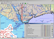
DMAP's Downloadable (Thick) Client is our
full-featured client aimed at the power user.
The thick client allows many more capabilities (e.g., unlimited number of layers,
3D visualization, importing of local shape and other data, extensive flexibility
on input formats, output formats (e.g., shape, geotiff, png, etc.), and drawing
options (symbology such as Geosym 4)). The thick client is downloaded to your machine
and auto installs for use.
The Portal is accessed through the use of one of four clients.
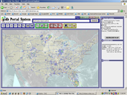
DMAP's Browser-based Client
strives to be the simplest method of interacting with the GIDB®
Portal System by providing a thematic interaction and automatic selection of "best"
data for the user. A user can look at up to 5 layers simultaneously and vary their
order and transparency.
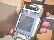
DMAP's PDA Client
is similar to our web client except it is formatted for a
PDA handheld device. You are still connected to the same vast amount of
geospatial information via our Portal; it is just displayed on a small PDA device.
The hundreds of thousands of maps provided by DMAP’s GIDB Portal can function as WMS compliant map sources via DMAP’s OpenGIS Web Map Service Interface. Using any WMS 1.1.0 or WMS 1.1.1 Viewer you can browse, view, and overlay the vast variety of map sources coming from DMAP’s GIDB Portal (see our Web Services page for a listing of public WMS Viewers). The GIDB Portal WMS Interface follows well defined standards as provided by the OpenGIS Consortium, allowing you to seamlessly integrate the GIDB Portal’s maps into your WMS Application. Soon to come is the addition of the OpenGIS Web Feature Service Interface, allowing client to retrieve GIDB Portal geospatial data encoded in the Geography Markup Language (GML), as well as the OpenGIS Catalog, providing the capability to browse, search, and query the copious amounts of geospatial data available via the GIDB Portal with any OpenGIS Catalog client application.
|

|

|


Patents: 6,684,219 , 6,950,828 and 6,985,929
Trademarks: 2,957,434 , 2,852,412 and 3,121,688
Others Pending
|
|
|