
NOTES
PDF Version of this document. To view or print a document in PDF format, download the free Adobe Acrobat Reader.
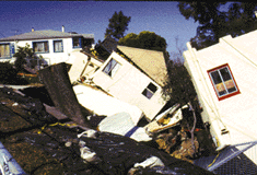
Moving your mouse over the thumbnail photos will provide a brief description of the photo. To see enlargements of the thumbnail photos and a brief description of the photo, click on the photo.
 D | USGS Warns San Francisco Residents of Landslide Dangers - In early 1998 during record-breaking El Niño storms, the USGS provided emergency workers in the 10-county San Francisco Bay region with maps of landslide hazard areas and real-time warnings of increased landslide risks. No loss of life occurred from these landslides, compared to 25 killed in comparable storms in 1982. For more information please visit the landslide Web site at http://landslides.usgs.gov/html_files/landslides/sfbay/locmap.html. |
| Flood Warnings Protect People - As floods ravaged many areas of the United States in 1998, USGS personnel maintained a nationwide system of more than 7,000 stream gages. These gages provide accurate, timely information on water levels, which the National Weather Service uses to issue local and regional flood warnings. Local officials also use stream-gage data to make timely decisions about evacuating people in flood-prone areas. Real-time streamflow data are available on the Internet at http://water.usgs.gov/realtime.html. |  D |
 D | USGS Responds to Hurricane Mitch - Just days after Hurricane Mitch devastated Central America, killing more than 9,000 people, the USGS's Center for Integration of Natural Disaster Information (CINDI) devised a computer-based geographic atlas of Central America that contains more than 100 different types of geographic information. The CINDI atlas being used by relief workers includes maps of destroyed roads and bridges, destroyed or damaged utility lines, areas of crop destruction and damage, and areas vulnerable to landslides and floods. The CINDI atlas will help the people of Central America rebuild in areas less prone to landslides and flooding. To view the CINDI atlas of Central America, please visit their Web site at http://cindi.usgs.gov. |
Preparing for Future Natural Hazard Events
The USGS conducts evaluations following disasters to help minimize the impacts of future events and to help communities prepare better hazard assessments for vulnerable regions. Evaluation data are essential for developing hazard-resistant structures, better land use planning and building codes, and emergency response plans.
 D |
The USGS protects people from natural hazards by providing up-to-the-minute (real-time) disaster information to help people get out of harm's way. Longer term monitoring and research on natural hazards help people stay out of harm's way.
For example, in 1998, the USGS released interactive maps of the entire nation showing local ground movements that are expected to occur in future earthquakes. This mapping system represents the result of more than 30 years of seismic data collection and research. The new maps will be used by local officials, planners, and designers to develop and refine new building codes; design safer highways, bridges, buildings, and utilities; estimate the stability and landslide potential of hillsides; derive insurance rates for properties; set construction standards to help ensure the safety of waste-disposal facilities; and plan earthquake mitigation practices and emergency response procedures. For more information please visit our Web site at http://geohazards.cr.usgs.gov/eq/html/intermaps.shtml.
 D |
 D |
To protect the lives and property of our citizens, the USGS will continue to gather real-time data during natural hazards, to disseminate real-time hazard data to relief workers, to do long-term monitoring and forecasting of natural hazards, and to evaluate conditions in the aftermath of disasters. One major challenge for the future will be to maintain long-term data sets on natural hazards while expanding access to the data by all who need this critical information.
Information
For more information on natural hazards research at the USGS, please visit our Web sites at http://www.usgs.gov and http://www.usgs.gov/themes/hazard.html.

![]() U.S. Department of the Interior |
U.S. Geological Survey
U.S. Department of the Interior |
U.S. Geological Survey
URL: http://www.usgs.gov/themes/factsheet/093-99/index.html
Page Contact Information:
Ask USGS
Page Last Modified: 20-Jul-2005@17:37