
 Feeds & Data
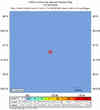
Magnitude 4.5 - FIJI REGION
2009 May 05 02:29:31 UTC
Earthquake Details
| Magnitude | 4.5 |
|---|---|
| Date-Time |
|
| Location | 21.234°S, 179.154°W |
| Depth | 630.5 km (391.8 miles) |
| Region | FIJI REGION |
| Distances | 80 km (50 miles) SW of Ndoi Island, Fiji 405 km (255 miles) W of NUKU'ALOFA, Tonga 425 km (265 miles) SE of SUVA, Viti Levu, Fiji 1830 km (1140 miles) NNE of Auckland, New Zealand |
| Location Uncertainty | horizontal +/- 20.1 km (12.5 miles); depth +/- 15.4 km (9.6 miles) |
| Parameters | NST= 30, Nph= 30, Dmin=486.3 km, Rmss=1.33 sec, Gp=126°, M-type=body wave magnitude (Mb), Version=Q |
| Source |
|
| Event ID | us2009ggai |
- This event has been reviewed by a seismologist.
- Did you feel it? Report shaking and damage at your location. You can also view a map displaying accumulated data from your report and others.
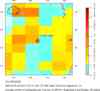
Earthquake Maps


Scientific & Technical Information
 Historic Moment Tensor Solutions
- Preliminary Earthquake Report
- U.S. Geological Survey, National Earthquake Information Center:
World Data Center for Seismology, Denver
