The first flooded area surveyed was on Grove Street, in northern St. Charles. The access road which connects to Grove Street is Somerset drive, on the west side of Illinois Route 25. This area is on the west side of the Fox River. Norton creek joins the Fox Rriver just north of the area. The Fox river Bike Trail is along Grove Street. The river flooded Grove Street and there were homes with sandbags surrounding them on the east side of the street. On the west side there are 5 homes. Three were completely flooded. These houses are along the river. The river runs south here and there are no islands. The elevation is around 690 feet MSL about the same elevation of the river. There is a ridge just east of the state highway 25 up to 740 feet MSL where there are gravel pits.
The pictures show the amount of flooding that occurred. Debris can be seen on Grove Street and on the Fox River bike trail. This shows how far the water inundated the area. Standing water on the east side of Grove Street shows the extent of the river flood before it was surveyed.

Fig 1. This is a home on the west side of Grove Street. We are looking west. The river is seen beyond the house.

Fig 2. This is another home on the west side of Grove Street. We are looking west. The house
is on the west bank of the Fox River.

Fig 3. This is Grove Street. Note the debris on the street and water on the right side of the
street. The flood once covered Grove Street. We are looking north.

Fig 4. A flooded front yard on Grove Street. The personal belongings were from the home
owner’s first floor and basement.

Fig 5. This is the Fox River Trail which runs into Grove Street. Note the debris and mud on
the plants on the left side. This is a result of the flood.

Fig 6. We are looking south on Grove Street. There are flood debris on the street and water
on the west side of the street.
The second area of flooding surveyed was along the Fox River on the south end of East Dundee, Illinois. The flood was about ¼ mile south on
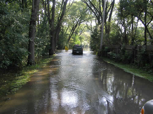
Fig 7. This is looking south on Fox River Drive. The water was about 6 inches deep.

Fig 8. This is one of the houses on the west side of Fox River Drive. You can see the Fox River in the background.

Fig 9. This is another house along Fox River Drive. We are looking west and the river is behind the house.

Fig 10. This is the corner of Fox River Drive and Bass Court. The river is on the right side of this picture. We are looking east and the Fox River bends east at this location.

Fig 11. We are looking towards the northeast on Fox River Drive. The river is on the left side of this picture about ½ of city block west. Houses on both sides of the street were flooded.

Fig 12. This is a house on the east side of Fox River Drive.
Driving through East Dundee on Washington Street and North Avenue, I saw a lot of furniture, carpets and other water damaged belongings on the curbs. Washington Street runs along the river.

Fig 13. This is the Fox River in East Dundee. We are looking south.
North of Carpentersville is the

Fig 14. Fox River Shores Park, looking north along the Fox River.

Fig 15. Water standing in the park, looking north.

Fig 16. This is the washed out Algonquin Road. We are looking North.
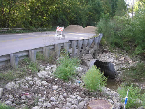
Fig 17. This is the washed out culvert.
The third area of flooding surveyed was in a subdivision in an unincorporated area just south of Algonquin, Illinois. The flooded area was south of

Fig 18. Along Winakai Drive, The river is in the background.

Fig 19. Winakai Drive

Fig 20. A house on Winakai Drive.
The dam at Algonquin along route 62 was overtopped with water flowing over the dam. The gate was wide open. A city park south of the dam and on the west side of the river was flooded, as the picture shows. One can see the water was high enough to top the dam.

Fig 21. Algonquin Dam with the gates open.

Fig 22. Flooded Park at Algonquin Dam in Algonquin.
On the