
Science Wednesday: Mapping Forest “Fuels”
Posted on November 19th, 2008 - 10:30 AM Each week we write about the science behind environmental protection. Previous Science Wednesdays.
About the author: Todd Erdody is a MS student at the University of Washington College of Forest Resources. His work is funded by an EPA Science to Achieve Results (STAR) Graduate Research Fellowship.
 Before starting my graduate education in the fall of 2007, I was working as a fire monitor and firefighter in Sequoia and Kings Canyon National Parks in California. I was headed for a graduate program in remote sensing and forestry with a college-funded fellowship and no set thesis topic. I spent a good part of that summer thinking about potential research topics as I ignited prescribed fires and fought, monitored, and mapped wildfires.
I realized that I wanted to build on existing research at the University of Washington to find better ways to estimate canopy “fuels”— small-diameter branches and foliage (leaves) that will burn in a wildfire.
Existing fuels maps are made from coarse-resolution vegetation maps and satellite imagery. By using high-resolution, remote sensing data such as LiDAR (Light Detection and Ranging) and digital imagery, perhaps canopy fuels could be mapped more accurately and efficiently. Through improved fuels mapping, smoke and harmful particulate matter production from wildfires could be more accurately assessed.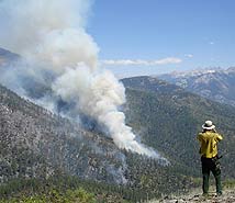
Since I was only funded for my first year of graduate school, I was looking for assistance. I was very grateful to receive the EPA STAR fellowship for the 2008/2009 academic year. Aside from helping me in my second year of graduate education and enabling me to focus on my work, it gives me the resources needed to attend a variety of conferences to present my research.
I wanted to focus my research on a fire-prone ecosystem, so I chose to work in the forests dominated by Ponderosa pines in eastern Washington State. I am currently building regression models for canopy fuel metrics and will eventually produce maps of canopy fuel loading. My goal is to be able to use these models in similar forest types throughout the Northwest.
Others have done similar work in the forests of western Washington and, although I am using existing methods, the real difference is that I am creating models in ecosystems that will frequently burn. The applications for this research are far-reaching in terms of both geography and planning. I envision forest managers using high-resolution remote sensing technologies to map fuels more effectively and create maps for use in wildfire and smoke modeling programs.
Tags: fire, forestry, fuel maps
| Permalink | TrackBack
November 25th, 2008 at 8:26 am
As a consulting forester in SC I can tell you on most private land prescribed burning is no longer being done due to smoke complaints and liability. Your study may be helpful in that problem.
[Reply]
November 25th, 2008 at 8:05 pm
For more information on my research and the Remote Sensing and Geospatial Analysis Laboratory at UW, please visit:
http://depts.washington.edu/rsgal/
[Reply]