|
Sediment Transport Research and Sidescan-Sonar Surveying in the Grand Canyon
 |
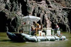
On the Colorado River: The inflatable boat (snout rig) used for the sidescan-sonar operation
along the Colorado River. An aluminum frame mounted to the inner
frame of the boat facilitated the deployment and retrieval of the
sidescan-sonar fish (not visible in the photo). White boxes housed
the electronics used in the operation. Umbrellas served to keep
electronics and scientists cool. Overall length of the boat is
22 ft. (7.5 m).
|
Dave Rubin, Hank Chezar, and colleagues from the Water Resources Divison
(WRD) in Denver and Glen Canyon Monitoring and Research Center (GCMRC)
in Flagstaff, Arizona, joined forces on the Colorado River last month.
First, they investigated sediment-transport dynamics using underwater
video, a current meter, and sediment sampling above Lee's Ferry,
Arizona. Then, between May 25th and June 5th they conducted a
successful sidescan-sonar survey along the first 240 miles of the
Colorado River in Grand Canyon, from Glen Canyon Dam to Diamond Creek.
Personnel from CMG and WRD, Denver, teamed up as part of GCMRC's ongoing
program of monitoring sediment distribution and grain-size variability
in Grand Canyon. The intrepid sidescan-sonar crew, responsible for
collecting the best data set to date, consisted of Carol Reiss, Mike
Hamer, Dave Hogg, and
Roberto Anima. Bob Bohannon took the lead in the
sediment sampling part of the cruise. Variable weather, with high
and fast water conditions and unforeseen events, combined to make this
a memorable cruise.
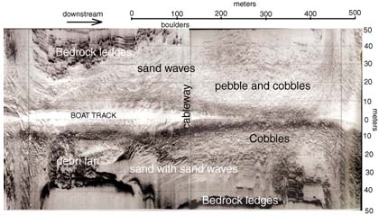 Section of sidescan-sonar data collected approximately 1 kilometer above
the Little Colorado River. The data cover 50 meters on each side of the
boat track, showing the variation in bottom types and the high resolution
of the imagery. Sidescan-sonar data were collected from Glen Canyon Dam
to Diamond Creek, a distance of 240 miles.
Section of sidescan-sonar data collected approximately 1 kilometer above
the Little Colorado River. The data cover 50 meters on each side of the
boat track, showing the variation in bottom types and the high resolution
of the imagery. Sidescan-sonar data were collected from Glen Canyon Dam
to Diamond Creek, a distance of 240 miles. |
|
 |
 July 1999
in this issue:
 cover story:
Grand Canyon
Gulf of Mexico Cruise
Georges Bank Benthic Habitat
Channel Islands
Lake Mead
Cruise News: R/V Gilbert
Great Bahama Bank
 Nat'l Ocean Sciences Bowl
 FL-AL-MS Geological Surveys
North Carolina Co-op
North East Mapping Organization
Atlantic Offshore Minerals Assessment
 WHFC Staff News
Visitors
New Staff
 July Publications List
|

