A collection vintage Illinois maps.
Historical Maps
Historical State Maps - Early 1800's maps, proposed travel routes etc.
1818 Map of Illinois - Constructed from the surveys in the General Land Office and other documents by John Melish.
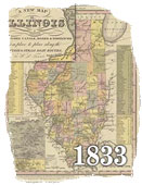
1833 Map of Illinois - Illinois map with proposed canals, roads and distances. Also included are stage and steamboat routes.
Territorial and Multi-State Maps - Maps of the midwest including Iowa, Illinois and Missouri.
1778 Territorial Map - Provides extensive information about rivers, lakes, terrain etc. The map also provides some wildlife information such as the location of herds of buffalo.
Illinois Railroad Maps - Railroad routes in Illinois.
1855 Railway Map Guide for Illinois showing all railway stations.
River Maps - Early 1800's map showing information about river passages and the land surrounding the Mississippi.
Mississippi River Map part A
Mississippi River Map part B
Past Illinois DOT Maps - The history of Illinois DOT maps. Vintage DOT map covers and more.
Historical and Vintage Map Links


 A
collection vintage Illinois maps.
A
collection vintage Illinois maps.