click on thumbnail for "user-friendly" medium-size image ...
medium-size images are around 100 K and best for web viewing ...
large-size images are 4-8 M, scanned images, no logo, 300 dpi, 8x10 to 9x12 size, and good for printing and publication ...
MSH80_small_ash_plume_10-10-80.jpg Steam and ash plume rises over Mount St. Helens' east crater rim. Shoestring Glacier is visible on the left.
USGS Photograph taken on October 10, 1980, by Lyn Topinka.
[medium size] ...
[large size]
MSH82_st_helens_plume_from_harrys_ridge_05-19-82.jpg Plumes of steam, gas, and ash often occured at Mount St. Helens in the early 1980s. On clear days they could be seen from Portland, Oregon, 50 miles (81 kilometers) to the south. The plume photographed here rose nearly 3,000 feet (1,000 meters) above the volcano's rim. The view is from Harrys Ridge, five miles (8 kilometers) north of the mountain.
USGS Photograph taken on May 19, 1982, by Lyn Topinka.
[medium size] ...
[large size] ...
[TIF Format, 20 M] ...
MSH82_st_helens_spirit_lake_reflection_05-19-82.jpg Mount St. Helens and the devastated area is now within the 110,000-acre Mount St. Helens National Volcanic Monument, under jurisdiction of the United States Forest Service. Visitor centers, interpretive areas, and trails are being established as thousands of tourists, students, and scientists visit the monument daily. Mount St. Helens is once again considered to be one of the most beautiful and interesting of the Cascade volcanic peaks.
USGS Photograph taken on May 19, 1982, by Lyn Topinka.
[medium size] ...
[large size] ...
[TIF Format, 18 M] ...
[TIF Format, 48 M]
MSH83_st_helens_with_ash_steam_plume_04-04-83.jpg Ash and steam plume at Mount St. Helens, as seen from the Pumice Plain.
USGS Photograph taken on April 4, 1983, by Pat Pringle.
[medium size] ...
[large size]
MSH83_ash_steam_plume_from_dome_04-29-83.jpg Small ash and steam plume from top of Mount St. Helens dome. View from the south crater floor.
USGS Photograph taken on April 29, 1983, by Lyn Topinka.
[medium size] ...
[large size] ...
[TIF Format, 24 M]
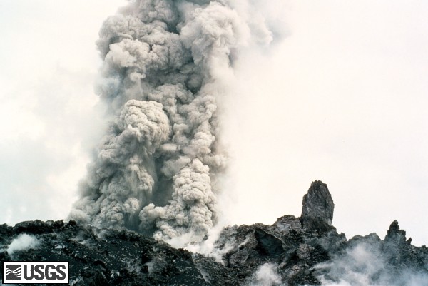
MSH83_ash_steam_plume_from_dome_closeup_04-29-83.jpg Closeup of small ash and steam plume from top of Mount St. Helens dome. View from the south crater floor.
USGS Photograph taken on April 29, 1983, by Lyn Topinka.
[medium size] ...
[large size] ...
[TIF Format, 24 M]
 Use of CVO Material and Copyright Information