click on thumbnail for "user-friendly" medium-size image ...
medium-size images are around 100 K and best for web viewing ...
large-size images are 4-8 M, scanned images, no logo, 300 dpi, 8x10 to 9x12 size, and good for printing and publication ...
MSH80_bear_tracks_in_ash_and_pumice_october_1980.jpg Animals also made a comeback soon after the May 18, 1980 eruption. Many smaller animals, such as gophers, mice, frogs, fish, and insects were hibernating below ground or under water on May 18, 1980, and they survived the blast. Larger animals such as bear (whose tracks are shown here), elk, deer, and coyotes have been moving back into the area as their food supplies increase. A mountain goat has even been spotted high on the flanks of the volcano.
USGS Photograph taken in October 1980, by Lyn Topinka.
[medium size] ...
[large size] ...
[TIF Format, 22 M]
MSH84_st_helens_from_harrys_ridge_fireweed_august_1984.jpg Fireweed is one species of plantlife which has returned to Mount St. Helens' devastated area. Vegetation began reappearing as early as the summer of 1980 as many small trees and plants were protected by the snowpack on May 18. Seeds, carried by the wind or by animals, also entered the area and grew. By 1985, the ridges surrounding the volcano were covered with new growth.
USGS Photograph taken in August 1984, by Lyn Topinka.
[medium size] ...
[large size]
MSH84_fireweed_on_harrys_ridge_with_spirit_lake_09-04-84.jpg Fireweed, with Spirit Lake in the background. View from Harrys Ridge.
USGS Photograph taken in September 4, 1984, by Lyn Topinka.
[medium size] ...
[large size]
MSH86_smith_creek_drainage_looking_north_06-86.jpg Smith Creek drainage looking north.
USGS Photograph taken in June 1986, by David Wieprecht.
[medium size] ...
[large size]
MSH86_new_growth_smith_creek_june_1986.jpg New growth in Smith Creek drainage.
USGS Photograph taken in June 1986, by David Wieprecht.
[medium size] ...
[large size]
MSH89_regrowth_north_fork_toutle_05-15-89.jpg New growth, North Fork Toutle River drainage.
USGS Photograph taken in May 15, 1989, by Lyn Topinka.
[medium size] ...
[large size]
MSH05_aerial_view_debris_avalanche_07-13-05.jpg Aerial view of Mount St. Helens' 1980 debris avalanche.
USGS Photograph taken on July 13, 2005, by John Pallister.
[medium size] ...
[large size]
MSH05_aerial_hillsides_and_debris_avalanche_07-13-05.jpg Aerial view of Mount St. Helens' 1980 debris avalanche.
USGS Photograph taken on July 13, 2005, by John Pallister.
[medium size] ...
[large size]
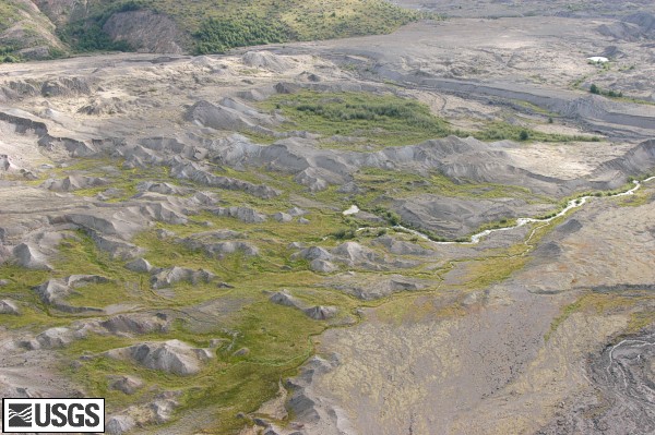
MSH05_aerial_debris_avalanche_new_growth_07-13-05.jpg Aerial view of Mount St. Helens' 1980 debris avalanche with new growth.
USGS Photograph taken on July 13, 2005, by John Pallister.
[medium size] ...
[large size]
MSH05_carbonate_springs_07-26-05.jpg Regrowth, Carbonate Springs, located on the Pumice Plain, approximately 4 miles north and west of Mount St. Helens' Crater.
USGS Photograph taken on July 26, 2005 by Ken McGee.
[medium size] ...
[large size]
MSH05_carbonate_springs_regrowth_07-26-05.jpg Regrowth, Carbonate Springs, located on the Pumice Plain, approximately 4 miles north and west of Mount St. Helens' Crater.
USGS Photograph taken on July 26, 2005 by Ken McGee.
[medium size] ...
[large size]
MSH05_aerial_st_helens_from_toutle_valley_08-26-05.jpg Aerial view, Mount St. Helens from the west, with the North Fork Toutle River valley in the foreground.
USGS Photograph taken on August 26, 2005 by Kurt Spicer.
[medium size] ...
[large size]
 Use of CVO Material and Copyright Information