
 Feeds & Data
Magnitude 6.1 - COSTA RICA
2009 January 08 19:21:34 UTC
Earthquake Details
| Magnitude | 6.1 |
|---|---|
| Date-Time |
|
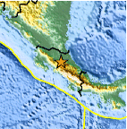
| Location | 10.197°N, 84.159°W |
| Depth | 4.5 km (2.8 miles) set by location program |
| Region | COSTA RICA |
| Distances | 30 km (20 miles) NNW of SAN JOSE, Costa Rica 80 km (50 miles) ENE of Puntarenas, Costa Rica 120 km (75 miles) SE of San Carlos, Nicaragua 1770 km (1100 miles) SSW of Miami, Florida |
| Location Uncertainty | Error estimate not available |
| Parameters | NST=222, Nph=223, Dmin=31 km, Rmss=0 sec, Gp= 61°, M-type=regional moment magnitude (Mw), Version=R |
| Source |
|
| Event ID | us2009bpba |
- This event has been reviewed by a seismologist.
- Did you feel it? Report shaking and damage at your location. You can also view a map displaying accumulated data from your report and others.
Earthquake Summary

Felt Reports
At least 20 people killed in the Cinchona-Dulce Nombre area. Many of the casualties were caused by landslides. Many people were injured, several buildings were damaged and landslides blocked roads in the area. Electricity was disrupted in parts of San Jose. Felt (VI) at Asuncion, Grecia and San Pablo; (V) at Alajuela, Colon, Curridabat, Desamparados, Escazu, Guadalupe, Heredia, Mercedes, Quesada, Sabanilla, San Antonio, San Francisco, San Isidro, San Jose, San Juan, San Pedro, San Rafael, Santa Ana and Santo Domingo; (IV) at Atenas, Cartago, San Ramon, and Tres Rios; (III) at Jacao. Felt throughout Costa Rica and in southern and central Nicaragua.
Tectonic Summary
The Costa Rican earthquake of January 8th, 2009 occurred within the Caribbean plate just east of its surface boundary with the Cocos plate. The earthquake has a strike-slip mechanism and likely resulted from the release of stresses built up within the crust of the Caribbean plate as the Cocos plate subducts beneath it. The plates converge at a rate of about 75 mm/year and the Cocos subducted slab dips to the northeast at around 45° to a depth of 170 km.

Cocos subduction has been responsible for a tremendous amount of
historically damaging earthquakes in Central America. In 1776, an
earthquake in Santiago, Guatemala, left 20,000 dead, destroyed 3,000
buildings and forced the colonial capital of Central America to be moved.
In 1931, a M6.0 earthquake in Managua, Nicaragua, killed 2,000 people. In
1972, another earthquake in Managua with M6.2 left approximately 5,000
dead, 20,000 injured and 250,000 homeless. The 1976 M7.5 Motagua
earthquake in Guatemala claimed 23,000 lives and injured 76,000 more. This
event took place along the Motagua fault zone, which acts as the active
transform boundary between the Caribbean and South America plates. In 1986,
a M5.5 earthquake killed 1,000 people in El Salvador. The 1991 M7.6
earthquake in Costa Rica killed 47 people and injured 109 more. In 1992 a
M7.6 earthquake in Nicaragua killed at least 116 people. Most damage and
casualties were a result of a tsunami triggered by the earthquake. In January
of 2001, a M7.7 earthquake southwest of San Miguel, El Salvador killed 852
people and damaged 150,000 buildings. Extensive landsliding was
responsible for most of the deaths and damage associated with this event.
One month later, to the day, a M6.6 earthquake took 315 lives in the San
Juan Tepezontes-San Vicente-Cojutepeque area in El Salvador.
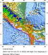
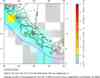
Earthquake Maps


Scientific & Technical Information

- Preliminary Earthquake Report
- U.S. Geological Survey, National Earthquake Information Center:
World Data Center for Seismology, Denver
