|
! Converted to time format with year at start.
|
|
!
|
|
DATA COLLECTION OVERVIEW (use NGDC GEODAS CD to retrieve data)
|
|
|
|
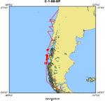
MCG Data Collection ID --- C188SP
|
|
Institution Data Collection ID --- C2901
|
|
NGDC ID --- 01010288
|
|
Funding --- (unspecified)
|
|
Project, Cruise & Leg --- (unspecified)
|
|
Study region --- -32.00000,-54.00000, -77.00000, -70.00000
|
|
Chief Scientist(s) --- STEVEN CANDE, STEPHEN LEWIS
|
|
Name of vessel --- R/V Robert D. Conrad (surface ship)
|
|
Date field data collection started --- 01/07/88 VALPARAISO, CHILE
|
|
Date field data collection ended --- 02/10/88 PUNTA ARENAS, CHILE
|
|
Parameters surveyed ---
|
|
Bathymetry: surveyed, contained in data file
|
|
Magnetics: surveyed, contained in data file
|
|
Gravity: surveyed, contained in data file
|
|
High-resolution seismics: not surveyed
|
|
Deep penetration seismics: surveyed, but not contained in data file
|
|
Format --- (I1,A8,F5.2,4I2,F5.3,F8.5,F9.5,I1,F6.4,F6.1,I2,i1,3F6.1,I1,F5.1,F6.0,F7.1,F6.1,F5.1,A8,4I1)
|
|
Date of data input to NGDC --- 02/18/90
|
|
Contributing institution --- Lamont-Doherty Geological Observatory
|
|
Country --- United States of A
|
|
|
|
Navigation instrumentation --- FURUNO,TRANSIT SAT,GPS
|
|
Position determination method --- FURUNO DR BETWEEN SAT FIXES
|
|
|
|
Bathymetry instrumentation --- GENERL INSTRMNTS SEABEAM CENTER BEAM
|
|
Additional forms of bathymetric data --- SWATH ALSO COLLECTED BY URI
|
|
General rate of bathymetry in file --- 1.0 minutes
|
|
General collection rate of bathymetry --- 1 each 6 sec
|
|
Assumed sound velocity --- 1500.0 m/sec
|
|
Bathymetric datum code --- No correction applied (sea level)
|
|
Bathmetry interpolation scheme --- LOGGED ALL CNTR BEAM,CLOSEST TO 0 SECS. INTERP
|
|
|
|
Magnetics instrumentation --- VARIAN V75 MAGNETOMETER
|
|
Additional forms of magnetics data --- (unspecified)
|
|
General rate of magnetics in file --- 1.0 minutes
|
|
General collection rate of magnetics --- 20 seconds
|
|
Magnetic sensor tow distance --- (unspecified)
|
|
Magnetic sensor depth --- (unspecified)
|
|
Two sensor horizontal separation --- (unspecified)
|
|
Residual magnetics reference field --- IGRF-85
|
|
Method of applying residual field --- BILINEAR INTERP IN 1 DEG SQUARE
|
|
|
|
Gravity instrumentation --- BELL AEROSPACE BGM-3 GRAVITY METER
|
|
Additional forms of gravity data --- (unspecified)
|
|
General rate of gravity in file --- 1.0 minutes
|
|
General collection rate of gravity --- (unspecified)
|
|
Theoretical gravity formula --- INTERNATIONAL 80
|
|
Reference system --- Potsdam system
|
|
Corrections applied --- +.0328 MGAL/DAY, DC +.57 MGAL
|
|
Starting land tie --- 978030.0 NOAA SHIP BASE NO.2,MIAMI,1/7/87
|
|
Ending land tie --- 981326.2 PORT ADMIN BLDG,P. ARENAS,2/13/S
|
|
|
|
Seismic instrumentation --- DIGICON DSS-240
|
|
Formats of seismic data --- (unspecified)
|
|
|
|
Notes ---
|
|
THEORETICAL GRAVITY FORMULA: Yo = 978.0327 * ( 1 + a - b ) where
|
|
b = .0000058 * sin( 2 * theta ) * sin( 2 * theta ) .
|
|
NGDC has multibeam bathymetric data for this cruise, however the tracklines
|
|
found here in GEODAS may not exactly correspond to the multibeam data.
|