|
|
|
Metadata
|
|
ID
|
P-9-69-SF
|
|
Abstract
|
United States Geological Survey, Menlo Park,
California,United States Geological Survey, Water Resources
Division. Chief Scientists: Dave McCulloch, Paul Carlson,
Dave Peterson. Geophysical data (sparker, waterbottle, grab,
Secchidisc, tempsalinometer, planktonnet) of field activity
P-9-69-SF in San Francisco Bay from 06/12/1969 to 06/13/1969
|
|
Organization
|
United States Geological Survey, Menlo Park, California
United States Geological Survey, Water Resources Division
|
|
Chief Scientist
|
Dave McCulloch
Paul Carlson
Dave Peterson
|
|
Activity Type
|
Geophysical
|
|
Platform
|
Polaris I
|
|
Area of Operation
|
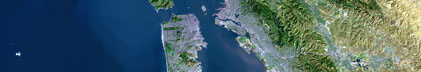
San Francisco Bay
|
|
Location map
|

|
|
Bounding Coordinates
|
38.25000
-123.25000 -121.25000
37.25000
|
|
Ports
|
leave Redwood City, CA
arrive Redwood City, CA
|
|
Dates
|
06/12/1969 (JD 163) to 06/13/1969 (JD 164)
|
|
Analog Materials
|
list
|
|
Index map

|
|
|
Information Specialist
|
|
|
Crew
|
|
Dave McCulloch
|
Chief Scientist, USGS Western Region
|
|
Dave Peterson
|
Chief Scientist, USGS Western Region
|
|
Paul Carlson
|
Chief Scientist, USGS Western Region
|
|
|
Equipment Used
|
|
sparker
|
|
waterbottle
|
|
grab
|
|
Secchidisc
|
|
tempsalinometer
|
|
planktonnet
|
|
|
Purpose
|
|
Seismic profiling and geochemistry of the San Francisco Bay.
|
|
|
Information to be Derived
|
|
Seismic reflection profiles, water data, temperature, salinity,
|
|
sedimentation, grain size analyses, plankton data.
|
|
|
Got Help?
|
For P-9-69-SF, we would appreciate any information on -- contract, days at sea, dive count, funding, kms of navigation, national plan, NGDC Info, notes, owner, project, project number, publications, scanned materials, seismic description, station count, station description, submersible, summary, tabulated info.
|
|