|
|
|
Metadata
|
|
ID
|
S-2-77-EG
|
|
Abstract
|
Chief Scientists: Gary Winkler, George Plafker. Data
(12khz, 3dot5khz, gravity, tempsalinometer,
integratednavigation, miniranger, dartcore, chaindredge,
uniboom, airgun) of field activity S-2-77-EG in Eastern Gulf
of Alaska from 06/05/1977 to 06/15/1977
|
|
Chief Scientist
|
Gary Winkler
George Plafker
|
|
Platform
|
Sea Sounder
|
|
Area of Operation
|
Eastern Gulf of Alaska
|
|
Location map
|
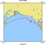
|
|
Bounding Coordinates
|
59.54720
-152.48824 -135.38438
57.07890
|
|
Ports
|
leave Sitka, AK
arrive Kodiak, AK
|
|
Dates
|
06/05/1977 (JD 156) to 06/15/1977 (JD 166)
|
|
Analog Materials
|
list
|
|
Index map

|
|
|
Information Specialist
|
|
|
Crew
|
|
Al McClenaghan
|
Ship Captain
|
|
Andy Stevenson
|
Mechanical Technician, USGS Western Region
|
|
Gary Winkler
|
Chief Scientist, USGS Western Region
|
|
George Plafker
|
Chief Scientist, USGS Western Region
|
|
Harry Hill
|
Electronics Technician, USGS Western Region
|
|
Howard Sheppard
|
Chief Engineer, USGS Western Region
|
|
Jack Hampson
|
Watchstander, USGS Western Region
|
|
Jeff Rupert
|
Watchstander, USGS Western Region
|
|
John Dunleauey
|
Navigator, USGS Western Region
|
|
John Saladin
|
Electronics Technician, USGS Western Region
|
|
Ornulf Johannessen
|
Chief Mate, USGS Western Region
|
|
Paula Quinterno
|
Dafe Curator, USGS Western Region
|
|
Paula Shryrock
|
Navigator, USGS Western Region
|
|
Rich Garlow
|
Navigator, USGS Western Region
|
|
Roland Brady
|
Mechanical Technician, USGS Western Region
|
|
Sue Hunt
|
Dafe Curator, USGS Western Region
|
|
Susan Winkler
|
Watchstander, USGS Western Region
|
|
Warren Coonrad
|
Watchstander, USGS Western Region
|
|
|
Equipment Used
|
|
12khz
|
|
3dot5khz
|
|
gravity
|
|
tempsalinometer
|
|
integratednavigation
|
|
miniranger
|
|
dartcore
|
|
chaindredge
|
|
uniboom
|
|
airgun
|
|
|
NGDC Overview
|
|
! Converted to time format with year at start.
|
|
!
|
|
DATA COLLECTION OVERVIEW (use NGDC GEODAS CD to retrieve data)
|
|
|
|
MCG Data Collection ID --- S277EG
|
|
Institution Data Collection ID --- S277EG
|
|
NGDC ID --- 06110014
|
|
Funding --- (unspecified)
|
|
Project, Cruise & Leg --- Gary Winkler
|
|
Study region --- +60.00000,+57.00000,-153.00000,-135.00000
|
|
Chief Scientist(s) --- George Plafker
|
|
Name of vessel --- Sea Sounder (surface ship)
|
|
Date field data collection started --- 06/05/77 LV SITKA,AK
|
|
Date field data collection ended --- 06/15/77 AR KODIAK
|
|
Parameters surveyed ---
|
|
Bathymetry: surveyed, contained in data file
|
|
Magnetics: (unspecified)
|
|
Gravity: (unspecified)
|
|
High-resolution seismics: (unspecified)
|
|
Deep penetration seismics: (unspecified)
|
|
Format --- (I1,A8,F5.2,4I2,F5.3,F8.5,F9.5,I1,F6.4,F6.1,I2,i1,3F6.1,I1,F5.1,F6.0,F7.1,F6.1,F5.1,A8,4I1)
|
|
Date of data input to NGDC --- 05/21/87
|
|
Contributing institution --- USGS Branch of Pacific Marine Geology
|
|
Country --- United States
|
|
|
|
Navigation instrumentation --- MINIRANGER SHIPBOARD INT. NAV. SYS.
|
|
Position determination method --- (unspecified)
|
|
|
|
Bathymetry instrumentation --- 12 KHZ BATHYMETRY 3.5 KHZ BATHYMETRY
|
|
Additional forms of bathymetric data --- (unspecified)
|
|
General rate of bathymetry in file --- 1.5 minutes
|
|
General collection rate of bathymetry --- (unspecified)
|
|
Assumed sound velocity --- (unspecified)
|
|
Bathymetric datum code --- No correction applied (sea level)
|
|
Bathmetry interpolation scheme --- (unspecified)
|
|
|
|
Magnetics instrumentation --- (unspecified)
|
|
Additional forms of magnetics data --- (unspecified)
|
|
General rate of magnetics in file --- (unspecified)
|
|
General collection rate of magnetics --- (unspecified)
|
|
Magnetic sensor tow distance --- (unspecified)
|
|
Magnetic sensor depth --- (unspecified)
|
|
Two sensor horizontal separation --- (unspecified)
|
|
Residual magnetics reference field --- (unspecified)
|
|
Method of applying residual field --- (unspecified)
|
|
|
|
Gravity instrumentation --- (unspecified)
|
|
Additional forms of gravity data --- (unspecified)
|
|
General rate of gravity in file --- (unspecified)
|
|
General collection rate of gravity --- (unspecified)
|
|
Theoretical gravity formula --- (unspecified)
|
|
Reference system --- (unspecified)
|
|
Corrections applied --- (unspecified)
|
|
Starting land tie --- (unspecified)
|
|
Ending land tie --- (unspecified)
|
|
|
|
Seismic instrumentation --- SINGLE CHANNEL SEISMIC BLEW 4 CAPACITORS
|
|
Formats of seismic data --- IN ALL
|
|
|
Publications
|
|
Plafker, George, Winkler, Gary R., Hunt, Susan J., Bartsch-Winkler, Susan, Coonrad, Warren L.,
|
|
Quinterno, Paula, 1978, Outcrop samples from the continental slope in the eastern Gulf of Alaska:
|
U.S. Geological Survey Circular 0772-B, p. B97-B101.
|
|
|
Got Help?
|
For S-2-77-EG, we would appreciate any information on -- activity type, contract, days at sea, dive count, funding, information to be derived, kms of navigation, national plan, notes, organization, owner, project, project number, purpose, scanned materials, seismic description, station count, station description, submersible, summary, tabulated info.
|
|