
 Feeds & Data
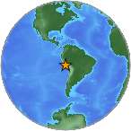
Magnitude 8.0 - NEAR THE COAST OF CENTRAL PERU
2007 August 15 23:40:57 UTC
Earthquake Details
| Magnitude | 8.0 |
|---|---|
| Date-Time |
|
| Location | 13.354°S, 76.509°W |
| Depth | 39 km (24.2 miles) set by location program |
| Region | NEAR THE COAST OF CENTRAL PERU |
| Distances | 50 km (30 miles) W of Chincha Alta, Peru 110 km (70 miles) NW of Ica, Peru 150 km (95 miles) SSE of LIMA, Peru 210 km (130 miles) SW of Huancayo, Peru |
| Location Uncertainty | horizontal +/- 5.2 km (3.2 miles); depth fixed by location program |
| Parameters | NST=275, Nph=275, Dmin=155 km, Rmss=0.84 sec, Gp= 29°, M-type=moment magnitude (Mw), Version=9 |
| Source |
|
| Event ID | us2007gbcv |
- This event has been reviewed by a seismologist.
- Did you feel it? Report shaking and damage at your location. You can also view a map displaying accumulated data from your report and others.
Earthquake Summary

The following is a release by the United States Geological Survey, National Earthquake Information Center: An earthquake occurred NEAR THE COAST OF CENTRAL PERU, about 45 km (25 miles) west-northwest of Chincha Alta or about 145 km (90 miles) south-southeast of Lima at 5:40 PM MDT, Aug 15, 2007 (6:40 PM local time in Peru).
Felt Reports
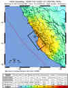
At least 514 people killed and 1090 injured. More than 35,500 buildings destroyed and more than 4200 buildings damaged. The majority of the damage and casualties occurred in Chincha Alta, Ica and Pisco. Widespread communications and power outages occurred in the area. The Panamerican Highway, the Carretera Central and other main transport routes suffered heavy damage due to landslides and cracks. Felt (VIII) at Chincha Alta; (VI) at Lima, (V) at Cusco, (IV) at Arequipa and (III) at Trujillo. Felt at Abancay, Ayacucho, Cajamarca, Chaclacayo, Chillca, Chimbote, Chosica, Cocachacra, Huacho, Huanuco, Huaraz, Huarmey, Ica, Imperial, La Oroya, Lambayeque, Mala, Nazca, Nuevo Imperial, Pachacamac, Quillabamba, Urubamba and Viru. Felt (III) at Bogota, Colombia and (II) at La Serena, Chile. Also felt at Coquimbo and Iquique, Chile; at Guayaquil and Quito, Ecuador; at La Paz, Bolivia and at Manaus, Brazil. Possible earthquake lights observed at Lima. Tsunami wave heights in centimeters at the following selected tide stations: 16 at Antofagasta, 36 at Arica, 23 at Caldera, 28 at Coquimbo, 16 at Iquique, 21 in Archipielago Juan Fernandez, 18 at San Antonio, 28 at San Felix, 35 at Talcahuano and 17 at Valparaiso, Chile; 27 at Galapagos Islands, Ecuador; 30 at Nuku Hiva Island, French Polynesia; 12 at Hanasaki and 13 at Tosa-Shimizu, Japan; 20 at Acapulco, Mexico; 30 at Chatham Island, 13 at Green Island, 25 at Kaikoura, 17 at Lyttelton, 22 at Sumner Head and 26 at Tinaru, New Zealand; 100 at Callao and La Punta, Peru; 13 at Apia, Samoa; 10 at Dutch Harbor, Alaska; 0.12 at Crescent City, California; 33 at Hilo, 28 at Kahului, 12 at Kawaihae, Hawaii, USA; 14 at Port Vila, Vanuatu.
Tectonic Summary
This earthquake occurred at the boundary between the Nazca and South American tectonic plates. The two plates are converging at a rate of 77 mm per year. The earthquake occurred as thrust-faulting on the interface between the two plates, with the South American plate moving up and seaward over the Nazca plate.
Coastal Peru has a history of very large earthquakes. The August 15 shock originated just south of the source region of the magnitude 8.1 earthquake of October 1974 and just north of the source regions of major earthquakes that occurred in August 1942 (magnitude 7.7) and 1996 (magnitude 7.7). The largest coastal Peru earthquake of the last two centuries was the magnitude 9 earthquake of 1868, which was centered about 700 km southeast of the August 15 earthquake. The 1868 shock produced a tsunami that killed several thousand people along the South American coast and also caused damage in Hawaii.

Earthquake Information for Peru
Earthquake Information for South America
4-minute field survey video filmed from September 15-21, 2007
Earthquake Maps


Scientific & Technical Information

Additional Information, News Reports
- Preliminary Earthquake Report
- U.S. Geological Survey, National Earthquake Information Center:
World Data Center for Seismology, Denver
