
 Feeds & Data
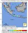
Magnitude 7.5 - JAVA, INDONESIA
2007 August 08 17:04:58 UTC
Earthquake Details
| Magnitude | 7.5 |
|---|---|
| Date-Time |
|
| Location | 5.968°S, 107.655°E |
| Depth | 289.2 km (179.7 miles) |
| Region | JAVA, INDONESIA |
| Distances | 110 km (65 miles) ENE of JAKARTA, Java, Indonesia 115 km (70 miles) N of Bandung, Java, Indonesia 135 km (85 miles) NW of Cirebon, Java, Indonesia 145 km (90 miles) NE of Sukabumi, Java, Indonesia |
| Location Uncertainty | horizontal +/- 8 km (5.0 miles); depth +/- 11.2 km (7.0 miles) |
| Parameters | NST=170, Nph=170, Dmin=545.1 km, Rmss=1.18 sec, Gp= 36°, M-type=moment magnitude (Mw), Version=7 |
| Source |
|
| Event ID | us2007fubd |
- This event has been reviewed by a seismologist.
- Did you feel it? Report shaking and damage at your location. You can also view a map displaying accumulated data from your report and others.
Earthquake Summary


The following is a release by the United States Geological Survey, National Earthquake Information Center: An earthquake occurred IN JAVA, INDONESIA, about 100 km (65 miles) E of JAKARTA or about 110 km (70 miles) N of Bandung at 11:04 AM MDT, Aug 8, 2007 (Aug 09 at 12:04 AM local time in Java, Indonesia). The magnitude and location may be revised when additional data and further analysis results are available. No reports of damage or casualties have been received at this time. Because this earthquake is located about 290 km below the surface of the earth, it will have been felt strongly over a wide area, but is not likely to cause severe damage. We have received reports that the earthquake was felt in much of Java and in parts of Malaysia.
Felt Reports
WP 7.4 (GS).
Tectonic Summary
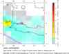
The earthquake of August 8, 2007, occurred at a depth of about 290 km within the lithosphere of the Australia plate, which is subducting beneath the Sunda plate. In this region, the Australia plate moves to the north with respect to the Sunda plate with a velocity of about 58 mm/yr. The Australia plate is thrust beneath the Sunda plate at the Java trench, south of the island of Java, and is subducted to progressively greater depths with distance north of the trench. The subducted lithosphere beneath and north of Java is seismically active to a depth of about 650 km.
Earthquakes that have focal-depths between 70 and 300 km are commonly termed “intermediate-depth” earthquakes, and earthquakes with focal-depths greater than 300 km are termed “deep-focus” earthquakes. Intermediate-depth and deep-focus earthquakes represent deformation within subducted plates, rather than deformation at plate boundaries. Intermediate-depth and deep-focus earthquakes typically cause less damage on the ground surface above their foci than is the case with similar magnitude shallow-focus earthquakes, but large intermediate-depth and deep-focus earthquakes may be felt at great distance from their epicenters.
Earthquake Information for Asia
Earthquake Information for Indonesia
 Tsunami Information
- West Coast & Alaska Tsunami Warning Center
- Pacific Tsunami Warning Center
- NOAA Tsunami Warning Center
- Recent Tsunamis
- Tsunami Information Links
The earthquake locations and magnitudes cited in these bulletins are very preliminary, and may disagree with the more accurate USGS locations and magnitudes computed using more extensive data sets.
Earthquake Maps


Scientific & Technical Information

- Preliminary Earthquake Report
- U.S. Geological Survey, National Earthquake Information Center:
World Data Center for Seismology, Denver
