Magnitude 8.6 - NORTHERN SUMATRA, INDONESIA - usweax
2005 March 28 16:09:36 UTC
A great earthquake occurred at 16:09:36 (UTC) on Monday, March 28, 2005.
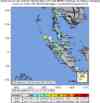
The magnitude 8.6 event has been located in NORTHERN SUMATRA, INDONESIA.
(This event has been reviewed by a seismologist.)
Earthquake Summary
Felt Reports
At least 1000 people killed, 300 injured and 300 buildings destroyed on Nias; 100 people killed, many injured and several buildings damaged on Simeulue; 200 people killed in Kepulauan Banyak; 3 people killed, 40 injured and some damage in the Meulaboh area, Sumatra. A 3-meter tsunami damaged the port and airport on Simeulue. Tsunami runup heights as high as 2 meters were observed on the west coast of Nias and 1 meter at Singkil and Meulaboh, Sumatra. Felt (VI) at Banda Aceh and (V) at Medan. At least 10 people were killed during evacuation of the coast of Sri Lanka. Felt (IV) along the west coast of Malaysia; (IV) at Bangkok and (III) at Phuket, Thailand; (III) at Singapore; (III) at Male, Maldives. The quake was also felt in the Andaman and Nicobar Islands, India and in Sri Lanka. Tsunami wave heights (peak to trough) recorded from selected tide stations: about 40 cm on Panjang, Indonesia; about 25 cm at Colombo, Sri Lanka; 40 cm on Hanimadu, 18 cm at Male and 10 cm at Gan, Maldives. Initial observations indicate about 1 meter of subsidence on the coast of Kepulauan Banyak as well as 1 meter of uplift on the coast of Simeulue. Seiches were observed on ponds in West Bengal, India.
Earthquake Information for ASIA
Earthquake Information for INDONESIA
Earthquake Details
| Magnitude |
8.6 |
| Date-Time |
Monday, March 28, 2005 at 16:09:36 (UTC)
= Coordinated Universal Time
Monday, March 28, 2005 at 11:09:36 PM
= local time at epicenter
Time of Earthquake in other Time Zones
|
| Location |
2.074°N, 97.013°E |
| Depth |
30 km (18.6 miles) set by location program |
| Region |
NORTHERN SUMATRA, INDONESIA |
| Distances |
205 km (125 miles) WNW of Sibolga, Sumatra, Indonesia
245 km (155 miles) SW of Medan, Sumatra, Indonesia
535 km (330 miles) WSW of KUALA LUMPUR, Malaysia
1410 km (880 miles) NW of JAKARTA, Java, Indonesia
|
| Location Uncertainty |
horizontal +/- 4 km (2.5 miles); depth fixed by location program |
| Parameters |
Nst=289, Nph=289, Dmin=537 km, Rmss=0.76 sec, Gp= 25°,
M-type=teleseismic moment magnitude (Mw), Version=R
|
| Source |
USGS NEIC (WDCS-D)
|
| Event ID |
usweax |
Earthquake Maps

Earthquake Location
Scientific & Technical Info
Additional Information, News Reports
- Preliminary Earthquake Report
- U.S. Geological Survey, National Earthquake Information Center
World Data Center for Seismology, Denver