Gulf Coast Impacts of Hurricanes Gustav and Ike Documented by USGS Extreme-Storms Group
October 2008
California Sea Otters: Population Recovery Continues at Slower Rate
September 2008
Scientists Map Unexplored Arctic Sea Floor
September 2008
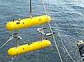
Tribal Canoes Towing Underwater Probes in the Salish Sea Attract Widespread Interest, Gather Valuable Water-Quality Data
September 2008
Cold-Water Corals, Habitats, and Paleoclimate in the Drake Passage, Southern Ocean
August 2008
Palos Verdes Shelf Experiment: What Will Happen to the Contaminated Mud?
July 2008
Palos Verdes Shelf Experiment: Whatever Can Go Wrong…
July 2008
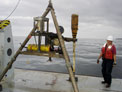
Gravity Coring Offshore Puerto Rico and the U.S. Virgin Islands to Investigate the Timing of Submarine Landslides and Large Earthquakes
July 2008
USGS Will Collaborate with Coast Salish Indigenous Peoples to Measure Water Quality in the Salish Sea (Puget Sound, Strait of Georgia, and Strait of Juan de Fuca)
May 2008
Calibrating Proxies for the Study of Holocene Climate Change in the Northern Gulf of Mexico
April 2008
Tar Balls from Southern California Seeps Appear on Central California Beaches
April 2008
USGS Researchers Participate in Research Cruise Studying Iron Biogeochemistry in the Gulf of Alaska
March 2008
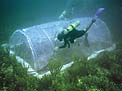
Sea-Floor Survey Off Key Largo, Florida, Using Along-Track Reef-Imaging System (ATRIS)
March 2008
USGS Researchers Lead International Team Investigating Damage Caused by Offshore Earthquake Near World's Largest Nuclear Power Plant in Japan
Jan. / Feb. 2008
USGS Scientists Investigate Coastal Processes Affecting a Restored Tidal Wetland in the San Francisco Presidio
Jan. / Feb. 2008
USGS Coral-Reef Investigation Featured in the Molokai Times
Jan. / Feb. 2008
Earthquake Swarms in the Puerto Rico Trench Monitored by Ocean-Bottom Seismometers
December 2007
Assessing the Resilience of a Vital Barrier-Island Chain—Chandeleur and Breton Islands, Louisiana
December 2007
Sea-Floor Mapping in the Gulf of Mexico Aboard the Research Vessel Bellows
November 2007
Mapping the Sea Floor Southwest of Santa Rosa Island, California
November 2007
USGS Researchers Collaborate with National Park Service Scientists to Understand the Impact of Watershed Erosion on Coral Reefs in War-in-the-Pacific National Historical Park, Guam
October 2007
Offshore Mapping Captures Tar Seeps in the Santa Barbara Channel, California
September 2007
California Sea Otters—2007 Survey Count Reaches New High
September 2007
Investigating Submarine Ground Water on Maryland's Eastern Shore
August 2007
New Bathymetric Map of Mona Passage, Northeastern Caribbean, Aids in Earthquake- and Tsunami-Hazard Mitigation
May 2007
Surveying Faults and Sediment Outside the Entrance to San Francisco Bay
March 2007
Studying Submarine Ground-Water Discharge at Dor Beach, Israel
March 2007
Satellites Help Scientists Track Migratory Birds: GPS Latest Tool in Fight Against Avian Influenza
Nov. / Dec. 2006
Effects of Urbanization on Nearshore Ecosystems in Puget Sound: Liberty Bay Pilot Study
Nov. / Dec. 2006
Studying the Elwha River, Washington, in Preparation for Dam Removal
Nov. / Dec. 2006
Massachusetts Sea-Floor Mapping Project Expands to South Shore and Cape Cod Bay
Nov. / Dec. 2006
Invasive Sea Squirts Persist on Georges Bank Fishing Grounds
October 2006
North to Alaska—an Aerial Shoreline Reconnaissance
October 2006
Oil-Spill Exercise Aims for Safe Seas, Protection of National Marine Sanctuaries
September 2006
Mapping the Sea Floor Off Santa Barbara, California
September 2006
Measuring Hurricane Impact—USGS Scientists Map the Louisiana Coastline
August 2006
Studying Submarine Ground-Water Discharge at Santa Barbara, California, and Hood Canal, Washington
August 2006
California Sea-Otter Numbers Dip Again in 2006, But Overall Population Trend Remains Up
August 2006
USGS Scientists Revisit New Orleans Levee Breaks to Collect High-Accuracy Survey Data
May 2006
Impressions of Post-Katrina New Orleans and Mississippi
May 2006
USGS Scientists Investigate Surf-Zone Hydrodynamics at San Francisco's Ocean Beach
April 2006
Eruption of Augustine Volcano Being Monitored by State-of-the-Art Submarine Seismometers
March 2006
USGS and Florida State University Scientists Collaborate on Submarine-Ground-Water-Discharge Study in the Northern Gulf of Mexico
March 2006
USGS Sea-Floor Mapping Group Assists Woods Hole Oceanographic Institution in Searching for Airplane Wreckage
March 2006
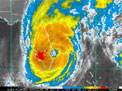
Monitoring Hurricane Wilma's Storm Surge
February 2006
USGS Scientists Investigate New Orleans Levees Broken by Hurricane Katrina
Dec. 2005 / Jan. 2006
Post-Katrina Cleanup in Biloxi, Mississippi—a Volunteer's Reflections
Dec. 2005 / Jan. 2006
USGS Scientists Examine Offshore Impacts of Hurricane Katrina
Dec. 2005 / Jan. 2006
USGS Diving Operations Assist Sediment-Toxicity Studies in Western Long Island Sound
Dec. 2005 / Jan. 2006
USGS, State of Massachusetts, and NOAA Cooperate to Map Sea-Floor Geology Off Massachusetts Coast
Dec. 2005 / Jan. 2006
Alvin Dives to Deep-Water Coral Habitats off New England
Dec. 2005 / Jan. 2006
New Equipment Deployed to Map Sea-Floor Geology in Southern Maine
November 2005
Sea Squirt Colonies Persist on Georges Bank—Found Over More Area, Less Abundant at Some Sites
November 2005
Measuring Hurricane Impacts—USGS Coastal Hazards Team Is Up to the Challenge
October 2005
Sonar Survey of Sea-Floor Habitats Southeast of Santa Barbara, California
October 2005
Drilling for Submarine Ground Water at Cape Cod National Seashore
October 2005
USGS Center in Lafayette, LA, Provides Aid in the Aftermath of Hurricane Katrina
September 2005
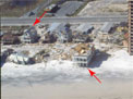
Before-and-After Aerial Photographs Show Coastal Impacts of Hurricane Katrina
September 2005
Hydrologic Impacts of Hurricane Dennis on the Florida Panhandle, July 9-14, 2005
September 2005
Along-Track Reef-Imaging System (ATRIS) Used to Survey the Sea Floor in Dry Tortugas National Park, Florida
September 2005
Finding the Needle in a Big Haystack—Locating Surf Scoter Nests in the Northern Boreal Forest
August 2005
USGS Researchers Lead a Collaborative Effort for Further Investigation of the Deep Coral Reef at Pulley Ridge
August 2005
California Sea Otters—2005 Survey Numbers Dip, But Overall Population Trend Remains Positive
August 2005
Coral Coring in Flower Garden Banks National Marine Sanctuary—a Collaborative Effort
July 2005
Joint Spanish-United States Cruise Investigates Tsunami and Earthquake Hazards in the Northeastern Caribbean
June 2005
Habitat Mapping to Assess Health of Oyster Fishery in Apalachicola Bay, Florida
June 2005
In Search of Submarine Ground-Water Discharge Along the Suwannee River Delta, Florida
June 2005
Paleoshorelines and Spawning Groupers—Deep Diving at the Shelf Edge, Northeastern Gulf of Mexico
May 2005
Second Tsunami Causes Damage in Indonesia—USGS Scientists Post Observations on the World Wide Web
April 2005
Why Wasn't There a Larger Tsunami from the Magnitude 8.7 March 28, 2005, Sumatra Earthquake?
April 2005
Assessing Tsunami Impacts in the Republic of Maldives
April 2005
Astonishing Wave Heights Among the Findings of an International Tsunami Survey Team on Sumatra
March 2005
USGS Flood-Response Teams Documented Effects of Hurricane Charley in Southwest-Central Florida in August 2004
March 2005
USGS Geologist Invited to Map Tsunami Impacts in the Maldives
March 2005
Mapping Oyster Beds in Apalachicola Bay, FL
March 2005
USGS Research Vessel G.K. Gilbert Helps Secure Super Bowl XXXIX
March 2005
USGS Scientists Study Sediment Deposited by 2004 Indian Ocean Tsunami
February 2005
Mapping the Sea Floor on the San Pedro Shelf, Southern California
February 2005
Indian Ocean Earthquake Triggers Deadly Tsunami
Dec. 2004 / Jan. 2005
Could It Happen Here? Tsunamis That Have Struck U.S. Coastlines
Dec. 2004 / Jan. 2005
Deltaic Habitats in Puget Sound—Natural Versus Human-Related Change
Dec. 2004 / Jan. 2005
Invasive Sea Squirt Alive and Well on Georges Bank
Dec. 2004 / Jan. 2005
Ripples for Everyone!—Investigating How Sediment Moves on the Sea Floor
Dec. 2004 / Jan. 2005
Sediment Impacts on Reef Corals in Maui, Hawai'i
November 2004
Putting Radon to Work: Identifying Coastal Ground-Water Discharge Sites
November 2004
Mapping Benthic Habitat Around Oil Platforms in the Santa Barbara Channel, California
November 2004
USGS Scientists Gather Images and Information About Recent Hurricanes
October 2004
Drilling Monitoring Wells in Dry Tortugas National Park—Fahrenheit 100, Blue Sky, Blue Water, Crumbling Bricks, and Here Comes Hurricane Charley
October 2004
Persistence of Coral Reefs Under Extreme Environmental Stress in American Samoa
October 2004
USGS Dive Team Completes Installation and Recovery of Samplers in Ashumet Pond, Falmouth, MA
October 2004
Eelgrass in Puget Sound—A New Study of Flow, Sediment Transport, and Zostera marina
September 2004
Microbial Ecology of Deepwater Corals in the Aleutian Islands
September 2004
Hyperspectral Data Analysis for Mapping Coastal Landslide Hazards Along the Big Sur Coast
September 2004
Ground-Truthing Sea-Floor Data with the New Mini SEABOSS—Mapping the South Essex Ocean Sanctuary
August 2004
USGS and WHOI Investigate Gas-Hydrate Mounds on the Gulf of Mexico Sea Floor
August 2004
California Margin's Ancient Volcanic History—MBARI Cruise to California Seamounts
August 2004
Exciting New Discoveries in Submarine Hydrothermal Systems, Commonwealth of the Northern Mariana Islands
July 2004
USGS Woods Hole Dive Team Deploys Samplers for Study of a Phosphorus Plume
July 2004
California Sea-Otter Numbers Climb for Second Consecutive Year
July 2004
Researchers Study Benthic Habitats in Glacier Bay, Alaska
June 2004
Integrated Science Team Deploys New Tools to Study Submarine Ground Water in North Carolina
June 2004
Coastal Landforms and Historical Shoreline Change on the West Coast of Hawai'i
May 2004
Microbial Life in Perennially Ice Covered Lakes in the McMurdo Dry Valleys, Antarctica
April 2004
Looking for a Needle in a Haystack—Search for Missing Instruments Yields Valuable New Data
March 2004
Studying Submarine Ground Water in Rhode Island Under Arctic Conditions
March 2004
USGS Instruments Record Turbidity Flows in Monterey Canyon, California
February 2004
Mapping National Parks on the Big Island of Hawai'i
February 2004
Geologists and Biologists Endeavor to Understand Seamount
Environments Off California
Dec. 2003 / Jan. 2004
Investigating Sediment Transport Off South CarolinaÑPart of the South Carolina Coastal Erosion Study
Dec. 2003 / Jan. 2004
High-Resolution Geologic Mapping of the Shallow Sea Floor off Massachusetts
Dec. 2003 / Jan. 2004
USGS Scientists Discover Gas Hydrate in Southern California During Cruise to Study Offshore Landslides, Earthquake Hazards, and Pollution
November 2003
Life in the Deep Gulf of Mexico—Exploring Deep-Water-Coral Habitats
November 2003
Before and After Surveys Document the Impacts of Hurricane Isabel
November 2003
Mapping of the Puerto Rico Trench, the Deepest Part of the Atlantic, is Nearing Completion
October 2003
Studying Underwater Water in the Land of Misty—Chincoteague Bay, Maryland
October 2003
Imaging Remnants of Ancient Landscapes Beneath South Carolina Beaches
September 2003
New USGS Drifters Track Hawai'i Coral Larvae
September 2003
Quantifying Suspended Sediment in Hawaiian Waters With Digital Aerial Imaging
September 2003
Testing High-Resolution Profiling Instruments for Studying Sediment Movement Near the Sea Floor
September 2003
West Maui Coastal Circulation Experiment: Understanding the Movement of Sediment, Coral Larvae, and Contaminants Along Coral Reefs
August 2003
The Flood of June 2003 in Southwest Central Florida
August 2003
USGS Scientists Use the SeaBOSS to Explore What Could Be the Deepest Coral Reef in the Continental United States
July 2003
Gas Hydrate in the Northern Gulf of Mexico Has Puzzling Characteristics and Could Pose a Hazard to Deep Drilling
July 2003
California Sea Otter Numbers Are Up for the 2003 Census
July 2003
Multipronged Scientific Assault on North Carolina's Outer Banks
June 2003
Using the SeaBED AUV for Geologic and Benthic-Habitat Studies of the Sea Floor
May 2003
Integrated Science in the Suwannee River Estuary
May 2003
Voyage to Recover and Redeploy Instruments in the Adriatic Sea—the Good, the Bad, and the Ugly
April 2003
USGS Researchers Collaborate with National Park Service Archeologists to Better Predict the Life Expectancy of the USS Arizona
Dec. 2002 / Jan. 2003
USGS Participates in Sediment-Transport Cruise in the Adriatic Sea
Dec. 2002 / Jan. 2003
Sea-Floor Mapping Goes Inland, to Bear Lake in Utah and Idaho
Dec. 2002 / Jan. 2003
Lidar Mapping of Vegetation at Assateague Island National Seashore—a First Look
Dec. 2002 / Jan. 2003
Field-Testing the New USGS Portable Auger Drilling System (PADS) in Louisiana and South Carolina
Dec. 2002 / Jan. 2003
Seagrass Restoration in Tampa Bay
November 2002
Scientists Track Pintail-Duck Migration to Learn More About the Species' Population Decline
November 2002
Remote Sensing of Coral Reefs: Testing the Waters at Biscayne National Park
November 2002
USGS, University of New Hampshire, and NOAA Cooperate in Exploring the Puerto Rico Trench
November 2002
Gas Hydrate Studied in the Northern Gulf of Mexico
September 2002
Research Vessel Marion Dufresne Cores Tampa Bay, Florida
September 2002
Recent Cruise Completed for the North Carolina Regional Coastal Erosion Study
September 2002
On the Road to Recovery—the Endangered White Abalone (Haliotis sorenseni) off Southern California
September 2002
Radios Lead Researchers to Nests of Elusive Marbled Murrelets
September 2002
Survey of Offshore Hazards in Southern California
August 2002
U.S. and Canadian Scientists Map Georges Bank Geology and Habitats
August 2002
California Sea Otter Numbers Slide for Second Straight Year
July 2002
Coring to Study Sediment Dispersal in Lake Mead, Nevada
July 2002
Sediment Study to Improve Salmon and Trout Habitat in Northern California Reservoir
July 2002
Mapping Sediment Distribution and Thickness in Lake Mohave
June 2002
Joint USGS/NOAA Cruise Samples Contaminants near San Francisco
May 2002
Ground-Truthing Coral-Reef Maps Produced from Remote-Sensing Data
May 2002
Gas-Hydrate Research Wells Completed in the Canadian Arctic
April 2002
Recent Flood-Derived Sediment Collected on Moloka'i's Coral Reef
April 2002
Caribbean Coral-Reef Ecologist Studies Dust from the African Sahel
March 2002
There's Room for Shorebirds, Too
February 2002
Geophysical Survey of the Northwest Australian Margin
February 2002
USAID/USGS/Honduras Hurricane Mitch Program: Coral Reef Health in the Bay Islands of Honduras
Dec. 2001 / Jan. 2002
Fluvial Discharge of Black Carbon and Its Role in the Global Carbon Cycle
Dec. 2001 / Jan. 2002
Seismic Surveys in Canals of Miami
Dec. 2001 / Jan. 2002
Woods Hole Field Center Diving Team Completes Deployments for Water Investigations
Dec. 2001 / Jan. 2002
Geophysical Survey of Hawaiian Coral Reefs
November 2001
Sediment Study in Bonneville Reservoir on the Columbia River
November 2001
USGS Collaboration with the NPS: Mapping Coastal Vulnerability to Future Sea-Level Rise within the National Parks
October 2001
Dust Collecting in the Caribbean
October 2001
Pinellas County Beach Study: Measuring the "Health" of Florida Beaches
October 2001
SHOALS Mapping of Northern Lake Michigan Trout-Spawning Reefs
October 2001
Monitoring the Coral Reef Off Moloka'i, Hawai'i
September 2001
North Carolina Coastal Sedimentary System Cruises
September 2001
Beginning the Search for Offshore Oil Seeps Near Point Conception, California
September 2001
USGS Scientists Team Up with National Geographic's Sustainable Seas Expedition to Explore Deep Reefs at Pulley Ridge
August 2001
Mapping Southern Puget Sound Delta Fronts After the 2001 Nisqually Earthquake
July 2001
Core Drilling in Biscayne National Park
July 2001
Spring Multibeam Cruise in Glacier Bay Provides Spectacular Images
July 2001
Successful Deployment of Tripods and Moorings Off Southern California, Or "Ten Fingers, Ten Toes, and a Clear Deck at the End of the Day . . ."
July 2001
The Great Blue Hole of Belize
June 2001
CMG Joins National Marine Fisheries Service in Channel Islands Cruise
June 2001
Lake Mead Mapping Completed
June 2001
The Ecology of Oil Seeps in Central California
May 2001
NASA EAARL Lidar Test at Wallops Flight Facility
April 2001
Natural (Background) Hydrocarbon Contamination in Gulf of Alaska Sediments
March 2001
Ubiquitous Coastal-Tar Residues on Santa Rosa Island, Offshore Southern California
Dec. 2000 / Jan. 2001
Groundwater Discharge to Delmarva Coastal Bays: CMG, WRD, and Surface Processes Hoverprobe Team Conduct First Open-Water Surveys
November 2000
Red Grouper Habitats in Florida Bay
October 2000
USGS Divers at Turners Falls
October 2000
Long Island Sound Environmental Synthesis
October 2000
USGS Assists in Recovery of the Civil War Submarine H.L. Hunley
September 2000
CMG Maps Bottom of Crater Lake, Oregon
September 2000
CMG Scientist Observes, Assists Biologists Studying Nearshore Habitat in Lake Erie
September 2000
Continued Benthic-Habitat Mapping and Submersible Dives in the Channel Islands
September 2000
Most Detailed Map to Date of the Pinnacles Area—A Deep-Reef Fish Habitat in the Northern Gulf of Mexico
September 2000
Gulf of Maine Study
September 2000
USGS Collaborates with Biscayne National Park on Coral-Reef Research
August 2000
Santa Monica Bay Instruments Recovered
August 2000
Salvage for Science
August 2000
Joint USGS-Monterey Bay Aquarium Cruise
August 2000
WHFC Cooperative Dives in Snake Pond
July 2000
Streamer-Resistivity Surveys in Delaware Inland Bays Delineate Submarine Fresh Water
July 2000
Update on Barataria Barrier-Shoreline Feasibility Study
July 2000
OBS Recovery off Puerto Rico
July 2000
Seismic and Sidescan Sonar Survey in Lake Mead, Nevada
July 2000
Puerto Rico OBS Study
June 2000
Shelf-Edge Habitats in the Northeastern Gulf of Mexico—Multi-Agency, Interdisciplinary Field Work
June 2000
ROV Groundtruthing, Northern Channel Islands, California
June 2000
New York Bight Field Experiment: Recovery Cruise
May 2000
Update on Coral-Reef Research in Honduras
May 2000
Biologic Monitoring Sites Enhance Hawai'i Coral Reef Studies
April 2000
Cruise News from the R/V G.K. Gilbert
April 2000
Chesapeake Bay Cruise
April 2000
CMG Coral Reef Studies Featured in Moloka'i's Newspaper
March 2000
Moloka'i Reef Study—Part 2
March 2000
Massachusetts Bay Cruise
March 2000
Tripods Deployed for Studies of Sediment and Pollutant Transport off Southern California, or CMG Scientists Loan More Gear to Neptune
February 2000
CMG Scientists Study Blast-Induced Liquefaction of Artificial Fill in San Francisco Bay and Determine Soil-Density Changes with Ground-Penetrating Radar
February 2000
Moorings Deployed in the Hudson Shelf Valley, Offshore New York
January 2000
Marine Geologic Mapping of Nearshore Region off Myrtle Beach, South Carolina
December 1999
Joint USGS/Wesleyan University Long Island Sound Cruise
December 1999
Coral Reef Studies on Moloka'i: a Progress Report
December 1999
Inner-Shelf-Mapping Cruise off Northern North Carolina Outer Banks
December 1999
Sidescan-Sonar Study of Benthic Habitat off Southern California
December 1999
USGS Heads to Lake Tanganyika to Study Delivery of River-Borne Contaminants
November 1999
USGS Evaluates and Establishes Monitoring Station at Cayos Cochinos, Honduras
November 1999
Sedimentologic Engineering in Grand Canyon
November 1999
Ground-Penetrating Radar Examines Sand Bars in Grand Canyon
November 1999
R/V Fast Eddy on Medicine Lake
November 1999
SWASH Project Prepares for Winter Storms
November 1999
Third Quarter Cruise News: R/V G.K. Gilbert
November 1999
Busy Hurricane Season for Coastal & Marine's Extreme Storm Impact Project
October 1999
CMG Multibeam Map Guides Sustainable Seas Exploration in Flower Garden Banks National Marine Sanctuary
October 1999
Seeing the Bottom Provides a New Perspective and Complements Multibeam Surveys
September 1999
Bathymetric Data from Waverunners
September 1999
Sediment Sampling Off Southern California
August 1999
Southern California Earthquake Hazards
August 1999
Marion Dufresne Coring in Chesapeake Bay
August 1999
Woods Hole Field Center-NMFS Second Joint Benthic Habitat Cruise on Georges Bank
August 1999
Biohabitat Studies in Glacier Bay National Park
August 1999
Woods Hole Dive Team Deploys Samplers for WRD Plume Study
August 1999
Woods Hole Staff Deploys Ocean Bottom Seismometers (OBS) off Los Angeles
August 1999
Sediment Transport Research and Sidescan-Sonar Surveying in the Grand Canyon
July 1999
Gulf of Mexico Cruise
July 1999
USGS-NMFS Benthic Habitat Cruise to Closed Area on Georges Bank
July 1999
News from the Channel Islands
July 1999
Lake Mead: UNLV Cooperative Cruise
July 1999
Second Quarter Cuise News: R/V G.K. Gilbert
July 1999
Great Bahama Bank, R/V Quest
July 1999
Navassa Island Field Trip
June 1999
First Quarter Cruise News: R/V G.K. Gilbert
June 1999
Florida Wetlands Project Work
June 1999
Recent Activities in the Western Region Benthic Habitat Project: Cruising Above and Below the Surface
May 1999
Spectrolaserwizardry
May 1999
USGS Looks at Moloka'i's Coral Reefs
May 1999
1999 GLOBEC/George's Bank Mooring Deployment Cruise: A Photo Essay
May 1999
Geophysical Studies of Lake Titicaca Provide Paleoclimate Insights
March 1999
Massachusetts Bay Cruise
March 1999
Cruise News: R/V David Johnson
March 1999
Cruise News: R/V G.K. Gilbert
February 1999
First Shear Strength Measurements on Gas Hydrate Cemented Sediments Are Part of Preliminary Results of Tests on Gas Hydrate Cores from the Mackenzie Delta, NWT, Canada
January 1999
Deep-Water Moorings Successfully Recovered
January 1999
Coastal SWATH Does Well in Tests
January 1999
Great South Channel and Cape Cod National Seashore Imagery
January 1999


 California Sea Otter Numbers Slide for Second Straight Year
 Contaminants Cruise off San Francisco
 Canadian Arctic Gas-Hydrate Wells
 Protecting Shorebirds in Santa Barbara
 Coral Reef Health in Honduras