| 1600 |  |
Astro setup in Mojave Desert. Richard Cohen preparing to record in truck. Astro party of Lt.(j.g.) Albert Theberge |
Mojave Desert, California 1972 |
1601 |  |
Vernon Burns preparing Wild T-4 for observations. Astro party of Lt.(j.g.) Albert Theberge |
Mojave Desert, California 1972 |
1602 |  |
Richard Maxey setting up Wild T-4. Astro party of Robert A. Pryce |
Iowa 1971 |
1603 |  |
Vernon Burns at twilight - determining initial azimuth. Astro party of Lt.(j.g.) Albert Theberge |
Mojave Desert 1972 |
1604 |  |
A. E. Theberge discussing Wild T-4 with Afghani student. Astro party of Lt.(j.g.) Albert Theberge |
Nebraska Sand Hills 1973 |
1605 |  |
A. E. Theberge discussing Wild T-4 with Afghani student. Astro party of Lt.(j.g.) Albert Theberge |
Nebraska Sand Hills 1973 |
1606 |  |
Latitude observatory at Ukiah, California. International program to determine variation of latitude |
Ukiah, California 1930? |
1607 |  |
Use of Navy Transit satellite receiver. Determining latitude and longitude simultaneously. Multiple passes over several hours to get good position |
1980? |
1608 |  |
Texas Instruments TI4100 GPS receiver. Determining latitude and longitude simultaneously |
1984? |
1609 |  |
Use of Texas Instruments TI4100 GPS receiver. Determining latitude and longitude simultaneously |
Alaska 1984 |
1610 |  |
Use of Navy Transit satellite receiver. Determining latitude and longitude simultaneously |
Goldstone Lake, California 1980? |
1611 |  |
Jasper Bilby with light reconnaissance buggy. Recon work on the 98th Meridian |
Minnesota 1903 |
1612 |  |
500 lb. stone being lowered for Brown Valley Base. 98th Meridian survey. Jasper Bilby on right |
South Dakota 1903 |
1613 |  |
Marking complete for Station Stephen East Base. 98th Meridian survey |
Minnesota 1903 |
1614 |  |
Setting mark on Station Twin. Triangulation party of William M. Scaife |
Southeast Alaska 1929 |
1615 | 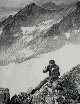 |
Setting mark near White Pass |
Southeast Alaska 1936 |
1616 |  |
Driving mark into the muskeg. Crew from PIONEER |
Amlia Island, Aleutian Islands, Alaska 1941 |
1617 |  |
Deep driven rods for bench marks. Crew from PATHFINDER |
Kodiak Island, Alaska 1969 |
1618 |  |
Digging a hole for a bench mark |
Southeast United States |
1619 |  |
Using gas drill to drill hole for bench mark |
Southeast Alaska |
1620 |  |
Mixing cement to set bench mark |
Southeast Alaska |
1621 |  |
Mark after being set in ground |
Southeast Alaska |
1622 |  |
Different types of bench marks |
|
1623 |  |
Original Station Winton North Base. Mark displaced by steam shovel. Triangulation party of E. O. Heaton |
Rochester, New York 1925 |
1624 |  |
Station Yolo SE Base. Triangulation party of Frank G. Johnson |
Sacramento Valley, California 1939 |
1625 |  |
Northwest Coast Indians deep-sixing bottle used as survey mark. Bottle set by party of George Davidson in 1852. Smallpox came after surveyors left. Indians felt bottle had evil spirits, dug up, and threw away |
Cape Flattery, Washington 1853 |
1626 |  |
Reference bottle at Station Principio |
|
1627 |  |
Triangulation station at Meade's Ranch. Control point for the North American Datum |
1940? |
1628 |  |
Historical monument explaining significance of Meade's Ranch. Control point for the North American Datum |
1955 |
1629 |  |
Old reference mark for Deming South Base. Triangulation party of Frank G. Johnson |
Deming, New Mexico 1939 |
1630 |  |
Hatcher Mountain Monument. Triangulation party of Frank G. Johnson |
New Mexico 1939 |
1631 |  |
Monument showing effects of wind erosion |
|
1632 |  |
Ferdinand Hassler's observing tent. Probably the original sketch was by John Farley |
New York area 1838? |
1633 |  |
View of summit station on Uncompaghre Peak - 14300 feet. 39th Parallel triangulation. Triangulation party of William Eimbeck |
Colorado 1895 |
1634 |  |
Observing station on Tushar Mountain - 12146 feet. 39th Parallel triangulation. Triangulation party of William Eimbeck |
Utah 1885 |
1635 |  |
Observing station on Round Top - 10386 feet. 39th Parallel triangulation. Astro and triangulation party of George Davidson |
California 1876 |
1636 |  |
Map of the 39th Parallel Arc. The first great geodetic arc in the western hemisphere |
United States 1871 - 1901 |
1637 |  |
Instrument station near Station 189. "Care needed in moving". International Boundary Survey |
141st Meridian - Alaska - Canada 1906 |
1638 |  |
Recorder attempting to find error in readings. International Boundary Survey |
Alaska - Canada Boundary |
1639 |  |
Triangulation station along 141st Meridian. Bandana for mosquitos. International Boundary Survey |
Alaska - Canada Boundary |
1640 |  |
White Pass West Base along the 141st Meridian. International Boundary Survey |
Alaska - Canada Boundary |
1641 |  |
Signal and small pole for observations on short lines. Triangulation party of J. B. Miller |
1910 |
1642 | 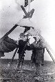 |
Mosquito protection. Survey work along Kuskokwim River. Survey crew off the YUKON |
1915 |
1643 |  |
Observing at triangulation station POW. Combined operations party of C. G. Quillian |
Pow Island, Hassler Harbor, Southeast Alaska 1915 |
1644 |  |
Primary triangulation work. Combined operations party of _ Daniels |
Clarence Strait, Southeast Alaska 1916 |
1645 |  |
C&GS 12" theodolite. Used in Clarence Straits work |
1916 |
1646 |  |
8" Wanschaff theodolite. Triangulation party of C. L. Garner |
Texas 1918 |
1647 |  |
Observing tent used to shelter instrument from the wind. Triangulation party of E. W. Eickelberg |
Oregon - California area 1920 |
1648 |  |
Station Caribou before being struck by lightning. William Scaife on left. Elevation 9816 feet. Triangulation party of William M. Scaife |
Idaho 1922 |
1649 |  |
Station Caribou after being struck by lightning - Elevation 9816 feet. Elevation 9816 feet. Triangulation party of William M. Scaife |
Idaho 1922 |

