| 250 |  |
Roy Sylar, truck driver and umbrella holder for the airplane beacon party of George L. Anderson. Roy served with the Coast and Geodetic Survey until into the 1960's. He was born the same day as Floyd Risvold, February 28, 1912. |
California, Southern 1932 |
251 |  |
Floyd Risvold, standing in front C&GS Truck no. 85., somewhere along the California coast. At this time he was the recorder for Lieutenant George L. Anderson's airport beacon party. |
California, Southern 1932 |
252 |  |
Not quite "The Grapes of Wrath." Floyd Risvold and Lieutenant George L. Anderson picking fruit during a break from duties with airport beacon location crew. |
California, Southern 1932 |
253 |  |
Airplane beacon, one of many located by the party of Lieutenant George L. Anderson, along the California coast. |
California, Southern 1932 |
254 |  |
Horse-packing into a station along the 46th Parallel. Lieutenant Ector B. Latham, Chief of Party. |
Montana 46th Parallel Survey, Cliff Creek, Lolo NF 1934 August 14 |
255 |  |
Horse-packing into a station along the 46th Parallel. Lieutenant Ector B. Latham, Chief of Party. Bill Husemeyer in photo. |
Montana, 46th Parallel Survey 1934 Summer |
256 |  |
The observing party at Station Bluff in Montana. |
Montana, Near White Sulphur Springs 1934 Summer |
257 |  |
The observing stand after taking down the shelter tent at Station Bluff. |
Montana, Near White Sulphur Springs 1934 Fall |
258 |  |
Dick Dana packing into Station Atacosa along the Arizona-Mexico border. |
Arizona-Mexico border 1935 March 12 |
259 |  |
Old Baldy, barely visible in the distance, as seen from Station Atacosa. Party of Lieutenant Ector B. Latham. |
Arizona-Mexico border 1935 March 12 |
260 |  |
Country on the Mexican border as seen from Station Atacosa. |
Arizona-Mexico border 1935 March 12 |
261 |  |
The lookout house at Station Atacosa. Roper Crawford packing theodolite No. 356 to station. Party of Lieutenant Ector B. Latham. |
Arizona-Mexico border 1935 March 12 |
262 |  |
Station Atacosa as seen from the trail. A one and a half hour pack. Party of Lieutenant Ector B. Latham. |
Arizona-Mexico Border area 1935 March 12 |
263 |  |
Station Sauharita. One of the few drive-to stations. Party of Lieutenant Ector B. Latham. |
Arizona-Mexico Border area 1935 March |
264 |  |
Floyd Risvold observing angles with theodolite No. 356 at Station Sauharita. |
Arizona-Mexico Border area 1935 March |
265 |  |
Snow in the desert near Nogales. |
Arizona, Near Nogales 1935 March? |
266 | 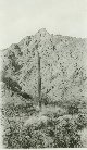 |
Station Hawk Peak as seen from the road. South of the Gila Valley. Lieutenant Jack Johnson, Chief of Party. |
Arizona, Between Gila Valley and Mexican Border 1934 |
267 |  |
A dangerous climb to Hawk Peak. Note observing stand at top of mountain. Lieutenant Jack Johnson, Chief of Party. |
Arizona, Hawk Peak 1934 |
268 |  |
Packing up Hawk Peak, 10627 feet, in the Pinaleno Mountains. Note packer in left center of picture and 4-foot observing stand at top of mountain. Lieutenant Jack Johnson, Chief of Party. |
Arizona, Hawk Peak 1934 |
269 |  |
Packing up Hawk Peak, 10627 feet, in the Pinaleno Mountains. A picture designed for vertigo. |
Arizona, Hawk Peak 1934 |
270 |  |
Packers lending each other helping hands as making way to the top of 10,627 foot Hawk Peak in the Pinaleno Mountains. Lieutenant Jack Johnson, Chief of Party. |
Arizona, Hawk Peak 1934 |
271 |  |
Observing tent on triangulation station on the top of Hawk Peak, 10,627 feet, in the Pinaleno Mountains. Lieutenant Jack Johnson, Chief of Party. |
Arizona, Hawk Peak 1934 |
272 |  |
A photo opportunity along Cliff Creek in the Lolo National Forest area along the Idaho-Montana border. In today's Selway-Bitterroot Wilderness Area. |
Montana 46th Parallel Survey, Cliff Creek, Lolo NF 1934 August 14 |
273 |  |
Late summer/ early fall snow in area along the Montana-Idaho border area. Lieutenant Ector B. Latham, Chief of Party, on the right. |
Montana-Idaho border area 1934 September |
274 |  |
Somewhere in the West. Floyd Risvold observing, Dube Erickson recording. Somewhere in the West. |
Arizona ? 1933? |
275 |  |
Station Glendive was the center of the water tank at Glendive. Note the observing tent set up over the center of the tower. |
Montan, Glendive |
276 |  |
"Three Wise Men". Leonard C. "Jack" Johnson on left (outgoing party chief), Ector Latham in center (new party chief), Jack Bachtel. This was when the party was moving north up the 115th meridian and was working in SW Colorado. |
Colorado, Southwest June 1934 June |
277 |  |
Clarence Olson, Bill Husemeyer, and Floyd Risvold breaking camp at Graingerville, Idaho. |
Idaho, Grainger 1934 August |
278 |  |
Most of the crew together at a Sunday afternoon in camp. |
Colorado, Southwest 1934 June |
279 |  |
Standing: Bill Bussey, L.C. "Jack" Johnson, Cartwright, W. C. Names, Charles Hoepell. Kneeling: Floyd Risvold, Truman "Shorty" Pearson, Jack Bachtel. |
Montana, White Sulphur Springs 1934 July |
280 |  |
On the way to Station Lone Cone in Southwest Colorado. A two hour ride followed by a 1 hour and 50 minute pack from timberline to the top of the mountain. |
Colorado, Near Norwood 1934 July |
281 |  |
On the way to Station Lone Cone in Southwest Colorado. A two hour ride followed by a 1 hour and 50 minute pack from timberline to the top of the mountain. |
Colorado, Near Norwood 1934 July |
282 |  |
On the way to Station Lone Cone in Southwest Colorado. A two hour ride followed by a 1 hour and 50 minute pack from timberline to the top of the mountain. |
Colorado, Near Norwood 1934 July |
283 |  |
On the way to Station Lone Cone in Southwest Colorado. A two hour ride followed by a 1 hour and 50 minute pack from timberline to the top of the mountain. |
Colorado, Near Norwood 1934 July |
284 |  |
On the way to Station Lone Cone in Southwest Colorado. A two hour ride followed by a 1 hour and 50 minute pack from timberline to the top of the mountain. |
Colorado, Near Norwood 1934 July |
285 |  |
On the way to Station Lone Cone in Southwest Colorado. A two hour ride followed by a 1 hour and 50 minute pack from timberline to the top of the mountain. |
Colorado, Near Norwood 1934 July |
286 |  |
On the way to Station Lone Cone in Southwest Colorado. A two hour ride followed by a 1 hour and 50 minute pack from timberline to the top of the mountain. |
Colorado, Near Norwood 1934 July |
287 |  |
On the way to station Kofa (acronym for King of Arizona Mine). |
Arizona, Kofa Mountains 1934 November |
288 |  |
Heading into a canyon on the way to Station Kofa. This was a very dangerous station requiring climbing with ropes to get to. |
Arizona, Kofa Mountains 1934 November |
289 |  |
Heading up a canyon on the way to Station Kofa. This was a very dangerous station requiring climbing with ropes to get to. |
Arizona, Kofa Mountains 1934 November |
290 |  |
Heading up a canyon on the way to Station Kofa. This was a very dangerous station requiring climbing with ropes to get to. |
Arizona, Kofa Mountains 1934 November |
291 |  |
Heading up a canyon on the way to Station Kofa. This was a very dangerous station requiring climbing with ropes to get to. |
Arizona, Kofa Mountains 1934 November |
292 |  |
Observing party on Station Kent near Las Cruces, New Mexico. |
Arizona, Mount Graham, Pinaleno Mountains 1934 November |
293 |  |
Packing mules with lumber to build tower on Mt. Graham in the Pinaleno Mountains near Safford, Arizona. Mt. Graham now is the site of the Mt. Graham Astronomical Observatory. |
Arizona, Mt. Graham, Coronado National Forest 1934 March 30 |
294 |  |
Packing mules with lumber to build tower on Mt. Graham in the Pinaleno Mountains near Safford, Arizona. Mt. Graham now is the site of the Mt. Graham Astronomical Observatory. |
Arizona, Mount Graham, Pinaleno Mountains 1934 March 30 |
295 |  |
Packing mules with lumber to build tower on Mt. Graham in the Pinaleno Mountains near Safford, Arizona. Mt. Graham now is the site of the Mt. Graham Astronomical Observatory. |
Arizona, Mount Graham, Pinaleno Mountains 1934 March 30 |
296 |  |
Packing mules with lumber to build tower on Mt. Graham in the Pinaleno Mountains near Safford, Arizona. Mt. Graham now is the site of the Mt. Graham Astronomical Observatory. |
Arizona, Mount Graham, Pinaleno Mountains 1934 March 30 |
297 |  |
Packing mules with lumber to build tower on Mt. Graham in the Pinaleno Mountains near Safford, Arizona. Mt. Graham now is the site of the Mt. Graham Astronomical Observatory. |
Arizona, Mount Graham, Pinaleno Mountains 1934 March 30 |
298 | 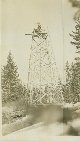 |
Forty foot tower built on Mount Graham in the Pinaleno Mountains. Tower was required to see over surrounding timber. |
Arizona, Mount Graham, Pinaleno Mountains 1934 March 30 |
299 |  |
Forty foot tower built on Mount Graham in the Pinaleno Mountains. Tower was required to see over surrounding timber. |
Arizona, Mount Graham, Pinaleno Mountains 1934 March 30 |

