| 2650 |  |
Roberts Radio Current Meter ready for deployment in Akutan Pass. |
Akutan Pass, Aleutian Islands, Alaska 1950 |
2651 |  |
Streamlined buoy with Roberts Radio Current Meter. Ready for deployment in Akutan Pass |
Akutan Pass, Aleutian Islands, Alaska 1950 |
2652 | 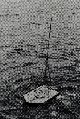 |
Streamlined buoy with Roberts Radio Current Meter. Deployed in Unalga Pass |
Unalga Pass, Aleutian Islands, Alaska 1950 |
2653 | 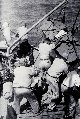 |
Full-crew effort to recover current meter buoy. Even the cook was involved. Off of WAINRIGHT. Photo #2 of sequence |
Chesapeake Bay 1952 |
2654 | 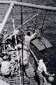 |
Full-crew effort to launch current meter buoy. Off of WAINRIGHT. Photo #1 of sequence |
Chesapeake Bay 1952 |
2655 |  |
Recovery of current buoy from approach to nearly on deck. Off of WAINRIGHT. Photo #3 of sequence |
Chesapeake Bay 1952 |
2656 |  |
Current meter buoy being deployed from the EXPLORER |
Delarof Islands, Aleutian Islands, Alaska 1952 |
2657 |  |
Current meter buoy being lowered to the rail. Off of PATHFINDER |
Kasaan Bay, Prince of Wales Island, Alaska 1958 |
2658 |  |
Installing current meter at Cape Seniavin. Off of PATHFINDER |
Cape Seniavin, Bristol Bay, Alaska 1960 |
2659 |  |
Current meter at Cape Seniavin installed by PATHFINDER. |
Cape Seniavin, Bristol Bay, Alaska 1960 |
2660 |  |
Emerson E. Jones checking the wire angle with a 3-arm protractor. Over-the-side operations on the MARMER |
Charleston, South Carolina 1962 |
2661 |  |
Buoy in tow from the MARMER. Towing buoy to station location |
Charleston, South Carolina 1962 |
2662 |  |
Current buoy in strong currents in Charleston Harbor. Station established by the MARMER |
Charleston, South Carolina 1962 |
2663 |  |
C. William Hayes' first command. Just kidding - checking batteries and electronics package |
Charleston, South Carolina 1962 |
2664 | 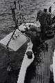 |
Deploying a current meter from the MARMER. Working off the MARMER |
Tampa Bay, Florida 1963 |
2665 |  |
Gabby - the talking current buoy. Gabby getting a new face for a Norfolk, Virginia, open house. MARMER hosted open house for general public. Article appeared in Norfolk Ledger-Star on November 13, 1963 |
Charleston, South Carolina 1963 |
2666 |  |
Current buoys on deck on the FERREL for Maine project. |
Penobscot Bay, Maine 1970? |
2667 |  |
Current buoy and meter being deployed in Penobscot Bay. Deployment off of FERREL |
Penobscot Bay, Maine 1970? |
2668 |  |
Current buoy in water in Penobscot Bay. Deployment off of FERREL |
Penobscot Bay, Maine 1970? |
2669 |  |
NOAA Launch 1255 with crane for handling current buoys and meters. Launch 1255 worked with FERREL in Penobscot Bay |
Penobscot Bay, Maine 1970? |
2670 |  |
Current meter with trash catcher to keep impeller from being fouled. Deployed off of FERREL |
|
2671 |  |
Bottom mounted current meter being deployed from FERREL. Project to determine path of brine plume from salt dome solution and pumping. Studies during formation of Strategic Petroleum Reserve |
Gulf of Mexico 1978? |
2672 |  |
Colonel E. Lester Jones and Honorable J. D. Craig. On EXPLORER on International Boundary Commission inspection tour. Colonel Jones was a founder of the American Legion |
Southeast Alaska 1927 |
2673 |  |
Picking up pilot and radio operator from recon airplane off Oahu. Plane ran out of fuel and landed on water searching for Japanese fleet. Picked up by EXPLORER 3 days after Pearl Harbor |
Hawaii December 10, 1941 |
2674 |  |
Route of 17th Field Artillery Observation Battalion through Belgium and Germany. 17th FAOB was on the north shoulder of the Bulge. Photo from 17th FAOB Album |
Europe 1945 |
2675 |  |
Route of 17th Field Artillery Observation Battalion through England and France. 17th FAOB landed one day after D-Day. Engaged at Falaise Gap in France, marched through Paris |
Europe 1944 |
2676 |  |
Training maneuvers on the Dartmoors prior to D-Day. Personnel of the 17th FAOB. Photo from 17th FAOB Album |
England 1944 |
2677 |  |
Meteorological observations on the Dartmoors. 17th FAOB training exercises prior to D-Day. Photo from 17th FAOB Album |
England 1944 |
2678 |  |
Transit party training on the Dartmoors. 17th FAOB training exercises prior to D-Day. Photo from 17th FAOB Album |
England 1944 |
2679 |  |
Lieutenant Fountain and Sergeant Newton on reconnaissance training. 17th FAOB training exercises prior to D-Day. Photo from 17th FAOB Album |
England 1944 |
2680 |  |
Survey party entering Vire, France, shortly after D-Day. 17th FAOB. Photo from 17th FAOB Album |
France 1944 |
2681 |  |
Flash ranging command post overlooking the Rhine River. 17th FAOB. Photo from 17th FAOB Album |
Belgium 1944 |
2682 |  |
Flash ranging command post overlooking the Rhine River. 17th FAOB. Photo from 17th FAOB Album |
Belgium 1944 |
2683 |  |
Survey work at Kesternich. 17th FAOB. Photo from 17th FAOB Album |
Germany 1945 |
2684 |  |
Members of 17th FAOB at Ehrenbreitstein Fortress. L to R - Deily, Bacon, Richey, Harding, Riback, Snyder, Stewart. Photo from 17th FAOB Album |
Germany 1945 |
2685 |  |
Frontispiece from the History of the 17th Field Artillery Observation Battalion. Image from 17th FAOB Album |
|
2686 |  |
All in a days work for the members of the 17th FAOB. Shooting, running line, stopping for chow, rodman, and observer with transit. Image from 17th FAOB Album |
|
2687 |  |
Running the transit - survey work with the 17th FAOB. Image from 17th FAOB Album |
|
2688 |  |
Route of the 8th FAOB. Image from the 8th FAOB Album |
Europe 1944-45 |
2689 |  |
Diagram of sound ranging coverage with artillery firing possibilities. Image from the 8th FAOB Album |
Germany April 17, 1945 |
2690 |  |
Sound ranging operations of 8th FAOB. 70 sound bases established in less than one year. Image from the 8th FAOB Album |
Europe 1944-45 |
2691 |  |
Flash observer at work. 25 flash bases established. Image from the 8th FAOB Album. |
Europe 1944-45 |
2692 |  |
Over 4,000 miles of wire laid to communicate with sound and flash ranging bases. Image from the 8th FAOB Album |
Europe 1944-45 |
2693 |  |
Flash ranging operations. Image from the 8th FAOB Album |
Europe 1944-45 |
2694 |  |
Composite of all operations associated with 8th FAOB. Image from the 8th FAOB Album |
Europe 1944-45 |
2695 |  |
The bottom line - determined 7,016 enemy targets for Allied artillery. Image from the 8th FAOB Album |
Europe 1944-45 |
2696 |  |
Captured German map showing geodetic control around St. Nazaire, France. |
France 1944-45 |
2697 |  |
Title page of captured German geodetic control book for St. Nazaire. |
France 1944-45 |
2698 |  |
Listing of geodetic control points with rectangular coordinates. From captured German geodetic control book for St. Nazaire |
France 1944-45 |
2699 |  |
Listing of geodetic control points with rectangular coordinates. From captured German geodetic control book for St. Nazaire |
France 1944-45 |

