| 800 |  |
PATHFINDER at the dock at Dutch Harbor. |
Alaska, Aleutian Islands, Dutch Harbor |
801 |  |
Unit sign for the Navy Aero Unit at Dutch Harbor. Aero is short for Aerographer 's facility or the Weather Office as it would be known in the civilian world. |
Alaska, Aleutian Islands, Dutch Harbor |
802 |  |
Building materials being taken to shore for shore camps at St. Paul. |
Alaska, Pribilof Islands, St. Paul |
803 |  |
Launch pickup on the PATHFINDER. |
Alaska, Bering Sea |
804 |  |
PATHFINDER at the dock at Dutch Harbor. |
Alaska, Aleutian Islands, Dutch Harbor |
805 |  |
LCVP used by PATHFINDER for landing men, equipment, and building supplies. |
Alaska, Bering Sea |
806 |  |
Jack Scherting at the throttles of the PATHFINDER. |
Alaska, Bering Sea |
807 |  |
"Notice to all firemen and oilers - Keep hands off the Bailey Board" by Casey. |
Alaska, Bering Sea |
808 |  |
A stormy day on the Bering Sea. |
Alaska, Bering Sea |
809 |  |
A stormy day on the Bering Sea. |
Alaska, Bering Sea |
810 |  |
PATHFINDER at anchor in Laska Cove. |
Alaska, Aleutians, Kagalaska Island |
811 |  |
The PATHFINDER at St. Paul, Pribilof Islands. |
Alaska, Pribilof Islands, St. Paul |
812 |  |
Thick-billed murre rookery. |
Alaska, Pribilof Islands, St. Paul |
813 |  |
Laska Cove scenery. |
Alaska, Aleutians, Kagalaska Island |
814 |  |
Anchor chain on launch off PATHFINDER. |
Alaska, Bering Sea |
815 |  |
Coast Guard Cutter TANEY in Dutch Harbor after search and rescue operation. |
Alaska, Aleutian Islands, Dutch Harbor |
816 |  |
Coast Guard Cutter TANEY. |
Alaska, Aleutian Islands, Dutch Harbor |
817 |  |
Early morning at Adak piers. |
Alaska, Aleutian Islands, Adak |
818 |  |
Low clouds and mountains while coming into Adak Harbor. |
Alaska, Aleutian Islands, Adak |
819 |  |
Approaching the Adak piers. |
Alaska, Aleutian Islands, Adak |
820 |  |
An iron-bound coast approaching Adak. |
Alaska, Aleutian Islands |
821 |  |
Approaching Adak. |
Alaska, Aleutian Islands |
822 |  |
Volcanic islands approaching Adak. |
Alaska, Aleutian Islands |
823 |  |
Sunset in the Pribilof Islands. |
Pribilof Islands |
824 |  |
A spring dawn while approaching Adak. |
Alaska, Aleutian Islands |
825 |  |
Ragged Point. |
Alaska, Aleutian Islands, Kagalaska Island |
826 |  |
The high peak was a triangulation station that had to be climbed to from the shore. |
Alaska, Aleutian Islands, Kagalaska Island |
827 |  |
Triangulation Station Raggy at Ragged Point. |
Alaska, Aleutian Islands, Kagalaska Island |
828 |  |
Andrew Jackson monument as engraved by Albert Boschke. |
Washington, D.C. 1856 ca. |
829 |  |
U.S. Patent Office as engraved by Albert Boschke. |
Washington, D.C. 1856 ca. |
830 |  |
Doing range-azimuth hydrography off Canadian Hydrographic Service Ship MAXWELL. |
Canada, New Brunswick, Passamaquoddy Bay 1985 Summer |
831 |  |
Doing range-azimuth hydrography off NOAA Ship PEIRCE. PEIRCE is to right of observer. Motorola Mini-Ranger (white box) is distance measuring instrument on tripod. |
Wisconsin, Apostle Islands, Lake Superior 1982 |
832 |  |
Bosun Group Leader Al Washington and Seaman Mike Briscoe erecting tower for supporting Motorola Mini-Ranger. Person in blue unidentified. |
U.S. Virgin Island, St. Croix north shore 1981 |
833 |  |
ARGO electronic navigation system transmitting antenna being erected. Gin pole is used as lever on left of image. |
Wisconsin, Apostle Islands, Lake Superior 1982 |
834 |  |
Range Azimuth setup with Wild T-2 Theodolite used for observing azimuth to Canadian Hydrographic Service launch off CHS MAXWELL. |
Canada, New Brunswick, Campobello Island 1985 |
835 |  |
NOAA Ship PEIRCE crew erecting hydrographic signal over survey mark. |
Wisconsin, Apostle Islands, Lake Superior 1982 |
836 |  |
Hydrographic signal erected by crew off NOAA Ship PEIRCE. |
Wisconsin, Apostle Islands, Lake Superior 1982 |
837 |  |
Large hydrographic signal erected by crew off NOAA Ship PEIRCE. This signal and other similar signals were used by ship to calibrate electronic navigation systems. |
Wisconsin, Apostle Islands, Lake Superior 1982 |
838 |  |
Orange banner hung off cliff to serve as hydrographic signal by crew off NOAA Ship PEIRCE. |
Wisconsin, Apostle Islands, Lake Superior 1982 |
839 |  |
Lieutenant George Leigh setting up a target and light for geodetic survey observations. |
Wisconsin, Apostle Islands, Lake Superior 1982 |
840 |  |
Lieutenant George Leigh setting up a target and light for geodetic survey observations. |
Wisconsin, Apostle Islands, Lake Superior 1982 |
841 |  |
Motorola Mini-Ranger super high-frequency navigation transceiver mounted on 20-foot aluminum mast to increase useable distance of this line-of-sight navigation system. |
Wisconsin, Apostle Islands, Lake Superior 1982 |
842 | 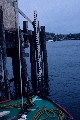 |
Canadian Hydrographic Service tide staff graduated in meters. |
Canada, New Brunswick, Passamaquoddy Bay 1982 |
843 |  |
Bubbler tide gauge mounted on tree with tubing going to underwater orifice. The two tide staffs were necessary to cover the full range of tide of approximately 25 feet. |
Canada, New Brunswick, Passamaquoddy Bay 1982 |
844 |  |
Ensign Marty Conricote checking an ADR water-level gauge on Lake Superior. The gauge to the left was operated by the U.S. Army Corps of Engineers. These gauges were in a Lake Superior harbor. |
Wisconsin 1983 |
845 |  |
Tide staff in southeast Alaska. |
Alaska, Elfin Cove 1991 |
846 |  |
U.S. tide staff graduated in feet being installed by NOS/COOPS personnel. |
Maine, Cobscook Bay 1985 |
847 |  |
Description not available. |
|
848 |  |
Description not available. |
|
849 |  |
Description not available. |
|

