| 550 |  |
U.S. Department of Commerce/ Coast and Geodetic Survey aeronautical chart display. ION/RTCA/RTCM meeting at Astor Hotel. |
1950 September 20 |
551 |  |
U.S. Department of Commerce/ Coast and Geodetic Survey hydrographic survey display. ION/RTCA/RTCM meeting at Astor Hotel. |
1950 September 20 |
552 |  |
U.S. Department of Commerce/ Coast and Geodetic Survey public affairs display at the Miami International Boat Show. |
Florida, Miami 1965 March |
553 |  |
U.S. Department of Commerce/ Coast and Geodetic Survey hydrographic survey display. At U.S. Power Squadron Meeting at Astor Hotel. J.J. Rafferty, a C&GS employee stationed at New York is second from left. |
1952 January |
554 |  |
Meades Ranch, Kansas, the datum point for the North American Datum of 1927. |
Kansas, Meades Ranch 1940 ca. |
555 |  |
Earthquake belts of the Earth, a map produced by Commander Nicholas Heck, C&GS, about 1935. Note earthquake occurrences on Mid-Atlantic Ridge and following Pacific Ring of Fire. |
|
556 |  |
Aerial photograph taken with single lens camera. |
1930 ca. |
557 |  |
North Slope tractor train during Dew Line geodetic surveys. |
Alaska, North Slope 1950 ca. |
558 |  |
Level crew at the White House. A C&GS crew checked the walls of the White House ever four years for subsidence or ground uplift. |
|
559 |  |
Lieutenant Eugene Taylor operating Bamberg astronomic transit. |
1960 ca. |
560 |  |
Measuring baseline with Invar Tape, maintaining constant tension during reading. Making rear contact on bench over traverse station. |
1938 July |
561 |  |
Leveling operations in vicinity of Bilby tower. |
1950 ca. |
562 |  |
A buoy used for offshore surveying. |
1930 ca. |
563 | 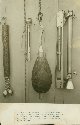 |
Bottom sampling device, detachable weight used during piano-wire sounding operations, and water sampling cup. All these instruments were used in deep-sea sounding operations. |
1915 ca. |
564 |  |
The radio room of a Coast and Geodetic Survey ship. |
1950 November |
565 |  |
Lieutenant Hubert Keith reading temperatures measured by deep-sea reversing thermometers. |
1960 ca. |
566 |  |
Collecting bottom sample material to determine anchoring characteristics of bottom. These samples were sent to the Smithsonian Institution after describing for charting purposes. |
1950 ca. |
567 |  |
Chief Survey Technician hanging a Nanson bottle for collecting water specimen and measuring temperature at depth. |
1960 ca. |
568 |  |
Saugerties Lighthouse, Hudson River. |
1920 ca. |
569 | 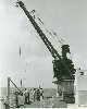 |
5 ton crane being used for over-the-side oceanographic operations. |
|
570 |  |
Dredge and trawl winch. |
|
571 |  |
Commander Marvin Paulson hanging a Nanson bottle for collecting water specimen and measuring temperature at depth. |
|
572 |  |
The radio room of a Coast and Geodetic Survey ship. |
|
573 |  |
Landing supplies for Shoran Station. |
Alaska, Little Sitkin Island, Aleutians 1948 ca. |
574 | 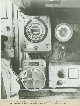 |
Chief Radio Technician, Ricardo Vendura, operating a depth recorder and monitoring a gyro repeater in the radio room of the U. S. Coast Survey Ship Tulip. This was just prior to the Philippine Islands gaining their independence . |
Philippine Islands 1949 ca. |
575 |  |
Lieutenant Commander Franklin R. Gossett and Chief Petty Officer Savage operating sounding equipment aboard the USC&GS Ship OCEANOGRAPHER. |
1938 ca. |
576 |  |
The Atlantic Marine Center, the USC&GS ship base. |
1962 ca. |
577 |  |
Smiling Coast Surveyors in the Director's Office of the C&GS Atlantic Marine Center. |
1965 ca. |
578 |  |
Smiling Coast Surveyors in the Washington, D.C. Headquarters of the C&GS. |
|
579 |  |
Atlantic Marine Center, ESSA C&GS ship base. |
1968 ca. |
580 |  |
Atlantic Marine Center, C&GS ship base. |
1961 March |
581 |  |
Atlantic Marine Center, C&GS ship base. Empty field in center of picture became C&GS thence NOAA storage yard. |
1968 February 13 |
582 |  |
Atlantic Marine Center, ESSA C&GS ship base. |
1965 ca. |
583 |  |
Atlantic Marine Center, ESSA C&GS ship base. |
1965 ca. |
584 |  |
Compensating a magnetic compass. USC&GS Ship BACHE. |
1915 ca. |
585 | 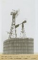 |
Shoran installation on radar tower on Agattu Island. This was part of the first electronic navigation project carried out by the C&GS following their adaptation of the aerial bombing navigation system "GEE" to Shoran. Captain Clarence Burmister of the C&GS was instrumental in developing Shoran as a hydrographic survey navigation system. |
Alaska, Agattu Island, Aleutians 1945 |
586 |  |
ESSA C&GS Atlantic Marine Center ship base. |
Virginia, Norfolk 1969 |
587 |  |
C&GS Atlantic Marine Center ship base. |
Virginia, Norfolk 1961 |
588 |  |
Unidentified oceanographic operations. |
1964? |
589 |  |
Chief Survey Technician securing Nansen bottle for temperature- water characteristic studies on line. Lieutenant Hubert Keith looks on. |
Atlantic Ocean 1965 ca. |
590 |  |
Recorder noting depths as showing on 808 Fathometer display. |
1950 ca. |
591 |  |
Unidentified oceanographic operations. |
Atlantic Ocean 1964? |
592 |  |
Recorder noting depths as showing on 808 Fathometer display. |
1956 November |
593 |  |
Portable depth recorder used with 808 Fathometer system. |
1950 ca. |
594 |  |
Hand lowering current measuring instrument. |
1950 ca. |
595 |  |
Current survey party at work. |
1935 ca. |
596 |  |
Lieutenant Dale North checking distances on first automated hydrographic system on NOAA high speed launch 1257. |
Atlantic Ocean 1971 October |
597 |  |
Taking simultaneous readings with Worden gravimeter. |
|
598 |  |
The Cheltenham Magnetic Observatory. |
Maryland, Cheltenham |
599 |  |
A Milne-Shaw Seismograph. |
|

