| 2700 | 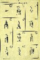 |
Diagrams of objects used to establish azimuth for orienting artillery. From captured German geodetic control book for St. Nazaire |
France 1944-45 |
2701 |  |
Sketches with maps of various geodetic control points. From captured German geodetic control book for St. Nazaire |
France 1944-45 |
2702 |  |
Group photograph of ill-fated Battery B of the 285th FAOB. Major Fair J. Bryant was executive officer and survey officer of the 285th FAOB. |
Fort Sill, Oklahoma 1944 |
2703 |  |
"Malmedy Massacre" - approximately 70 members of Battery B killed after captured . Fair J. Bryant was travelling with Battery A of 285th at time of massacre. Occurred at beginning of Battle of the Bulge |
Malmedy, Belgium December 17, 1944 |
2704 |  |
Commander Maurice A. Hecht at left - first instructor for radar ranging class. Observation battalion training in use of radar to determine enemy gun location |
Fort Sill, Oklahoma 1944 |
2705 |  |
Officers' Sound and Flash Ranging Class No. 16. #9- Harry D. Reed; #11 - Charley Schanck; #12 C. M. Shinn |
Fort Sill, Oklahoma 1944 |
2706 |  |
Typical Corps Survey Problem. Illustrating the complexity of battlefield surveying |
Fort Sill, Oklahoma Post WW II |
2707 |  |
Francis X. Popper plotting hydrographic survey in New Guinea. Regimental navigator for Army amphibious engineers. May and Larusso standing guard |
New Guinea 1944 |
2708 |  |
Chart of Efate Island produced on board the PATHFINDER. Printed on board in July 1943. Green areas denote wiredrag coverage |
Efate Island, New Hebrides, Pacific Ocean 1943 |
2709 |  |
Chart of Lifa-Uvea Passage produced on board the PATHFINDER. Printed on board in September 1944 |
Lifa-Uvea Passage, Loyalty Islands, Pacific Ocean |
2710 |  |
Massacre Bay. HYDROGRAPHER led transports and combatants to anchorage areas during invasion |
Attu, Aleutian Islands, Alaska 1946 |
2711 |  |
Marine mapping party working with a plane table. Photo from article in Military Engineer |
Solomon Islands 1943? |
2712 |  |
Marine photographic intelligence work. Photo from article in Military Engineer |
Southwest Pacific 1943? |
2713 |  |
Relief map of Truk Island developed to guide bombing missions. Work of Roswell Bolstad while Marine intelligence officer |
Truk Islands 1944 |
2714 |  |
Approach recognition chart of Truk Islands. Chart shows varying aspects of Truk while approaching from different directions . Work of Roswell Bolstad while Marine intelligence officer |
Truk Islands 1944 |
2715 |  |
Anti-aircraft battery at Guadalcanal commanded by Robert A. Earle. Early use of C&GS by Marines |
Guadalcanal 1943 |
2716 |  |
Artillery survey crew of 10th Marines with 3 captured Japanese battle flags. Survey crew caught in middle of huge Japanese banzai charge at Battle of Saipan . Robert A. Earle, in center front, commanding officer of survey crew |
Saipan, Marianas Islands July 13, 1944 |
2717 |  |
Artillery survey crew of 10th Marines with survey gear. Commanded by Robert A. Earle, back row 4th from left |
Saipan, Marianas Islands July 13, 1944 |
2718 |  |
Amphibious landing beach on Tinian at H+5 hours. Note survey crew on left already beginning work for artillery survey |
Tinian, Marianas Islands |
2719 |  |
Measuring a baseline at low tide across reef area. |
Western Pacific 1944? |
2720 |  |
Jeremiah Morton's survey crew on Saipan. Newspaper article termed Morton and his crew "sniper bait" |
Saipan, Marianas Islands July 1944 |
2721 |  |
Hydrographic survey signal on Mt. Suribachi, Iwo Jima. This signal was erected within a short time of the famous American flag raising . |
Mt. Suribachi, Iwo Jima February 1945 |
2722 |  |
Transportation on the upper Amazon River. Transporting survey crews of Carl Aslakson. Aslakson with Army Air 311th Air Photo Wing |
Upper Amazon River, Brazil 1943 |
2723 |  |
Projection scheme for aeronautical charts of the U.S. Army Air Forces. This scheme was developed by Paul A. Smith, head of C&GS aeronautical charting. Army Air Forces routes pioneered modern commercial routes |
1943 |
2724 |  |
C&GS Puerto Princesa, Philippines chart with military grid. Philippine Islands covered by C&GS charts prior to war. Charts helped U.S. forces transport men and equipment. Offensive operations planned using C&GS charts as well |
Puerto Princesa, Philippines 1944 |
2725 |  |
Photo of Nazi submariner foot (?) trying to get out of submarine escape hatch. Office of Strategic Services project to find sunken vessels with new technology . Ray Tryon and John O. Phillips worked off USCGC GENTIAN in 1944. Example of early surface controlled ocean bottom photography |
New York Bight area 1944 |
2726 |  |
Woman professional operating tide prediction machine. World War II opened up many opportunities for women. Over 1/2 of males with C&GS joined the Armed Services |
Washington, D.C. 1944 |
2727 |  |
WEMS - The Women's Emergency Map Service. WEMS started as a joke passed to press that ran national article. Although never a formal service, women functioned in many C&GS jobs during war. By war's end, there was more truth to WEMS than cartoonist had visualized |
Washington, D.C. February 1943 |
2728 |  |
Women operating automatic projection ruling machine |
Washington, D.C. 1944 |
2729 |  |
Woman operating photo-reproduction equipment |
Washington, D.C. 1944 |
2730 |  |
Woman draftsman preparing chart manuscript |
Washington, D.C. 1944 |
2731 |  |
Women working in map-folding room |
Washington, D.C. 1944 |
2732 |  |
Officer discussing work with woman operating photogrammetric stereoplotter. |
Washington, D.C. 1944 |
2733 |  |
Wrecked Japanese ship at Kiska |
Kiska, Aleutian Islands, Alaska 1946 |
2734 |  |
Another wrecked Japanese ship at Kiska |
Kiska, Aleutian Islands, Alaska 1946 |
2735 |  |
Scrambling through the scree |
Alaska Peninsula 1944 |
2736 |  |
Bob Pryce taking a breather at the station |
Alaska Peninsula 1944 |
2737 |  |
Bob Pryce getting near the top. On the way to Station Wide |
Alaska Peninsula 1944 |
2738 |  |
Climbing through the snow on the ridge lines. On the way to Station Wide |
Alaska Peninsula 1944 |
2739 |  |
Coming down the mountain. |
Aleutian Islands, Alaska |
2740 |  |
One slip and you'll have some cold feet. On the way to Station Wide |
Alaska Peninsula 1944 |
2741 |  |
Resting up and taking in the view. On the way to Station Wide |
Alaska Peninsula 1944 |
2742 |  |
Packing into Yellowstone. Yellowstone National Park area 1950. One of the last horseback operations in the C&GS |
Yellowstone area, Wyoming 1950 |
2743 |  |
Getting out before the snow gets deep. Yellowstone National Park area 1950. One of the last horseback operations in the C&GS |
Black Mountain, Montana 1950 |
2744 |  |
Getting out before the snow gets deep - Bob Pryce with a little snow. Yellowstone National Park area 1950. One of the last horseback operations in the C&GS |
Yellowstone area, Wyoming 1950 |
2745 |  |
Getting out before the snow gets deep. Yellowstone National Park area 1950. One of the last horseback operations in the C&GS |
Black Mountain, Montana 1950 |
2746 |  |
Horseback packing out of remote areas of Yellowstone - 1950. The snow is beginning to fly. One of the last horseback operations in the C&GS |
Lake High, Montana 1950 |
2747 |  |
Crossing the Firehole River in Yellowstone National Park. One of the last horseback operations in the C&GS |
Firehole River, Yellowstone National Park, Wyoming 1950 |
2748 | 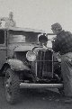 |
Sometimes old Betsy needs a drink of water |
|
2749 |  |
Truck transportation in western United States - ca. 1940's |
|

