| 700 |  |
Haskell water level gauge in water level house. |
Indiana, Fort Wayne 1937 September |
701 |  |
Haskell water level gauge showing workings. |
|
702 |  |
Lake Survey employee Jim Morris annotating water level gauge. |
Indiana, Fort Wayne 1937 September |
703 |  |
Fisher and Porter Automatic Digitally Recording water level gauge. |
Great Lakes 1971 ca. |
704 |  |
Water level gauge with Stevens Recorder. |
Great Lakes 1960 ca. |
705 |  |
Interior of water level gauge station house. |
Great Lakes 1971 ca. |
706 |  |
Fisher and Porter Automatic Digitally Recording water level gauge. |
Great Lakes 1971 ca. |
707 |  |
Lake Survey employee Jim Morris annotating water level gauge. |
Indiana, Fort Wayne 1937 September |
708 |  |
Lake Survey employee Jim Morris annotating water level gauge. |
Great Lakes 1937 September |
709 |  |
Lake Survey employee Jim Morris annotating water level gauge. |
Great Lakes 1937 September |
710 |  |
Haskell water level gauge. |
Great Lakes 1937ca. |
711 |  |
Haskell water level gauge. |
Great Lakes 1937ca. |
712 |  |
Fisher and Porter Automatic Digitally Recording water level gauge. |
Great Lakes 1971 ca. |
713 |  |
Map showing Great Lakes Basin precipitation stations. |
Great Lakes. 1953 |
714 |  |
Menu for tenth anniversary celebration of the directorship of E. Lester Jones. |
Washington, D.C. 1925 April 15 |
715 |  |
Cover for menu and program of tenth anniversary celebration of E. Lester Jones serving as Director of the Coast and Geodetic Survey. |
Washington, D.C. 1925 April 15 |
716 | 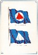 |
Coast and Geodetic Survey flag and Director's flag on April 15, 1925 banquet menu and program celebrating 10th year of E. Lester Jones as Director of the C&GS. |
Washington, D.C. 1925 April 15 |
717 |  |
Source document for maps showing various magnetic elements obtained by W.H. Emory on the Mexican Boundary Survey and the Coast Survey on the West Coast. See image cgs00734. |
1855 |
718 |  |
Iso-magnetic lines showing change in declination for Pennsylvania between 1842 and 1862 and other magnetic parameters as compiled by A.D. Bache. |
Pennsylvania 1863 |
719 |  |
"Abstract of results of a Magnetic Survey of Pennsylvania...." by Alexander Dallas Bache, 1863. |
Pennsylvania 1863 |
720 |  |
Magnetic dip and variation compiled by W. H. Emory of the Mexican Boundary Survey and Alexander Dallas Bache of the U.S. Coast Survey. |
United States, Western States 1855 |
721 |  |
Observing at triangulation station on Hughes High School. |
Ohio, Cincinnati 1912 |
722 |  |
Double-tower triangulation signal at station Observatory of the Cincinnati Survey. |
Ohio, Cincinnati 1912 |
723 |  |
Engraving of the White House by Albert Boschke of the Coast Survey. |
Washington, D.C. 1856 ca. |
724 |  |
Engraving of George Washington's National Monument by Albert Boschke of the Coast Survey. This apparently was the envisioned version of the Washington Monument as the monument was not dedicated until 1885 and the base area has never looked like the view produced by Boschke. |
Washington, D.C. 1856 ca. |
725 |  |
Engraving of the U.S. Capitol Building by Albert Boschke of the Coast Survey. |
Washington, D.C. 1856 ca. |
726 |  |
Engraving of the U.S. Post Office Building by Albert Boschke of the Coast Survey. Apparently dogs were a regular part of the Washington landscape in the 1850's. |
Washington, D.C. 1856 ca. |
727 |  |
Engraving of the Military Asylum by Albert Boschke of the Coast Survey. The asylum was a retirement home for old and disabled soldiers and sailors. |
Washington, D.C. 1856 ca. |
728 |  |
Engraving of the Columbia Armory by Albert Boschke of the Coast Survey. |
Washington, D.C. 1856 ca. |
729 |  |
Engraving of the U.S. Treasury Building by Albert Boschke of the Coast Survey. |
Washington, D.C. 1856 ca. |
730 |  |
Engraving of the City Hall Building by Albert Boschke of the Coast Survey. |
Washington, D.C. 1856 ca. |
731 |  |
Engraving of the Smithsonian Institute by Albert Boschke of the Coast Survey. |
Washington, D.C. 1856 ca. |
732 |  |
Engraving of the Lunatic Asylum by Albert Boschke of the Coast Survey. This is now known as St. Elizabeths Hospital. |
Washington, D.C. 1856 ca. |
733 |  |
Engraving of the U.S. Navy Yard by Albert Boschke of the Coast Survey. |
Washington, D.C. 1856 ca. |
734 |  |
Engraving of the National Observatory by Albert Boschke of the Coast Survey. |
Washington, D.C. 1856 ca. |
735 |  |
Engraving of the U.S. Arsenal by Albert Boschke of the Coast Survey. |
Washington, D.C. 1856 ca. |
736 |  |
Banquet menu and program commemorating 100 years of the Coast and Geodetic Survey. This commemorated the beginning of field work of the Survey of the Coast in 1816. |
Washington, D.C. 1916 |
737 |  |
Table arrangement and guest list of 100th Anniversary of the Coast and Geodetic Survey banquet. |
|
738 |  |
Table arrangement and guest list of 100th Anniversary of the Coast and Geodetic Survey banquet. |
|
739 |  |
Invitation to the 100th Anniversary of the Coast and Geodetic Survey banquet. |
|
740 |  |
Banquet menu and program commemorating 100 years of the Coast and Geodetic Survey. This commemorated the beginning of field work of the Survey of the Coast in 1816. |
|
741 |  |
Gold seal of the Coast and Geodetic Survey from banquet menu. |
|
742 |  |
Gold seal of the Coast and Geodetic Survey from banquet menu. |
|
743 |  |
Image of the Coast and Geodetic Survey Ship BLAKE in the interior of the menu of the 100th Anniversary Banquet of the Coast and Geodetic Survey. The BLAKE was among the most famous oceanographic ships of the Nineteenth Century. |
|
744 |  |
Menu selections of the 100th Anniversary Coast and Geodetic Survey banquet. |
|
745 |  |
Music program of the 100th Anniversary Coast and Geodetic Survey banquet. |
|
746 |  |
End cover of the menu of the 100th Anniversary Coast and Geodetic Survey banquet showing Coast and Geodetic Survey flag. |
|
747 |  |
Card to obtain seating at the 100th Anniversary Coast and Geodetic Survey banquet. |
|
748 |  |
Place card at the 100th Anniversary Coast and Geodetic Survey banquet. |
|
749 |  |
A copy of the original act forming the Survey of the Coast in 1807. |
|

