| 100 |  |
Five color offset press. This press has an operating speed of 6,000 impressions per cylinder per hour. In: "The Coast and Geodetic Survey: Its Products and Services", 1965. 57 pp. |
1965 Ca. |
101 |  |
50-inch precision camera used in chart making. In: "The Coast and Geodetic Survey: Its Products and Services", 1965. 57 pp. |
1965 Ca. |
102 | 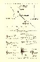 |
Tracings of accelerograph records of Long Beach earthquake of March 10, 1933. In :"Earth Motions in the Vicinity of a Fault Slip" by Nicholas Heck and Frank Neumann, 1942. Bulletin of the Geological Society of America, Vol. 53, pp. 179- 194. |
1942 |
103 |  |
Apparatus for expanding acceleration curves prior to integration. In: "Earth Motions in the Vicinity of a Fault Slip" by Nicholas Heck and Frank Neumann, 1942. Bulletin of the Geological Society of America, Vol. 53, pp. 179- 194. |
1942 |
104 |  |
Resultant horizontal motion at Los Angeles during first 15 seconds of Long Beach earthquake of March 10, 1933. In: "Earth Motions in the Vicinity of a Fault Slip" by Nicholas Heck and Frank Neumann, 1942. Bulletin of the Geological Society of America, Vol. 53, pp. 179- 194. |
1942 |
105 |  |
Artists conception USC&GS OCEANOGRAPHER, largest vessel designed for oceanographic studies in the United States at that time. |
1965 Ca. |
106 |  |
A theodolite magnetometer of Carnegie Institution Department of Terrestrial Magnetism design. |
1930 Ca. |
107 |  |
A contour map presenting the secular change in the vertical intensity of the Earth's magnetic field from 1885 to 1922. |
1940 Ca. |
108 |  |
Chart showing location of land stations and cruises used in mapping the Earth's magnetic field. |
1940 Ca. |
109 |  |
State of advancement of hydrographic surveys of the world, 1904, by George W. Littlehales of the Naval Hydrographic Office. In: "Nautical Charts" by George Rockwell Putnam, 1908. 162 pp. |
1904 |
110 | 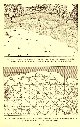 |
Coast Survey chart showing density of soundings from original survey used to to construct nautical chart. Comparing survey of Ponce Harbor, Puerto Rico to published chart of same. In: "Nautical Charts" by George Rockwell Putnam, 1908. 162 pp. |
1908 |
111 |  |
Coast Survey chart showing density of soundings from original survey used to to construct nautical chart. Comparing survey of Ponce Harbor, Puerto Rico to published chart of same. In: "Nautical Charts" by George Rockwell Putnam, 1908. 162 pp. |
1908 |
112 |  |
Coast Survey surveys of Chincoteague Island, Virginia illustrating building out of land areas between 1849 and 1902. In: "Nautical Charts" by George Rockwell Putnam, 1908. 162 pp. |
1908 |
113 |  |
Growth of land at Cubits Gap, Mississippi River Delta, between 1852 and 1905. In: "Nautical Charts" by George Rockwell Putnam, 1908. 162 pp. |
1908 |
114 |  |
Columbia River Entrance showing movement of Sand Island, surveys of 1851, 1870, and 1905. In: "Nautical Charts" by George Rockwell Putnam, 1908. 162 pp. |
1908 |
115 |  |
No cell phones, no roving mechanics in this country. The truck breaks and the surveyors have to fix it. Gravity observation party in Washington state. |
1948 December |
116 |  |
A regular full-color chart is printed on a sheet of plastic and pressed over a steel mold, providing a light, flexible, relief map. |
1945 Ca. |
117 |  |
Longitude and latitude lines are drawn on the Coast and Geodetic Survey projection ruling machine. This machine eliminated thousands of man-hours of drafting time that would have been required to produce the projections made for the thousands of maps produced for the Allied Armed Services during WWII. |
1945 Ca. |
118 |  |
One of thousands of 4- X 6 foot relief models made by Aero for the armed forces is seen here just after removal from the plaster mold. In: Wilson, Don C. 1949. "Production of Plastic Relief Maps" in Surveying and Mapping, Vol. IX, no. 3, pp. 183-186. |
1945 Ca. |
119 |  |
Relief model - a thin gauge aluminum sheet - is formed on the Braund Reliefograph. The "altimeter is seen on the left. In: Wilson, Don C. 1949. "Production of Plastic Relief Maps" in Surveying and Mapping, Vol. IX, no. 3, pp. 183-186. |
1945 Ca. |
120 |  |
Map showing the magnetic observatories of the world. |
1935 Ca. |
121 |  |
Map showing lines of equal magnetic declination as determined by the Coast Survey in 1850. |
1935 Ca. |
122 |  |
Map showing lines of equal magnetic declination as determined by the Coast Survey in 1875. |
1935 Ca. |
123 |  |
Map showing lines of equal magnetic declination and of equal annual change as determined by the Coast and Geodetic Survey in 1935. |
1935 Ca. |
124 |  |
Mixing ink for the Harris presses. |
1935 Ca. |
125 |  |
Harris presses in the press room in the basement of the Department of Commerce Building. |
Washington, D.C. 1935 Ca. |
126 |  |
Harris presses in the press room in the basement of the Department of Commerce Building. |
Washington, D.C. 1935 Ca. |
127 |  |
Two color offset press. One of two presses of this type used by the Coast and Geodetic Survey in its reproduction plant for the printing of aeronautical and nautical charts. In the basement of the the Department of Commerce building. This press has an output of 4,000 impressions per hour. |
Washington, D.C. 1935 Ca. |
128 |  |
A view of the Harris presses in the reproduction plant of the Coast and Geodetic Survey. These presses were in the basement of the Department of Commerce building. |
Washington, D.C. 1935 Ca. |
129 |  |
Coast and Geodetic Survey pressmen in action on a Harris press. |
Washington, D.C. 1935 Ca. |
130 |  |
A view of the Harris presses in the reproduction plant of the Coast and Geodetic Survey. These presses were in the basement of the Department of Commerce building. |
Washington, D.C. 1935 Ca. |
131 |  |
A Harris press in the reproduction plant of the Coast and Geodetic Survey in the basement of the Department of Commerce Building. |
Washington, D.C. 1935 Ca. |
132 |  |
A Harris press to the right and the Seybold-Harris guillotine paper cutter to the left. Note the C&GS logo pressmen shirt on the man on the guillotine. |
Washington, D.C. 1935 Ca. |
133 |  |
Hand-painted blown-up photograph of Cowboy Roy Bixby passing through the redwoods in Palo Colorado Canyon, the furthest south stand of redwoods in California. |
California, Palo Colorado Canyon 1932 |
134 | 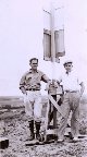 |
Oscar and Floyd Risvold at a station near Monterey. |
California, Near Monterey 1932 spring |
135 |  |
Eccentric target (used for sighting on by theodolite) at Station Heath. Point Sur is visible below and to the right. Lieutenant William Tucker on left, Lieutenant Charles Pierce on right. |
California, Big Sur Coastline 1932 |
136 |  |
Oscar Risvold recording while Lieutenant William Tucker observses angles. |
California, Big Sur area 1932 |
137 |  |
On the march with the building party in the Santa Lucia mountains. Silk Hat Harry Quinlavin on the left, Floyd Risvold on the right. |
California, Santa Lucia Mountains 1932 summer |
138 |  |
The first camp at Big Sur. |
California, Big Sur 1932 first week in July |
139 |  |
The second camp at Big Sur. |
California, Big Sur, California 1932 July |
140 |  |
On the way to a station in the Big Sur country. |
California, Big Sur Coastline area 1932 |
141 |  |
Cowboy Roy Bixby loading a pack horse while Winnie Pierce (Lieutenant Charles Pierce's brother) looks on. |
California, Big Sur Coastline area 1932 |
142 |  |
Silk Hat Harry Quinlavin (without his hat), Cowboy Roy Bixby, and Lieutenant William Tucker in Big Sur country. |
California, Santa Lucia Mountains 1932 |
143 |  |
Observing party on the way to a station in the Coast mountains. Cowboy Roy Bixby holding horses tail, Lieutenant Charles Pierce in the lead, and Lieutenant William Tucker. |
California, Santa Lucia Mountains 1932 |
144 |  |
Mule waiting to be loaded on truck for transport. One day as Oscar Risvold was waiting for the truck to back up to a road bank, the mule moved forward and jumped on board the truck just like a cat! |
California, Big Sur area 1932 |
145 |  |
Roy Bixby, the Cowboy, loading a mule. Both mules used had a heavy coat of hair as shiny as fur. |
California, Big Sur area 1932 |
146 |  |
Mule jumping on truck. After the first mule had jumped on the truck, the second mule followed with a little tug on the bridle. Pierce's crew had two mules and a number of horses from the Castro Ranch, one of the pioneer families in the Big Sur area. After reaching San Simeon the horses were returned but the party kept the mules a little longer. |
California, Big Sur area 1932 |
147 |  |
The truck was usually backed up to a road bank to make it easy for the mules to board. Sometimes there would be problems. L to R - mule fallen between truck and road bank, Lieutenant William Tucker, Jack Bachtel, and Silk Hat Harry Quinlavin. |
California, Big Sur area 1932 |
148 |  |
Loading the horses, the survey crew would back the truck up to a road bank and they would walk on board. When the crew got to the end of truck travel, they would unload on a road bank. There were always road banks in that country! |
California, Big Sur area 1932 |
149 |  |
L to R Jack Marx, Oscar Risvold, and Silk Hat Harry Quinlavin in Big Sur country . |
California, Big Sur area 1932 |

