Emergency Management News Updated April 14, 2008
This web page is dedicated to information important to emergency managers, spotter group coordinators, and other user groups interested in the latest news from the National Weather Service in Green Bay. If you have any questions, contact Jeff Last <jeff.last@noaa.gov>
Severe Weather Awareness
Posted April 14, 2008
Wisconsin's Severe Weather Awareness Week was April 21-25, 2008. Staying safe in severe weather begins with preparation and knowing what to do when storms threaten. The National Weather Service has a severe weather safety page with tips and information here.
Spotter Training Schedule Online
Posted Jan 8, 2008
Spotter talks are typically scheduled during the winter and early spring--the training season usually runs from March-May. Check the latest schedule by clicking here. Please make sure all spotters, law enforcement, and first responders are aware of the training for your area.
Rare January Tornado Hits Southeast Wisconsin
Posted Jan 8, 2008
On January 7, 2007, for only the second time in over 100 years of Wisconsin January tornado records, a tornado was reported in the state; in fact, two tornadoes hit Kenosha County. The hardest hit area was the town of Wheatland in Kenosha County, where over two dozen homes were damaged or destroyed. A tornado intensity rating of EF3 has been assigned to the larger of the two twisters. For more information on the rare January tornado outbreak, click here.
Storm-Based Warnings--What Changed?
Posted Oct 1, 2007
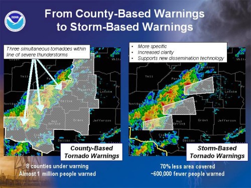
The National Weather Service (NWS) in Green Bay officially began issuing Storm-Based Warnings in late September 2007. As a matter-of-fact, the NWS Green Bay office has been transitioning to storm-based alerts for several years.
Instead of selecting whole counties ahead of a storm, we are warning based on a threat area (in the shape of a polygon) ahead of the storm. If that threat area touches a section of the county, it is specifically listed in the actual written warning.
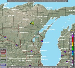
Look at the example below. Notice how the threat area (polygon) only covers a small section of two counties (southeast Forest and northern Oconto). Far fewer people are actually under a Severe Thunderstorm Warning compared with if both counties were warned in their entirety.
(Click to enlarge)
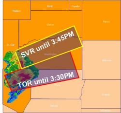
Issuing warnings based on storms (and not on counties) means you could have two warnings in effect for the same county. For example, you could have a threat area in the northern half of the county and a second, separate storm in the extreme southeast part.
(Click to enlarge)
So, there isn't much of a change from what we used to do. Warnings still list counties or sections of counties under a severe weather threat. In addition, warnings are a bit more detailed and centered on the main threat area. Storm-based warnings offer much more flexibility and a more accurate depiction of what is expected. Cell phones, PDAs, and GIS-enabled systems can take advantage of the warning area latitude/longitude information contained in the storm-based alerts. Software is already being developed by private weather companies that will take the storm-based warning information and tie that in with county siren systems.
Additional information on storm-based warnings can be found by clicking here.
Summaries of Major Northeast Wisconsin Weather Events Online
Posted August 30, 2007
After significant weather events, summaries are often placed online on our website. For a list of links to summaries of significant weather events and other interesting phenomena, visit our "Neat Stuff" page by clicking here.
Plan, Practice, Monitor, and Act
Posted April 20, 2007
Do businesses, churches, schools, and gathering places in your county have a severe weather safety plan? Click here for a weather safety plan outline.
Tornado Safety in Schools
Posted Mar 5, 2007
The tragedy at Enterprise High School in Alabama on March 1, 2007, brings to the forefront the destructive power of tornadoes. FEMA has a publication "Tornado Protection: Selecting Refuge Areas in Buildings" that will help in reviewing buildings for the purpose of selecting areas that are likely to be most resistant to tornadoes and high winds. Additional information is available on our School Preparedness Guide web site: www.weather.gov/grb/?n=schools
The Enhanced Fujita Scale
Posted Feb 5, 2007
On February 1, 2007, the National Weather Service fully implemented the Enhanced Fujita (EF) Scale to rate tornadoes, replacing the original Fujita Scale. The EF Scale will continue to rate tornadoes on a scale from zero to five, but ranges in wind speed will be more accurate with the improved rating scale. For more information, click here.
Warning and Advisory Tip Sheet
Posted Jan 23, 2007
Did you ever want to know when exactly a Snow and Blowing Snow Advisory might be issued? Or what the difference is between a Heat Advisory and a High Heat Warning? A list of advisories and warnings issued by the NWS Green Bay are available on a single sheet by clicking here (PDF format).


