| News - updated January 8,2013 |
|
Page Loading - Please Wait...
The U.S. Geological Survey (USGS) will discontinue operation of up to 375 streamgages nationwide due to budget cuts as a result of sequestration. Additional streamgages may be affected if partners reduce their funding to support USGS streamgages. The USGS is working to identify which streamgages will be impacted and will post this information as it becomes available. Streamgages are used nationwide to predict and address drought and flood conditions by monitoring water availability. The USGS and over 850 Federal, State, and local agencies cooperatively fund the USGS streamgaging network, which consists of over 8,000 streamgages. When budgets fluctuations occur, the network is impacted. Specific impacts to the Florida Current Conditions Network currently are not known.
PROVISIONAL DATA SUBJECT TO REVISION |
||||
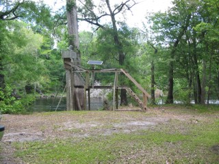
LOCATION.--Lat 29°50'55", long 82°42'55", referenced to North American Datum of 1927, in SE 1/4 sec.28, T.7 S., R.16E., Gilchrist County, Hydrologic Unit 03110206, on left bank 2.1 mi upstream from bridge on State Highway 47, 5.1 mi south of Fort White, and 18 mi upstream from mouth. PERIOD OF RECORD.--October 1927 to January 1930, June 1932 to current year. GAGE.--Water-stage recorder. Datum of gage is 20.86 ft above NGVD of 1929 (levels by U.S Army Corps of Engineers). Prior to June 3, 1932, nonrecording gage at several sites within 200 ft of present site at various datums Oct. 1, 1947 to Feb. 10, 1949, auxiliary nonrecording gage and since Feb. 11, 1949, auxiliary water-stage recorder at bridge on U.S. Highway 129, 16 mi downstream from base gage at datum 3.5 ft above NGVD of 1929.
|
||||
| Summary of all available data for this site | ||||
| Instantaneous-data availability statement |
Discharge, cubic feet per second |
|||||||||||||||
|
|||||||||||||||
|
|||||||||||||||
Gage height, feet, Pressure Transducer |
|||||||||
|
|||||||||
| Questions about sites/data? | Data Tips | |
| Feedback on this web site | Explanation of terms | |
| Automated retrievals | Subscribe for system changes | |
| Help | News | |
![]()
![]() U.S. Department of the Interior |
U.S. Geological Survey
U.S. Department of the Interior |
U.S. Geological Survey
Title: USGS Current Conditions for Florida
URL: http://waterdata.usgs.gov/fl/nwis/uv?
Page Contact Information: Florida Water Science Center - Tallahassee Water Data Support Team
Page Last Modified: 2013-03-20 19:18:58 EDT
0.93 0.84 vaww02