
 Feeds & Data
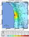
Magnitude 6.3 - TARAPACA, CHILE
2008 February 04 17:01:29 UTC
Earthquake Details
| Magnitude | 6.3 |
|---|---|
| Date-Time |
|
| Location | 20.123°S, 70.000°W |
| Depth | 32.3 km (20.1 miles) |
| Region | TARAPACA, CHILE |
| Distances | 15 km (10 miles) ENE of Iquique, Chile 185 km (115 miles) S of Arica, Chile 215 km (135 miles) N of Tocopilla, Chile 1470 km (920 miles) N of SANTIAGO, Chile |
| Location Uncertainty | horizontal +/- 7.7 km (4.8 miles); depth +/- 18.7 km (11.6 miles) |
| Parameters | NST=181, Nph=181, Dmin=298 km, Rmss=0.91 sec, Gp= 47°, M-type=moment magnitude (Mw), Version=R |
| Source |
|
| Event ID | us2008naa1 |
- This event has been reviewed by a seismologist.
- Did you feel it? Report shaking and damage at your location. You can also view a map displaying accumulated data from your report and others.
Earthquake Summary


The following is a revised REPEAT revised release by the United States Geological Survey, National Earthquake Information Center: An earthquake occurred about 40 km (25 miles) ENE of Iquique at 10:01 AM MST, Feb 4, 2008 (2:01 PM local time in Chile). The magnitude and location may be revised when additional data and further analysis results are available. There have been no reports of damage.
Felt Reports
Felt (V) at Alto Hospicio, Huara, Iquique and Pozo Almonte; (IV) at Arica and Camarones; (II) at Antofagasta. Felt at Calama. Felt (III) at Tacna, Peru.
Earthquake Maps


Scientific & Technical Information

- Preliminary Earthquake Report
- U.S. Geological Survey, National Earthquake Information Center:
World Data Center for Seismology, Denver
