
 Feeds & Data
Magnitude 7.5 - MOLUCCA SEA
2007 January 21 11:27:45 UTC
Earthquake Details
| Magnitude | 7.5 |
|---|---|
| Date-Time |
|
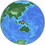
| Location | 1.222°N, 126.395°E |
| Depth | 22 km (13.7 miles) set by location program |
| Region | MOLUCCA SEA |
| Distances | 125 km (80 miles) WNW of Ternate, Moluccas, Indonesia 165 km (105 miles) ESE of Manado, Sulawesi, Indonesia 1605 km (1000 miles) SSE of MANILA, Philippines 2310 km (1430 miles) ENE of JAKARTA, Java, Indonesia |
| Location Uncertainty | horizontal +/- 6.8 km (4.2 miles); depth fixed by location program |
| Parameters | NST=155, Nph=155, Dmin=>999 km, Rmss=1.13 sec, Gp= 32°, M-type=teleseismic moment magnitude (Mw), Version=S |
| Source |
|
| Event ID | us2007xvam |
- This event has been reviewed by a seismologist.
- Did you feel it? Report shaking and damage at your location. You can also view a map displaying accumulated data from your report and others.
Earthquake Summary

The following is a release by the United States Geological Survey, National Earthquake Information Center: A major earthquake occurred 130 km (80 miles) WNW of Ternate, Moluccas, Indonesia 165 km (100 miles) E of Manado, Sulawesi, Indonesia at 5:27 AM MDT, Jan 21, 2007 (6:54 PM local time in Molucca Sea). The magnitude and location may be revised when additional data and further analysis results are available. No reports of damage or casualties have been received at this time; however, this earthquake may have caused damage due to its location and size.
Felt Reports
One person died of a heart attack, 3 others killed, 4 others injured and minor damage to some buildings at Mandano, Sulawesi, Indonesia. Felt (VI) on Ternate; (VI) at Bitung and Tondano, (V) at Kotamobagu, (IV) at Gorontalo, Sulawesi; (IV) in southern Halmahera, Indonesia.
Earthquake Information for Asia
Earthquake Information for Indonesia
 Tsunami Information
- NOAA Tsunami Warning Center
- Recent Tsunamis
- Tsunami Information Links
The earthquake locations and magnitudes cited in these bulletins are very preliminary, and may disagree with the more accurate USGS locations and magnitudes computed using more extensive data sets.
Earthquake Maps


Scientific & Technical Information

- Preliminary Earthquake Report
- U.S. Geological Survey, National Earthquake Information Center:
World Data Center for Seismology, Denver
