
 Feeds & Data
Magnitude 6.8 - PERU-ECUADOR BORDER REGION
2007 November 16 03:13:00 UTC
Earthquake Details
| Magnitude | 6.8 |
|---|---|
| Date-Time |
|
| Location | 2.271°S, 77.804°W |
| Depth | 123 km (76.4 miles) set by location program |
| Region | PERU-ECUADOR BORDER REGION |
| Distances | 115 km (70 miles) SE of Riobamba, Ecuador 140 km (90 miles) ENE of Cuenca, Ecuador 145 km (90 miles) SE of Ambato, Ecuador 240 km (150 miles) SSE of QUITO, Ecuador |
| Location Uncertainty | horizontal +/- 4.6 km (2.9 miles); depth fixed by location program |
| Parameters | NST=292, Nph=292, Dmin=286.3 km, Rmss=0.89 sec, Gp= 29°, M-type=moment magnitude (Mw), Version=R |
| Source |
|
| Event ID | us2007juaf |
- This event has been reviewed by a seismologist.
- Did you feel it? Report shaking and damage at your location. You can also view a map displaying accumulated data from your report and others.
Earthquake Summary


The following is a release by the United States Geological Survey, National Earthquake Information Center: An earthquake occurred about 115 km (75 miles) SE of Riobamba, Ecuador or about 245 km (150 miles) SSE of QUITO, Ecuador at 8:12 PM MST, Nov 15, 2007 (10:12 PM local time in Ecuador). The magnitude and location may be revised when additional data and further analysis results are available.
Felt Reports
Minor damage at Guayaquil, Ecuador. Felt (IV) at Santa Maria de Nieva, Peru. Felt at Iquitos, Jaen, Moyabamba, Piura, Trujillo and Tumbes, Peru. Felt at Ambato, Jaramijo, Latacunga, Loja, Machala, Morona, Portoviejo, Quito and Riobamba, Ecuador. Felt strongly in much of Ecuador and northern Peru.
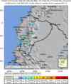
Earthquake Maps


Scientific & Technical Information

- Preliminary Earthquake Report
- U.S. Geological Survey, National Earthquake Information Center:
World Data Center for Seismology, Denver
