
 Feeds & Data
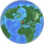
Magnitude 4.8 - ENGLAND, UNITED KINGDOM
2008 February 27 00:56:45 UTC
Earthquake Details
| Magnitude | 4.8 |
|---|---|
| Date-Time |
|
| Location | 53.321°N, 0.314°W |
| Depth | 10 km (6.2 miles) set by location program |
| Region | ENGLAND, UNITED KINGDOM |
| Distances | 40 km (25 miles) S of Kingston upon Hull, England, UK 75 km (45 miles) NE of Nottingham, England, UK 80 km (50 miles) E of Sheffield, England, UK 210 km (130 miles) N of LONDON, United Kingdom |
| Location Uncertainty | horizontal +/- 6.8 km (4.2 miles); depth fixed by location program |
| Parameters | NST= 50, Nph= 50, Dmin=291.4 km, Rmss=1.02 sec, Gp= 54°, M-type=body magnitude (Mb), Version=7 |
| Source |
|
| Event ID | us2008nyae |
- This event has been reviewed by a seismologist.
- Did you feel it? Report shaking and damage at your location. You can also view a map displaying accumulated data from your report and others.
Earthquake Summary

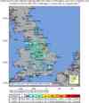
Felt Reports
One person injured and damage to buildings in the Lincolnshire and South Yorkshire areas. Felt (V) at Barnsley, Bedworth, Beeston and Stapleford, Bentley, Beverley, Bicester, Boston, Brigg, Brighouse, Chesterfield, Chorley, Cleethorpes, Doncaster, Droitwich, East Retford, Eaton Socon-Saint Neots, Failsworth, Grantham, Grimsby, Heywood, Hinckley, Ilkeston, Kirby in Ashfield, Leicester, Lincoln, Long Eaton, Loughborough, Mablethorpe and Sutton, Matlock, Melton Mowbray, Mold, Morley, Oakham, Rotherham, Sheffield, Skegness, Sleaford, Spalding-Pinchbeck, Whitefield and Worksop. Felt widely in the United Kingdom, north to Arbroath, southwest to Falmouth-Penrynm and east to Great Yarmouth. Felt (II) at Gent, Belgium. Also felt at Douglas, Isle of Man; at Antwerp and Brussels, Belgium; and at Aniche, France.
Earthquake Maps


Scientific & Technical Information
Additional Information, News Reports
- Preliminary Earthquake Report
- U.S. Geological Survey, National Earthquake Information Center:
World Data Center for Seismology, Denver
