
 Feeds & Data
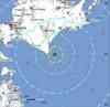
Magnitude 6.8 - HOKKAIDO, JAPAN REGION
2008 September 11 00:20:52 UTC
Earthquake Details
| Magnitude | 6.8 |
|---|---|
| Date-Time |
|
| Location | 41.976°N, 143.630°E |
| Depth | 35 km (21.7 miles) set by location program |
| Region | HOKKAIDO, JAPAN REGION |
| Distances | 125 km (80 miles) SSW of Kushiro, Hokkaido, Japan 225 km (140 miles) SSE of Asahikawa, Hokkaido, Japan 225 km (140 miles) ESE of Sapporo, Hokkaido, Japan 775 km (485 miles) NNE of TOKYO, Japan |
| Location Uncertainty | horizontal +/- 7.7 km (4.8 miles); depth fixed by location program |
| Parameters | NST=184, Nph=185, Dmin=0 km, Rmss=1.21 sec, Gp= 0, M-type=regional moment magnitude (Mw), Version=8 |
| Source |
|
| Event ID | us2008wvag |
- This event has been reviewed by a seismologist.
- Did you feel it? Report shaking and damage at your location. You can also view a map displaying accumulated data from your report and others.


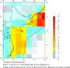
Earthquake Maps


Scientific & Technical Information
 USGS Centroid Moment Tensor Solution
- Global CMT Project Moment Tensor Solution
- USGS Body-Wave Moment Tensor Solution
- Historic Moment Tensor Solutions
- Phase Data
- Seismicity Cross Section
- Seismic Record Section
- Theoretical P-Wave Travel Times
- Energy and Broadband Solution
- Subduction Zone Geometry Analysis
Additional Information, News Reports
- Preliminary Earthquake Report
- U.S. Geological Survey, National Earthquake Information Center:
World Data Center for Seismology, Denver
