Printable Maps

Do you need a simple prepared map that you can print at home, at school, or in the office? Look below at our expanding list of maps formatted to be viewed, printed, or downloaded.
| Home › Printable Maps › Elections | ||
Printable Maps |
||
|
Do you need a simple prepared map that you can print at home, at school, or in the office? Look below at our expanding list of maps formatted to be viewed, printed, or downloaded. |
||
| Presidential Elections 1789 - 2000 | |||||||||||||||||||||||||||||||||||||||||||||||||||||||
 Go to map list
 |
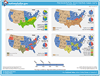
The National Atlas offers a wall map, Presidential Elections 1789-2000, which has also been reformatted into 14 pages designed to be viewed and downloaded from the Web. These Presidential Elections printable maps show electoral votes won, by political party, for the fifty-four Presidential elections from George Washington in 1789 to George W. Bush in 2000. The maps are grouped four or six to a page and show electoral vote results by State. The map for 2000 is also offered on a page by itself, showing popular vote results by county as well as electoral vote results by State. These map pages are in a standard 8.5- by 11-inch landscape format. The maps are available in the following formats.
|
||||||||||||||||||||||||||||||||||||||||||||||||||||||
|
|||||||||||||||||||||||||||||||||||||||||||||||||||||||
National Atlas of the United States® and The National Atlas of the United States of America® are registered trademarks of the United States Department of the Interior Privacy Statement, Disclaimer, Accessibility, FOIA http://nationalatlas.gov/printable/elections.html Last modified: Tuesday April 29 2008 |
 |
|
;)
;)
;)
;)
;)
;)
;)
;)
;)
;)
;)
;)
;)
;)