Abandoned Mine Lands
Ore deposit research, geochemical modeling, and remote sensing are used to understand the impact of historic mining and prioritize remediation

An abandoned hard-rock metal mine.
Thousands of abandoned hard-rock metal mines (such as gold, copper, lead, and zinc) have left a dual legacy across the Western United States. They reflect the historic development of the West; yet at the same time represent a possible threat to human health and local ecosystem. According to a 1996 GAO report, thousands of abandoned hard rock mines exist on Federal lands; many of which constitute physical safety or environmental degradation hazards. The GAO report also indicates that 50-billion tons of mine waste (enough to fill 2,400 football fields, each one-mile high) have been generated, 14,400 sites need extensive work to prevent surface-water contamination, and 5,000 miles of streams are affected by acid drainage.

Acid-mine drainage down a slope at
Bullion Mine near Boulder River, Montana.
The majority of Abandoned Mine Lands (AML) in the Nation are on, or bordered by, land managed by Federal land management agencies, including the Bureau of Land Management (BLM), the USFS, and the National Park Service. This initiative is part of a larger strategy by DOI and U.S. Department of Agriculture to coordinate activities for the cleanup of Federal lands affected by AML. The success of this initiative depends upon an interdisciplinary team of scientists working together with Federal land managers to provide science-based solutions to AML reclamation.
Abandoned Mine Lands often contain un-mined mineral deposits, mine dumps, and tailings that contaminate the surrounding watershed and ecosystem.
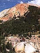

A mountain landscape depicting mining
and non-mining sources of metals
and acid water near Silverton, CO.
Two pilot watershed studies- Upper Animas River Basin and Boulder River Basin:
The USGS AML Initiative began in 1997 in two pilot watersheds - the upper Animas River basin, near Silverton, in southwestern Colorado and the Boulder River basin in southwestern Montana, about 25 miles south of Helena. The Federal land management agencies, the Colorado Water Quality Control Commission, and the Montana Department of Environmental Quality directed the prioritization and selection of the pilot watersheds. Information developed in existing USGS programs was used in part to accomplish these selections. Both areas have a long history of mining dating back to late 1800's. Principal metals included gold, silver, lead, and zinc. Ore bodies are sulfidic and acid mine drainage occur in both areas. Some mine, mill, and smelter sites and tailings deposits, along with eroded tailings distributed along various reaches of stream channels and flood plains, are located on land administered by USFS and BLM.
The AML project goal is to characterize the controlling geological, geochemical, and geophysical factors within a watershed, identify and prioritize the major contributors of acid mine drainage and toxic metals, and to transfer this information in the form of environmental geologic maps to Federal land management agencies, State and local governments, and aquatic and wildlife habitat managers within the entire watershed.
USGS Science Research

Flood-plain tailings along Jack Creek,
eroding into a near-by stream.
USGS ecologists, geologists, water quality experts, hydrologists, geochemists, and mapping and digital data collection experts are collaborating to provide the scientific knowledge needed for an effective cleanup of AML's. Within the selected watershed, the USGS collects preliminary monitoring data. This includes developing a conceptual understanding of sites and potential processes that control the occurrence and transport of contaminants, identifying sites that have the greatest possibility of having deleterious effects of water quality and biota, and where possible, estimating the magnitude of the effects.
Measurement of water quality and quantity in both pilot watersheds has made possible the study of seasonal and other temporal variations in the movement of contaminants. For example, these studies showed that on approximately 354 days a year, zinc levels in the upper Animas River exceeded the standards proposed by the Colorado Water Quality Division.


USGS scientists collecting samples from stream and river-bed impacted by mining activity.
Tracer tests, in which harmless tracer, such as dye, is put into a stream and its downstream movement measured and modeled, are successfully identifying the largest sources of AML contamination and enabling efficient targeting of cleanup activities.
Metal concentrations in fish and invertebrates in the two pilot watersheds were found to be higher than in the surrounding water and bottom sediments. These measurements show that metals (some of which are toxic) are accumulating in the local food chain. Researchers have also determined how these metals (such as cadmium, copper, lead, and zinc) move downstream to settle and accumulate in the bottom sediment of rivers and streams.
In some cases, water quality near AML's was affected by natural weathering of mineral deposits before mining occurred. Because of this, scientists are working to determine the environmental conditions that existed before mining began to establish realistic cleanup goals for an area. Mapping of the two AML sites has identified those areas where land surfaces and stream channels have been affected by historic mining activities.

An image of a southwestern Montana valley where an active creek
has eroded a channel through mine tailings, carrying them to a nearby river.
Remote sensing mineral mapping via imaging spectroscopy (AVIRIS) provides a powerful technique for locating sources of acidic and acid-buffering drainage of either natural or anthropogenic origin. Pyrite weathering products and acid-buffering minerals are distinguishable in AVIRIS spectra. Field studies have confirmed the presence of all the mineralogies presented in this study, and geochemistry studies within the basin corroborate the findings and indicate a strong link between acid-buffering assemblages and water quality. This approach will be extremely useful to property owners interested in assessing and remediation of land affected by acidic drainage.
Data obtained are being used in conjunction with field geologic mapping, geochemistry and geophysics to determine the relative extent of natural and anthropogenic sources of acid water runoff, and their effect of water quality.

An AVIRIS image of the Silverton area showing acid-buffering minerals (Dalton, et.al., 1999)
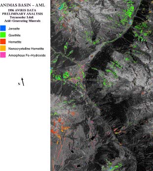
Another AVIRIS image of the Silverton area showing acid-generating minerals. (Dalton, et.al., 1999)
The AML is in the final year of a five-year project. The focus for the final year will be on completing many of the individual reports of activities and integration of the results obtained to address the fundamental questions of source, transport, and fate of metals in the watershed and their individual and cumulative impact of the aquatic and riparian habitat. The basic geologic framework has been synthesized from existing mapping and the hydrothermal alteration suites evaluated from surface mapping and AVIRIS data. The GIS coverage of these geospatial data for use by the Federal land management agencies, the public, and the private industry in remediation and management of Federal lands is in preparation.
