The A-Train Observes Tropical Storm Debby
|
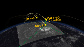
The A-Train is a group of spacecraft flying in close formation allowing data taken by each instrument to be correlated to the other instruments providing data synergy. The A-Train includes Aqua, CloudSat, CALIPSO, Parasol, and Aura. The animation begins showing the Earth with moving clouds and with a day/night terminator. Time slows down, and A-train spacecraft orbits are added during a daytime pass. The orbits progress around the globe for 12 hours. During a night time pass the camera zooms into Tropical Storm Debby as the A-train flies over on August 24, 2006. Data sets from some of the A-train's spacecraft/instruments are shown including Aqua/MODIS, CloudSat, CALIPSO, and Aqua/AIRS. This visualization was created to support an A-Train session at the 2007 International Geoscience and Remote Sensing Symposium (IGARSS).
|
|

|
|
The A-Train observes Tropical Storm Debby
Duration: 2.0 minutes
Available formats:
1280x720 (30 fps)
MPEG-4
42 MB
1280x720 (30 fps)
MPEG-2
119 MB
640x360 (30 fps)
MPEG-4
21 MB
512x288 (30 fps)
MPEG-1
32 MB
1280x720 (29.97 fps)
Frames
320x180
PNG
164 KB
160x80
PNG
40 KB
80x40
PNG
11 KB
How to play our movies
|
|
|
|
The A-train flys over Tropical Storm Debby on August 24, 2006.
Available formats:
3840 x 2160
TIFF
3 MB
320 x 180
PNG
166 KB
|
|

|
|
MODIS data of Tropical Storm Debby.
Available formats:
3840 x 2160
TIFF
4 MB
320 x 180
PNG
156 KB
|
|

|
|
Cloudsat and CALIPSO data of Tropical Storm Debby.
Available formats:
3840 x 2160
TIFF
6 MB
320 x 180
PNG
209 KB
|
|

|
|
AIRS water vapor data of Tropical Storm Debby.
Available formats:
3840 x 2160
TIFF
5 MB
320 x 180
PNG
218 KB
|
|
|
Back to Top
|

