
Click on image for animation of
3-dimensional model with 5x vertical exaggeration
This image of chaotic terrain in the Aureum Chaos region of Mars was taken
by the Compact Reconnaissance Imaging Spectrometer for Mars (CRISM) at
0858UTC (3:58 a.m. EST) on January 24, 2008, near 3.66 degrees south
latitude, 26.5 degrees west longitude. The image was taken in 544 colors
covering 0.36-3.92 micrometers, and shows features as small as 18 meters
(60 feet) across. The image is about 10 kilometers (6.2 miles) wide at its
narrowest point.
Aureum Chaos is a 368 kilometer (229 mile) wide area of chaotic terrain in
the eastern part of Valles Marineris. The chaotic terrain is thought to
have formed by collapse of the surrounding Margaritifer Terra highland
region. Aureum Chaos contains heavily eroded, randomly oriented mesas,
plateaus, and knobs—many revealing distinct layered deposits along
their slopes. These deposits may be formed from remnants of the collapsed
highlands, sand carried by Martian winds, dust or volcanic ash that
settled out of the atmosphere, or sediments laid down on the floor of an
ancient lake.
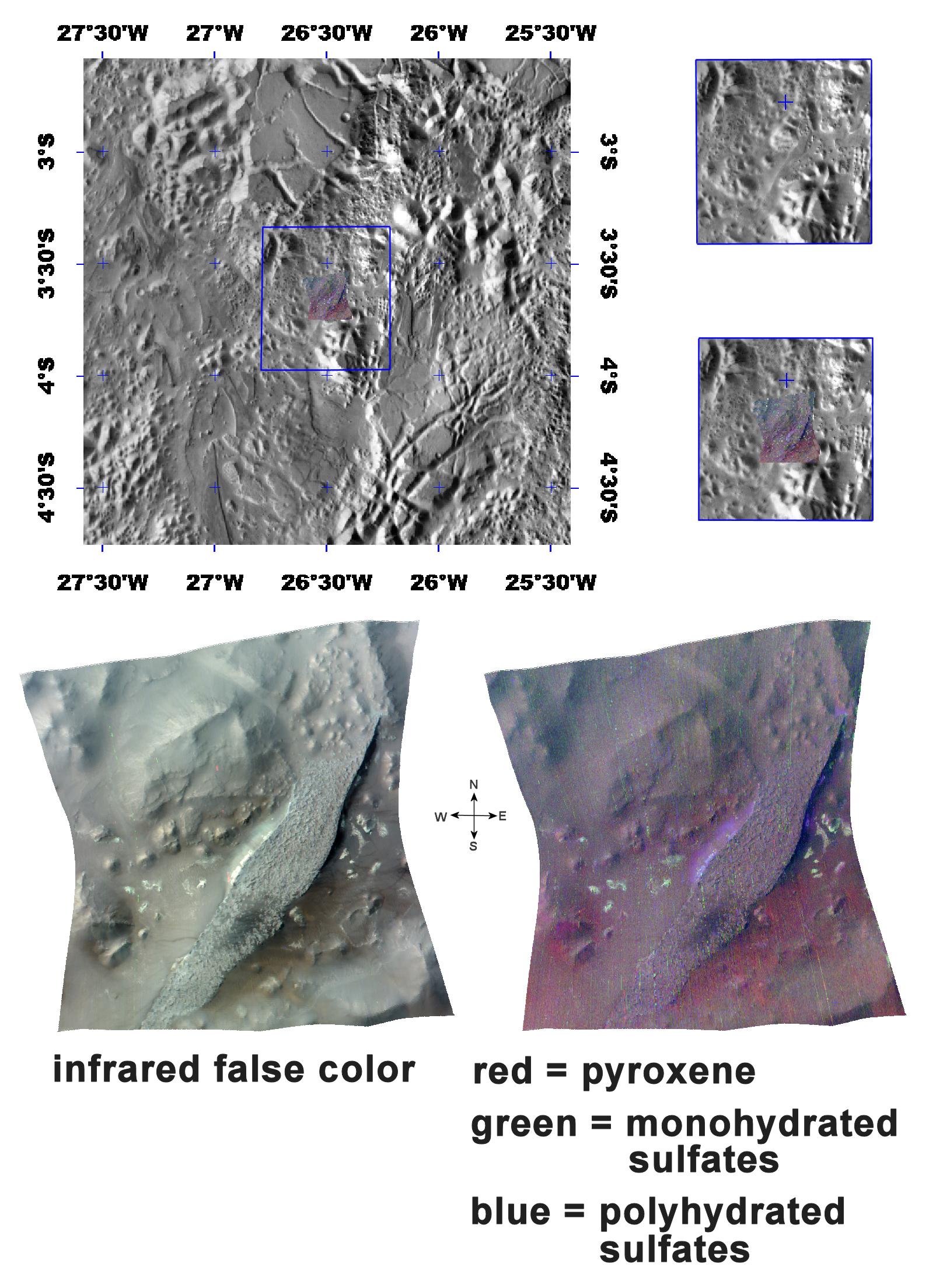
The top panel in the montage above shows the location of the CRISM image
on a mosaic taken by the Mars Odyssey spacecraft’s Thermal Emission
Imaging System (THEMIS). The CRISM data cover a narrow plateau near the
edge of the chaotic terrain, that stretches across from the southwest to
the northeast.
The lower left image, an infrared false color image, reveals the plateau
and several eroded knobs of varying sizes. The plateau’s layer-cake
structure is similar to that of other layered outcrops in Valles
Marineris.
The lower right image reveals the strengths of mineral spectral features
overlain on a black-and-white version of the infrared image. Areas shaded
in red hold more of the mineral pyroxene, a primary component of basaltic
rocks that are prevalent in the highlands. Spots of green indicate
monohydrated sulfate minerals (sulfates with one water molecule
incorporated into each molecule of the mineral), while blue indicates
polyhydrated sulfate minerals (sulfates with multiple waters per mineral
molecule).
Although the plateau’s dark cap rock is somewhat mineralogically
non-descript, the bright, white swath of underlying material cascading
down the plateau’s flanks appears to hold polyhydrated sulfates. Dark
eolian or wind deposited sediments in the south-central part of the
plateau are also rich in polyhydrated sulfates.
Surrounding the plateau are small greenish spots of monoyhydrated
sulfates. These are erosional remnants of an even lower part of the
layered deposits that is compositionally distinct from the main part of
the plateau.
The deepest layer visible is preexisting "basement" rock that forms the
floor of Aureum Chaos around the plateau. It is comprised of basaltic rock
exposed by collapse of the crust and the debris derived from that
collapse.
The animation (see above) of a 3-dimensional topographic model illustrates
the relationship of these materials. It was made using the lower right
CRISM image, draped over MOLA topography with 5X vertical exaggeration.
CRISM is one of six science instruments on NASA's Mars Reconnaissance
Orbiter. Led by The Johns Hopkins University Applied Physics Laboratory,
Laurel, Md., the CRISM team includes expertise from universities,
government agencies and small businesses in the United States and abroad.
NASA's Jet Propulsion Laboratory, a division of the California Institute
of Technology in Pasadena, manages the Mars Reconnaissance Orbiter and the
Mars Science Laboratory for NASA's Science Mission Directorate,
Washington. Lockheed Martin Space Systems, Denver, built the orbiter.
