
Click on the image for August 3, 2004 movie,
slicing down the atmosphere with the AIRS infrared sensor
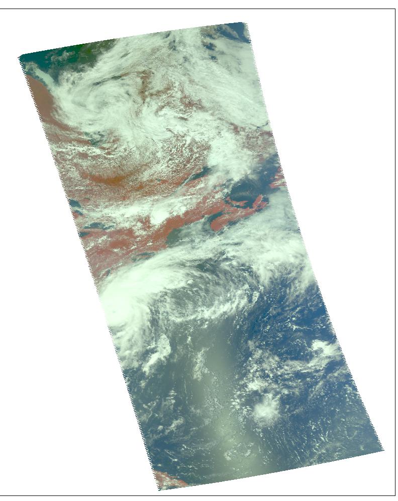
These images of hurricane Alex were captured on August 3, 2004 at 1:30pm
EDT. Located in the Atlantic Ocean located about 80 miles south-southeast
of Charleston, South Carolina, Alex is now a category 2 hurricane with
maximum sustained winds were near 100 mph (161 kph). Alex's center was
about 65 miles (104 kilometers) northeast of Cape Hatteras and moving away
from the U.S. coast.
The major contribution to radiation (infrared light) that AIRS infrared
channels sense comes from different levels in the atmosphere, depending
upon the channel wavelength. To create the movies, a set of AIRS infrared
channels were selected which probe the atmosphere at progressively deeper
levels. If there were no clouds, the color in each frame would be nearly
uniform until the Earth's surface is encountered. The tropospheric air
temperature warms at a rate of 6 K (about 11 F) for each kilometer of
descent toward the surface. Thus the colors would gradually change from
cold to warm as the movie progresses.
Clouds block the infrared radiation. Thus wherever there are clouds we can
penetrate no deeper in infrared. The color remains fixed as the movie
progresses, for that area of the image is "stuck" to the cloud top
temperature. The coldest temperatures around 220 K (about -65 F) come
from altitudes of about 10 miles.
We therefore see in a 'surface channel' at the end of the movie, signals
from clouds as cold as 220 K and from Earth's surface at 310 K (about 100
F). The very coldest clouds are seen in deep convection thunderstorms over
land.
Images

August 2, 2004, 1:30am ET
Frame from August 2 movie, slicing down the atmosphere with the AIRS
infrared sensor. Alex a tropical storm, sustained winds at 60 mph. The
storm is 115 miles southeast of Charleston, South Carolina, traveling
northeast at 6 mph.

August 1, 2004, 1:30am ET
Daylight snapshot from AIRS visible/near-infrared. At the time AIRS made
this observation, Alex was still a tropical depression and just getting
organized.
Movies
Slice down the atmosphere with the AIRS infrared sensor.

August 3, 2004, 1:30am ET
Alex becomes the first hurricane of the 2004 North Atlantic season with
sustained winds at 75 mph.

August 2, 2004, 1:30pm ET
Alex is located about 120 miles southeast of Charleston, South Carolina.
Alex has now begun to move to the northeast and a general northeastward
track is expected the next couple of days with a gradual acceleration in
forward speed as it begins to interact with stronger upper level winds.

August 2, 2004, 1:30am ET
Alex now has sustained winds of 35 knots.

August 1, 2004, 1:30pm ET
Alex is tropical depression and beginning to get organized.
The Atmospheric Infrared Sounder Experiment, with its visible, infrared,
and microwave detectors, provides a three-dimensional look at Earth's
weather. Working in tandem, the three instruments can make simultaneous
observations all the way down to the Earth's surface, even in the presence
of heavy clouds. With more than 2,000 channels sensing different regions
of the atmosphere, the system creates a global, 3-D map of atmospheric
temperature and humidity and provides information on clouds, greenhouse
gases, and many other atmospheric phenomena. The AIRS Infrared Sounder
Experiment flies onboard NASA's Aqua spacecraft and is managed by NASA's
Jet Propulsion Laboratory, Pasadena, Calif., under contract to NASA. JPL
is a division of the California Institute of Technology in Pasadena.


