Skip all navigation and jump to content Jump to site navigation Jump to section navigation.
NASA Logo - Goddard Space Flight Center + Visit NASA.gov
HOME PROJECTS RESOURCES SEARCH MAP

+ Advanced Search
Home
Home
View Most Recently Released Imagery
View Gallery of Imagery: A topical collection of SVS Imagery
Search Imagery by the keywords assigned to it
Search Imagery by the instruments that supplied data for a visualization product
Search Imagery by the series of visualizations that have been produced
Search Imagery by the scientist providing the data used in a visualization product
Search Imagery by the animator that created the product
Search Imagery by the identification number assigned to the visualization product
See other search options
Learn about the SVS Image Server
  + About the Server
  + Animation List
  + How to Use the Server


  + RSS Feeds
  + Podcasts


  + Opportunities
blank image
Previous Animation
Next Animation
AMSR-E Arctic Sea Ice: 2005 to 2008 - Stereoscopic Version

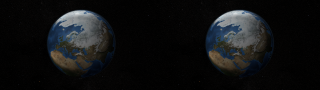
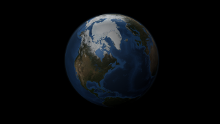
Sea ice is frozen seawater floating on the surface of the ocean. Some sea ice is semi-permanent, persisting from year to year, and some is seasonal, melting and refreezing from season to season. The sea ice cover reaches its minimum extent at the end of each summer and the remaining ice is called the perennial ice cover.

In this animation, the globe slowly rotates one full rotation while the Arctic sea ice and seasonal land cover change throughout the years. The animation begins on September 21, 2005 when sea ice in the Arctic was at its minimum extent, and continues through September 20, 2008. This time period repeats twice during the animation, playing at a rate of one frame per day. Over the terrain, monthly data from the seasonal Blue Marble Next Generation fades slowly from month to month. Over the water, Arctic sea ice changes from day to day.

This visualization is a stereoscopic version of animation entry: #3571: AMSR-E Arctic Sea Ice: 2005 to 2008
In this page the visualization content is offered in two different modes to accomodate stereoscopic systems, such as: Left and Right Eye separate and Left and Right Eye side-by-side combined on the same frame.


This set provides stereoscopic (Left and Right Eye separate) content of the Arctic Sea Ice Visualization with title, credits and soundtrack.    This set provides stereoscopic (Left and Right Eye separate) content of the Arctic Sea Ice Visualization with title, credits and soundtrack.

Available formats:
  1920x1080 (60 fps) Frames (Left)
  1920x1080 (60 fps) Frames (Right)
  1920x1080 (30 fps) Frames (Left)
  1920x1080 (30 fps) Frames (Right)
  Audio Track
  320x180     PNG           270 KB
How to play our movies


This set provides stereoscopic content (Left and Right eye separate) of the Arctic sea ice visualization from 2005-09-21 through 2008-09-20 with a starfield as a bacdrop.    This set provides stereoscopic content (Left and Right eye separate) of the Arctic sea ice visualization from 2005-09-21 through 2008-09-20 with a starfield as a bacdrop.

Available formats:
  1920x1080 (60 fps) Frames (Left)
  1920x1080 (60 fps) Frames (Right)
  1920x1080 (30 fps) Frames (Left)
  1920x1080 (30 fps) Frames (Right)
  1920x1080 TIFF         2 MB
  320x180     PNG           275 KB
  160x80       PNG           61 KB
  80x40         PNG           15 KB
How to play our movies


This set provides side-by-side stereoscopic content (Left and Right Eye on the same frame) of the Arctic sea ice visualization from 2005-09-21 through 2008-09-20 with a starfield as a bacdrop.    This set provides side-by-side stereoscopic content (Left and Right Eye on the same frame) of the Arctic sea ice visualization from 2005-09-21 through 2008-09-20 with a starfield as a bacdrop.


Available formats:
  2560x720 (60 fps) Frames (Combined)
  2560x720 (30 fps) Frames (Combined)
  2560x720   TIFF         2 MB
  320x90       PNG           138 KB
How to play our movies


This set provides stereoscopic frames (Left and Right eye separate) of the Arctic sea ice visualization from 2005-09-21 through 2008-09-20. The raw frames provided here have alpha channels, so this element can be overlaid over other visuals.    This set provides stereoscopic frames (Left and Right eye separate) of the Arctic sea ice visualization from 2005-09-21 through 2008-09-20. The raw frames provided here have alpha channels, so this element can be overlaid over other visuals.

Available formats:
  1920x1080 (60 fps) Frames (Left)
  1920x1080 (60 fps) Frames (Right)
  1920x1080 (30 fps) Frames (Left)
  1920x1080 (30 fps) Frames (Right)
  1920x1080 TIFF         882 KB
  320x180     PNG           78 KB
How to play our movies


Left and Right Eye starfield images used as a backdrop for the visualization.    Left and Right Eye starfield images used as a backdrop for the visualization.

Available formats:
  1920 x 1080     TIFF (Left) 2 MB
  1920 x 1080     TIFF (Right) 2 MB
  320 x 180         PNG     268 KB

Animation Number:3578
Completed:2009-03-23
Animators:Helen-Nicole Kostis (UMBC) (Lead)
 Cindy Starr (GST)
Editor:Helen-Nicole Kostis (UMBC)
Producer:Horace Mitchell (NASA/GSFC)
Scientist:Walt Meier (NSIDC)
Platforms/Sensors/Data Sets:Aqua/AMSR-E
 Terra/MODIS
 Aqua/AMSR-E/Daily L3 6.25 km 89 GHz Brightness Temperature (Tb)
 Aqua/AMSR-E/Daily L3 12.5km Tb, Sea Ice Concentration, and Snow Depth (2005-09-21 to 2008-09-20)
 Terra and Aqua/MODIS/Blue Marble: Next Generation
 Terra and Aqua/MODIS/Blue Marble Land Cover (2004-01 to 2004-12)
 TRMM/PR and TMI/Monthly Average Precipitation
 Hipparcos/Tycho 2 Catalogue
Keywords:
DLESE >> Cryology
SVS >> HDTV
DLESE >> Physical oceanography
GCMD >> EARTH SCIENCE >> Cryosphere
GCMD >> EARTH SCIENCE >> Cryosphere >> Sea Ice
GCMD >> EARTH SCIENCE >> Cryosphere >> Snow/Ice
GCMD >> EARTH SCIENCE >> Hydrosphere >> Snow/Ice
GCMD >> EARTH SCIENCE >> Oceans >> Sea Ice
GCMD >> EARTH SCIENCE >> Cryosphere >> Sea Ice >> Ice Extent
GCMD >> EARTH SCIENCE >> Cryosphere >> Sea Ice >> Ice Floes
GCMD >> EARTH SCIENCE >> Cryosphere >> Sea Ice >> Ice Growth/Melt
GCMD >> EARTH SCIENCE >> Cryosphere >> Sea Ice >> Ice Types
GCMD >> EARTH SCIENCE >> Cryosphere >> Sea Ice >> Pack Ice
GCMD >> EARTH SCIENCE >> Cryosphere >> Sea Ice >> Sea Ice Concentration
GCMD >> EARTH SCIENCE >> Cryosphere >> Sea Ice >> Sea Ice Motion
GCMD >> EARTH SCIENCE >> Cryosphere >> Snow/Ice >> Freeze/Thaw
GCMD >> EARTH SCIENCE >> Cryosphere >> Snow/Ice >> Ice Extent
GCMD >> EARTH SCIENCE >> Cryosphere >> Snow/Ice >> Ice Growth/Melt
GCMD >> EARTH SCIENCE >> Cryosphere >> Snow/Ice >> Ice Motion
GCMD >> EARTH SCIENCE >> Cryosphere >> Snow/Ice >> Lake Ice
GCMD >> EARTH SCIENCE >> Hydrosphere >> Snow/Ice >> Ice Extent
GCMD >> EARTH SCIENCE >> Hydrosphere >> Snow/Ice >> Ice Motion
GCMD >> EARTH SCIENCE >> Hydrosphere >> Snow/Ice >> Lake Ice
GCMD >> EARTH SCIENCE >> Oceans >> Sea Ice >> Ice Extent
GCMD >> EARTH SCIENCE >> Oceans >> Sea Ice >> Ice Growth/Melt
GCMD >> EARTH SCIENCE >> Oceans >> Sea Ice >> Pack Ice
SVS >> Stereo Display
 
 
Please give credit for this item to
NASA/Goddard Space Flight Center Scientific Visualization Studio. The Blue Marble data is courtesy of Reto Stockli (NASA/GSFC).


Back to Top

USA.gov logo - the U.S. Government's official Web portal. + Privacy Policy and Important Notices
+ Reproduction Guidelines
NASA NASA Official:
Content Contact:
Curator: