History
Notable Maps

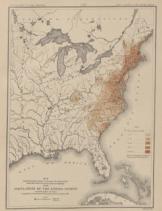
Population Distribution in 1790
View Larger
The Census Office produced its first significant map in 1854: an illustration by Superintendent of the Census J.D.B. DeBow that accompanied an 1850 census report. In the latter part of the nineteenth century, the Census Office published, under the direction of Superintendent Francis Walker and geographer Henry Gannet, a series of highly acclaimed statistical atlases.
Although interest in the statistical atlases declined and were ultimately canceled for the 1930 census, the Census Bureau continued to produce a large array of maps, both to disseminate statistics and to aid in the enumeration process. This section presents some of the more notable maps produced by the Census Bureau and its predecessors.

