

Images & Animations
-
Credit
NASA/Goddard Space Flight Center Scientific Visualization Studio
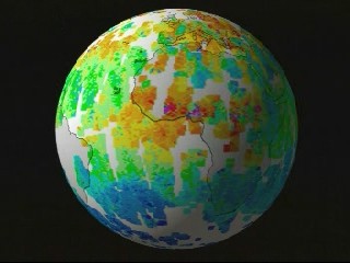
MOPITT Globe Unwrap with Zoom into TRMM Fire Data
Global carbon monoxide as measured by MOPITT from March 5, 2000 to March 7, 2000 is shown on a globe, which then unwraps to a cartesian projection and zooms into the African Sahel, fading to data of fires from biomass burning from the VIRS instrument on TRMM. High values of carbon monoxide are shown in red and yellow, and the large areas of missing data in white are regions not seen by MOPITT during this three-day period.
Metadata
-
Sensor
TRMM/VIRS, Terra/MOPITT -
Animation ID
1135 -
Video ID
SVS2000-1001 -
Start Timecode
1:25:23:00 -
End Timecode
1:26:22:00 -
Animator
Tom Biddlecome -
Studio
SVS -
Visualization Date
2000/04/19 -
Scientist
Yoram Kaufman (NASA/GSFC) -
Datasets
Fires, Carbon Monoxide -
Keywords
Fire -
DLESE Subject
Natural hazards, Atmospheric science -
Data Date
2000/03/05-2000/03/07 -
Pao ID
g00-028_earth -
Animation Type
Regular