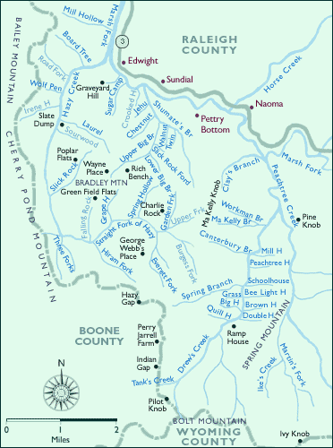
Features Along Route 3: From Hazy Creek to Peachtree Creek
- Bailey Mountain
- Bee Light Hollow
- Big Hollow
- Board Tree
- Brown Hollow
- Canterbury Branch
- Charlie Rock
- Cherry Pond Mountain
- Chestnut Hollow
- Clay's Branch
- Double Hollow
- Drew's Creek
- Edwight
- Everett Fork
- George Webb's Place
- Grape Hollow
- Graveyard Hill
- Grass
- Green Field Flats
- Hazy Creek
- Hazy Gap
- Hiram Fork
- Horse Creek
- Ike's Creek
- Indian Gap
- Ivy Knob
- Jehu
- Laurel Hollow
- Lower Big Branch
- Ma Kelly Branch
- Ma Kelly Knob
- Marsh Fork
- Martin's Fork
- Mill Hollow
- Naoma
- Peachtree Creek
- Peachtree Hollow
- Perry Jarrell Farm
- Pettry Bottom
- Pilot Knob
- Pine Knob
- Poplar Flats
- Quill Hollow
- Ramp House
- Rich Bench
- Schoolhouse Hollow
- Shumate's Branch
- Slate Dump
- Slick Rock
- Slick Rock Ford
- Spring Branch
- Straight Fork of Hazy
- Sugar Camp
- Sundial
- Tank's Creek
- Three Forks
- Twin
- Upper Big Branch
- Walnut Hollow
- Wayne Place
- Wolf Pen
- Workman Branch
The maps for this site are based on U.S.G.S. topographic quads and were notated in field interviews conducted between 1994 and 1999. Dave Bailey, Woody Boggs, Ben Burnside, Ed Cantley, Tony Dickens, Paul Fitzwater, Ivan Jarrell, Ricky Meadows, Howard Miller, Elbert Pettry, Wesley Scarbrough, and Rocky Turner helped fill out the quads with local names, and their accounts of places and origins of names may be heard by clicking on a number of the creeks with side hollows. Ben Burnside, Woody Boggs, and Ricky Meadows provided supplementary sketches as well. Tom Suzuki transformed the sketches and the annotated quads into these maps, which were modified (10/2000) for navigational purposes.