
 Feeds & Data
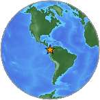
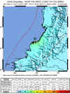
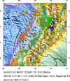
Magnitude 6.8 - NEAR THE WEST COAST OF COLOMBIA
2007 September 10 01:49:11 UTC
Earthquake Details
| Magnitude | 6.8 |
|---|---|
| Date-Time |
|
| Location | 2.945°N, 78.069°W |
| Depth | 10 km (6.2 miles) set by location program |
| Region | NEAR THE WEST COAST OF COLOMBIA |
| Distances | 150 km (95 miles) SW of Buenaventura, Colombia 155 km (95 miles) NE of Tumaco, Colombia 165 km (105 miles) WNW of Popayan, Colombia 475 km (295 miles) WSW of BOGOTA, Colombia |
| Location Uncertainty | horizontal +/- 6.5 km (4.0 miles); depth fixed by location program |
| Parameters | NST=170, Nph=170, Dmin=302 km, Rmss=1.22 sec, Gp=126°, M-type=centroid moment magnitude (Mw), Version=7 |
| Source |
|
| Event ID | us2007hcah |
- This event has been reviewed by a seismologist.
- Did you feel it? Report shaking and damage at your location. You can also view a map displaying accumulated data from your report and others.
Earthquake Summary

The following is a release by the United States Geological Survey, National Earthquake Information Center: An earthquake occurred NEAR THE WEST COAST OF COLOMBIA, about 150 km (95 miles) NNE of Tumaco or 480 km (295 miles) WSW of Bogota at 7:49 PM MDT, Sep 9, 2007 (8:49 PM local time in Colombia). The magnitude and location may be revised when additional data and further analysis results are available.
Felt Reports
WP 6.9 (GS).
Earthquake Maps


Scientific & Technical Information

- Preliminary Earthquake Report
- U.S. Geological Survey, National Earthquake Information Center:
World Data Center for Seismology, Denver
