Monthly Snow Climatology, 1979-2002 (WMS)
|
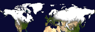
The extent of snow and ice that covers the earth's surface in the northern hemisphere grows and shrinks with the seasons. This animations shows the average snow and ice cover for a given month over a 24-year period, 1979 - 2002. It shows how often a particular point is covered with snow in a given month. The SVS Image Server gives each particular image in the animation the last date for which the data was used in creating that image, even though each of the images covers a span of years for a particular month.
|
|

|
|
This animation shows the average snow cover for a given month over a 23-year period. The frames provide a transparent overlay. A background image taken from NASA's Blue Marble is also provided.
Duration: 6.0 seconds
Available formats:
600x200 (29.97 fps)
MPEG-2
3 MB
600x200
Frames
320x107
PNG
104 KB
80x40
PNG
13 KB
160x80
PNG
47 KB
320x240 (29.97 fps)
MPEG-1
1 MB
640x480 (30 fps)
MPEG-1
1 MB
320x240 (29.97 fps)
X-FLV
461 KB
How to play our movies
|
|
This product is available through our Web Map Service.
Click here to learn more.
|
|
|
|
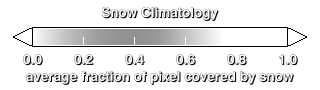
Color bar for the snow cover.
Available formats:
320 x 90
PNG
14 KB
|
|
|
Back to Top
|


