|
|
 |
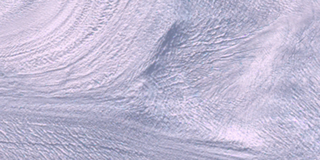
Jakobshavn Glacier Ice Flow (WMS)
|
Since measurements of Jakobshavn Isbrae were first taken in 1850, the glacier has gradually receded, finally coming to rest at a certain point for the past 5 decades. However, from 1997 to 2003, the glacier has begun to recede again, this time almost doubling in speed. The finding is important for many reasons. For starters, as more ice moves from glaciers on land into the ocean, it raises sea levels. Jakobshavn Isbrae is Greenland's largest outlet glacier, draining 6.5 percent of Greenland's ice sheet area. The ice stream's speed-up and near-doubling of ice flow from land into the ocean has increased the rate of sea level rise by about .06 millimeters (about .002 inches) per year, or roughly 4 percent of the 20th century rate of sea level increase. This animation shows a time-lapse sequence of the ice flowing toward the ocean. In recent years, even ice that has traditionally remained in place is now being pulled down to the edge of land.
|
|

|
|
This animation shows a time-lapse sequence of the glaciers ice flow. This animation shows only a small section of the full imagery. The full imagery can be found in the frames area.
Duration: 3.0 seconds
Available formats:
700x1700
Frames
640x480 (29.97 fps)
MPEG-1
1 MB
160x80
PNG
26 KB
320x160
PNG
105 KB
80x40
PNG
6 KB
How to play our movies
|
|
This product is available through our Web Map Service.
Click here to learn more.
|
| Animation Number: | 3141 |
| Completed: | 2005-03-30 |
| Animators: | Eric Sokolowsky (GST) (Lead) |
| | Alex Kekesi (GST) |
| Scientist: | Waleed Abdalati (NASA/HQ) |
| Platform/Sensor/Data Set: | Landsat-7/ETM+ (2001-03-17, 2001-05-04, 2001-05-20, 2001-07-07, 2002-03-04, 2002-03-29, 2002-04-28, 2002-05-23, 2002-06-17, 2002-07-01, 2002-09-03, 2003-03-23, 2003-05-19) |
| Series: | WMS |
Keywords:
DLESE
>> Cryology
GCMD
>> EARTH SCIENCE
>> Cryosphere
>> Glaciers/Ice Sheets
>> Glacier Motion/Ice Sheet Motion
GCMD
>> EARTH SCIENCE
>> Hydrosphere
>> Glaciers/Ice Sheets
>> Glacier Motion/Ice Sheet Motion
GCMD
>> EARTH SCIENCE
>> Spectral/Engineering
>> Visible Wavelengths
>> Visible Imagery
GCMD
>> Location
>> Greenland
|
 Google Earth KML file is available here.
 |
| DEPC Metadata is available here. |
|
Please give credit for this item to
NASA/Goddard Space Flight Center
Scientific Visualization Studio |
|
Back to Top
|
|
|
|

