

Images & Animations
-
Credit
NASA/Goddard Space Flight Center Scientific Visualization Studio
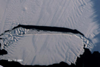
Pine Island Iceberg Formation
This animation is a sequence showing the formation of the Pine Island iceberg and the glacial seaward flow upstream from the crack. It is a series of MISR images from the Terra satellite on top of the continental Radarsat view of Antarctica. The Pine Island Glacier is the largest discharger of ice in Antarctica and the continent's fastest moving glacier. Even so, when a large crack formed across the glacier in mid 2000, it was surprising how fast the crack expanded, 15 meters per day, and how soon the resulting iceberg broke off, mid-November, 2001. This iceberg, called B-21, is 42 kilometers by 17 kilometers and contains seven years of glacier outflow released to the sea in a single event.
November 12, 2001
Metadata
-
Sensor
Terra/MISR -
Animation ID
2344 -
Video ID
SVS2002-0008 -
Start Timecode
01:00:09:00 -
End Timecode
01:01:21:28 -
Animator
Lori Perkins -
Studio
SVS -
Visualization Date
2002/01/15 -
Scientist
Bob Bindschadler (NASA/GSFC), Dave Diner (NASA/JPL) -
Keywords
Iceberg, Sea Ice -
DLESE Subject
Cryology -
Data Date
RADARSAT: 1997/09/26-1997/11/04, Terra/MISR: 2001/09/08-2001/11/12 -
Animation Type
Regular